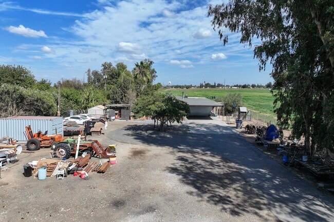
Property Record
1740 S Cornelia Ave, Fresno, CA 93706
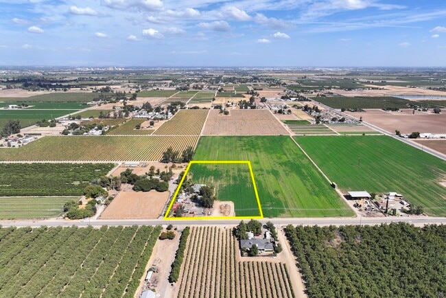

This Property Is For Sale
NEARBY LISTINGS FOR SALE OR LEASE
Property Detail
1740 S Cornelia Ave
Fresno, CA
Bank Of California Tract
327-110-57
5 AC IN SW1/4 SEC 14 BANK OF CALIF TR
Farms
Fresno
X
California
06019C2085H
6
2025
5 AC
2025
W Outlying Fresno County
008600
Fresno
1,984 SF
DEMOGRAPHICS near 1740 S Cornelia Ave
1 Mile
3 Mile
5 Mile
2024 Total Population
331
4,663
68,931
2029 Population
333
4,701
69,553
Pop Growth 2024-2029
+ 0.60%
+ 0.81%
+ 0.90%
Average Age
37
38
35
2024 Total Households
90
1,432
19,695
HH Growth 2024-2029
+ 1.11%
+ 0.63%
+ 0.90%
Median Household Inc
$64,500
$61,765
$52,584
Avg Household Size
3.40
3.10
3.30
2024 Avg HH Vehicles
3.00
2.00
2.00
Median Home Value
$341,666
$367,631
$305,022
Median Year Built
1971
1974
1976
Nearby Places
Map Layers
Map Styles
 Street
 Aerial
- Restaurants
- Banks
- Shops
- Fitness
- Groceries
PUBLIC TRANSPORTATION
COMMUTER RAIL
Fresno (San Joaquins - Amtrak)
DRIVE
WALK
Distance
Fresno (San Joaquins - Amtrak)
16 min
9.6 mi
AIRPORT
Fresno Yosemite International
DRIVE
WALK
Distance
Fresno Yosemite International
22 min
12.9 mi
Freight Ports
Port of Stockton
DRIVE
WALK
Distance
Port of Stockton
160 min
130.5 mi
Nearby Properties
Address
Land Use
TOTAL SIZE
Lot Size
Zoning
Address
Land Use
TOTAL SIZE
Lot Size
Zoning
106,740 SF
63.59 AC
AE20
Address
Land Use
TOTAL SIZE
Lot Size
Zoning
49,471 SF
6.78 AC
M1
Address
Land Use
TOTAL SIZE
Lot Size
Zoning
7,020 SF
2.92 AC
M1
Address
Land Use
TOTAL SIZE
Lot Size
Zoning
2,048 SF
259 AC
AE20
Address
Land Use
TOTAL SIZE
Lot Size
Zoning
30,482 SF
2.56 AC
R1C
Address
Land Use
TOTAL SIZE
Lot Size
Zoning
2,146 SF
74.67 AC
AE20
Address
Land Use
TOTAL SIZE
Lot Size
Zoning
15.03 AC
M2
Address
Land Use
TOTAL SIZE
Lot Size
Zoning
17,020 SF
5.05 AC
M1
Address
Land Use
TOTAL SIZE
Lot Size
Zoning
74.77 AC
AE40
Address
Land Use
TOTAL SIZE
Lot Size
Zoning
5,721 SF
39.52 AC
AE20
Address
Land Use
TOTAL SIZE
Lot Size
Zoning
274.95 AC
AE20
Address
Land Use
TOTAL SIZE
Lot Size
Zoning
16,720 SF
12.46 AC
M1
Address
Land Use
TOTAL SIZE
Lot Size
Zoning
20,594 SF
4.70 AC
M2
Address
Land Use
TOTAL SIZE
Lot Size
Zoning
7,320 SF
7.43 AC
CH
Address
Land Use
TOTAL SIZE
Lot Size
Zoning
67.47 AC
R1
Address
Land Use
TOTAL SIZE
Lot Size
Zoning
1,104 SF
38.20 AC
AE20
Address
Land Use
TOTAL SIZE
Lot Size
Zoning
200 AC
AE20
Address
Land Use
TOTAL SIZE
Lot Size
Zoning
26.89 AC
M3
Address
Land Use
TOTAL SIZE
Lot Size
Zoning
73,340 SF
1.78 AC
M1
Address
Land Use
TOTAL SIZE
Lot Size
Zoning
77,700 SF
14.78 AC
M1
Address
Land Use
TOTAL SIZE
Lot Size
Zoning
76.58 AC
AE20
Address
Land Use
TOTAL SIZE
Lot Size
Zoning
10,292 SF
11.91 AC
AE20
Address
Land Use
TOTAL SIZE
Lot Size
Zoning
2,713 SF
158.77 AC
AE20
Address
Land Use
TOTAL SIZE
Lot Size
Zoning
18.63 AC
AE20
Address
Land Use
TOTAL SIZE
Lot Size
Zoning
1,927 SF
38.86 AC
AE20
Address
Land Use
TOTAL SIZE
Lot Size
Zoning
1,900 SF
79.97 AC
AE20
Address
Land Use
TOTAL SIZE
Lot Size
Zoning
1,873 SF
38.20 AC
AE20
Address
Land Use
TOTAL SIZE
Lot Size
Zoning
1,876 SF
40 AC
AE20
The World's #1 Commercial Real Estate Marketplace
Connect with us
© 2025 CoStar Group
The information above has been obtained from sources believed reliable. While we do not doubt its accuracy we have not verified it and make no guarantee, warranty or representation about it. It is your responsibility to independently confirm its accuracy and completeness. Any projections, opinions, assumptions, or estimates used are for example only and do not represent the current or future performance of the property. The value of this transaction to you depends on tax and other factors which should be evaluated by your tax, financial, and legal advisors. You and your advisors should conduct a careful, independent investigation of the property to determine to your satisfaction the suitability of the property for your needs.