Property Record
17401 Midlothian Tpke, Midlothian, VA 23113


NEARBY LISTINGS FOR SALE OR LEASE
-
-
View all Midlothian listings for sale on LoopNet.com
Property Detail
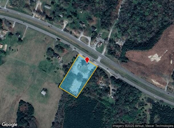
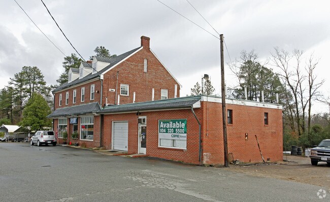
17401 Midlothian Tpke
706-70-78-09-900-000
S/L Route 60
Storebuilding
S/L RT 60
X
Chesterfield
51145C0165C
Virginia
2025
2.23 AC
2025
Swift Creek
100938
Richmond VA
5,707 SF
Richmond, VA
DEMOGRAPHICS near 17401 Midlothian Tpke
1 Mile
3 Mile
5 Mile
2024 Total Population
405
10,685
50,350
2029 Population
456
11,959
55,890
Pop Growth 2024-2029
+ 12.59%
+ 11.92%
+ 11.00%
Average Age
38
39
40
2024 Total Households
131
3,658
18,299
HH Growth 2024-2029
+ 12.98%
+ 11.89%
+ 11.06%
Median Household Inc
$176,428
$159,039
$126,278
Avg Household Size
3.10
2.90
2.70
2024 Avg HH Vehicles
2.00
2.00
2.00
Median Home Value
$589,286
$517,480
$447,233
Median Year Built
2010
2010
2004
Nearby Places
Map Layers
Map Styles
 Street
 Aerial
- Restaurants
- Banks
- Shops
- Fitness
- Groceries
PUBLIC TRANSPORTATION
AIRPORT
Richmond International
DRIVE
WALK
Distance
Richmond International
46 min
29.4 mi
Freight Ports
Virginia Port Authority - Richmond
DRIVE
WALK
Distance
Virginia Port Authority - Richmond
37 min
19.5 mi
Nearby Properties
Address
Land Use
TOTAL SIZE
Lot Size
Zoning
Address
Land Use
TOTAL SIZE
Lot Size
Zoning
578,400 SF
6.77 AC
I2 - GEN I
Address
Land Use
TOTAL SIZE
Lot Size
Zoning
332,521 SF
77.65 AC
I2 - GEN I
Address
Land Use
TOTAL SIZE
Lot Size
Zoning
112,053 SF
44.11 AC
R9 - SINGL
Address
Land Use
TOTAL SIZE
Lot Size
Zoning
100 SF
4.46 AC
I2 - GEN I
Address
Land Use
TOTAL SIZE
Lot Size
Zoning
163,704 SF
10.16 AC
I2 - GEN I
Address
Land Use
TOTAL SIZE
Lot Size
Zoning
77,008 SF
8.55 AC
I2 - GEN I
Address
Land Use
TOTAL SIZE
Lot Size
Zoning
99,934 SF
81.69 AC
A - AGRICU
Address
Land Use
TOTAL SIZE
Lot Size
Zoning
62,636 SF
9.14 AC
RMF - RES,
Address
Land Use
TOTAL SIZE
Lot Size
Zoning
132,360 SF
14.76 AC
I2 - GEN I
Address
Land Use
TOTAL SIZE
Lot Size
Zoning
149,648 SF
29.73 AC
CC
Address
Land Use
TOTAL SIZE
Lot Size
Zoning
249.81 AC
RTH - RES,
Address
Land Use
TOTAL SIZE
Lot Size
Zoning
210.30 AC
C3 - COMMU
Address
Land Use
TOTAL SIZE
Lot Size
Zoning
54,804 SF
0.61 AC
I2 - GEN I
Address
Land Use
TOTAL SIZE
Lot Size
Zoning
49.63 AC
C3 - COMMU
Address
Land Use
TOTAL SIZE
Lot Size
Zoning
1,250 SF
30.30 AC
I2 - GEN I
Address
Land Use
TOTAL SIZE
Lot Size
Zoning
138.73 AC
RTH - RES,
Address
Land Use
TOTAL SIZE
Lot Size
Zoning
89,833 SF
0.42 AC
C5 - GEN B
Address
Land Use
TOTAL SIZE
Lot Size
Zoning
78,000 SF
5.88 AC
I2 - GEN I
Address
Land Use
TOTAL SIZE
Lot Size
Zoning
20,172 SF
3.91 AC
I2 - GEN I
Address
Land Use
TOTAL SIZE
Lot Size
Zoning
70.13 AC
C3 - COMMU
Address
Land Use
TOTAL SIZE
Lot Size
Zoning
6,515 SF
2.89 AC
O2 - CORP
Address
Land Use
TOTAL SIZE
Lot Size
Zoning
43,108 SF
0.54 AC
I2 - GEN I
Address
Land Use
TOTAL SIZE
Lot Size
Zoning
16,390 SF
11.04 AC
A - AGRICU
Address
Land Use
TOTAL SIZE
Lot Size
Zoning
102.40 AC
RTH - RES,
Address
Land Use
TOTAL SIZE
Lot Size
Zoning
19,946 SF
3.78 AC
I2 - GEN I
Address
Land Use
TOTAL SIZE
Lot Size
Zoning
29,875 SF
5.88 AC
R9 - SINGL
Address
Land Use
TOTAL SIZE
Lot Size
Zoning
1,800 SF
5.25 AC
CC
Address
Land Use
TOTAL SIZE
Lot Size
Zoning
58,475 SF
5.21 AC
I1 - LT IN
Address
Land Use
TOTAL SIZE
Lot Size
Zoning
85.06 AC
R12 - SING
The World's #1 Commercial Real Estate Marketplace
Connect with us
© 2025 CoStar Group
The information above has been obtained from sources believed reliable. While we do not doubt its accuracy we have not verified it and make no guarantee, warranty or representation about it. It is your responsibility to independently confirm its accuracy and completeness. Any projections, opinions, assumptions, or estimates used are for example only and do not represent the current or future performance of the property. The value of this transaction to you depends on tax and other factors which should be evaluated by your tax, financial, and legal advisors. You and your advisors should conduct a careful, independent investigation of the property to determine to your satisfaction the suitability of the property for your needs.