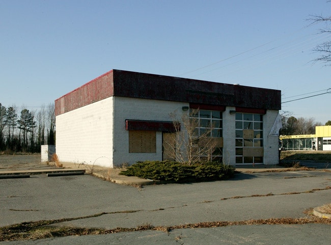
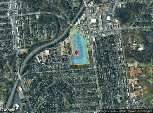
Property Record
1741 Dumbarton Rd, Richmond, VA 23227
NEARBY LISTINGS FOR SALE OR LEASE
Property Detail
1741 Dumbarton Rd
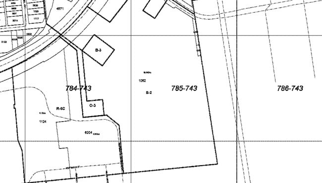
785-743-1062
00950A0000 0008; W S BROOK ROAD AC 28.67 106 A1 4
Commercialacreage
Henrico
X
Virginia
5101290027E
28.67 AC
2025
Laburnum/Rte 360
2025
Richmond VA
200806
Richmond, VA
DEMOGRAPHICS near 1741 Dumbarton Rd
1 Mile
3 Mile
5 Mile
2024 Total Population
10,426
77,746
235,675
2029 Population
10,646
79,310
240,725
Pop Growth 2024-2029
+ 2.11%
+ 2.01%
+ 2.14%
Average Age
45
41
39
2024 Total Households
4,781
35,891
104,162
HH Growth 2024-2029
+ 2.53%
+ 2.16%
+ 2.18%
Median Household Inc
$59,197
$60,179
$62,612
Avg Household Size
2.00
2.10
2.10
2024 Avg HH Vehicles
1.00
2.00
2.00
Median Home Value
$275,374
$270,677
$287,309
Median Year Built
1961
1962
1963
Nearby Places
Map Layers
Map Styles
 Street
 Aerial
- Restaurants
- Banks
- Shops
- Fitness
- Groceries
PUBLIC TRANSPORTATION
COMMUTER RAIL
Richmond Staples Mill Road Amtrak Station (Carolinian - Amtrak, Northeast Regional - Amtrak, Palmetto - Amtrak, Silver Meteor - Amtrak)
DRIVE
WALK
Distance
Richmond Staples Mill Road Amtrak Station (Carolinian - Amtrak, Northeast Regional - Amtrak, Palmetto - Amtrak, Silver Meteor - Amtrak)
8 min
4.2 mi
Richmond Main Street Amtrak Station (Northeast Regional - Amtrak)
DRIVE
WALK
Distance
Richmond Main Street Amtrak Station (Northeast Regional - Amtrak)
10 min
6.3 mi
AIRPORT
Richmond International
DRIVE
WALK
Distance
Richmond International
23 min
14.2 mi
Freight Ports
Virginia Port Authority - Richmond
DRIVE
WALK
Distance
Virginia Port Authority - Richmond
20 min
12.5 mi
Nearby Properties
Address
Land Use
TOTAL SIZE
Lot Size
Zoning
Address
Land Use
TOTAL SIZE
Lot Size
Zoning
494,791 SF
38.85 AC
R-6
Address
Land Use
TOTAL SIZE
Lot Size
Zoning
2,645,407 SF
116.30 AC
M2-C
Address
Land Use
TOTAL SIZE
Lot Size
Zoning
43,929 SF
46.83 AC
O-S
Address
Land Use
TOTAL SIZE
Lot Size
Zoning
482,958 SF
2.38 AC
M-1 LIGHT
Address
Land Use
TOTAL SIZE
Lot Size
Zoning
1,185 SF
2.54 AC
M-1 LIGHT
Address
Land Use
TOTAL SIZE
Lot Size
Zoning
382,570 SF
2.98 AC
UMUC
Address
Land Use
TOTAL SIZE
Lot Size
Zoning
14.89 AC
R-53 MULTI
Address
Land Use
TOTAL SIZE
Lot Size
Zoning
104,972 SF
108.49 AC
MIXE
Address
Land Use
TOTAL SIZE
Lot Size
Zoning
185,604 SF
2.30 AC
MULTIPLE Z
Address
Land Use
TOTAL SIZE
Lot Size
Zoning
16.14 AC
MULTIPLE Z
Address
Land Use
TOTAL SIZE
Lot Size
Zoning
321,552 SF
UMUC
Address
Land Use
TOTAL SIZE
Lot Size
Zoning
2.11 AC
M-1
Address
Land Use
TOTAL SIZE
Lot Size
Zoning
299,820 SF
3.16 AC
M-2 HEAVY
Address
Land Use
TOTAL SIZE
Lot Size
Zoning
80,519 SF
27.21 AC
I INSTITUT
Address
Land Use
TOTAL SIZE
Lot Size
Zoning
319,512 SF
20.33 AC
UMU
Address
Land Use
TOTAL SIZE
Lot Size
Zoning
250,000 SF
4.04 AC
Address
Land Use
TOTAL SIZE
Lot Size
Zoning
97,713 SF
21.60 AC
B-4 CENTRA
Address
Land Use
TOTAL SIZE
Lot Size
Zoning
2,909 SF
2.47 AC
M-1 LIGHT
Address
Land Use
TOTAL SIZE
Lot Size
Zoning
21,954 SF
4.79 AC
B-3 GENERA
Address
Land Use
TOTAL SIZE
Lot Size
Zoning
1,404 SF
30.52 AC
R-5
Address
Land Use
TOTAL SIZE
Lot Size
Zoning
3.25 AC
M-1 LIGHT
Address
Land Use
TOTAL SIZE
Lot Size
Zoning
126,303 SF
4.50 AC
M-1 LIGHT
Address
Land Use
TOTAL SIZE
Lot Size
Zoning
59,574 SF
313.03 AC
MIXE
Address
Land Use
TOTAL SIZE
Lot Size
Zoning
224,108 SF
2.10 AC
M-2 HEAVY
Address
Land Use
TOTAL SIZE
Lot Size
Zoning
227,000 SF
6.32 AC
R-6 SINGLE
Address
Land Use
TOTAL SIZE
Lot Size
Zoning
228,297 SF
15.79 AC
M-1 LIGHT
Address
Land Use
TOTAL SIZE
Lot Size
Zoning
232,020 SF
15.88 AC
B-4 CENTRA
Address
Land Use
TOTAL SIZE
Lot Size
Zoning
250,000 SF
Address
Land Use
TOTAL SIZE
Lot Size
Zoning
216,680 SF
4.45 AC
M-1 LIGHT
Address
Land Use
TOTAL SIZE
Lot Size
Zoning
110,790 SF
37.61 AC
R-2A
The World's #1 Commercial Real Estate Marketplace
Connect with us
© 2025 CoStar Group
The information above has been obtained from sources believed reliable. While we do not doubt its accuracy we have not verified it and make no guarantee, warranty or representation about it. It is your responsibility to independently confirm its accuracy and completeness. Any projections, opinions, assumptions, or estimates used are for example only and do not represent the current or future performance of the property. The value of this transaction to you depends on tax and other factors which should be evaluated by your tax, financial, and legal advisors. You and your advisors should conduct a careful, independent investigation of the property to determine to your satisfaction the suitability of the property for your needs.