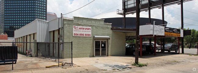
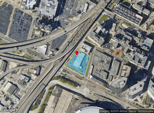
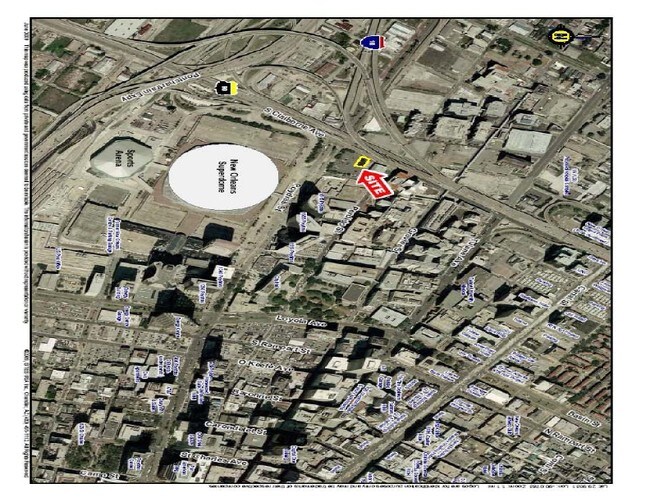
Property Record
1741 Poydras St, New Orleans, LA 70112
NEARBY LISTINGS FOR SALE OR LEASE
Property Detail
1741 Poydras St
New Orleans-Metairie, LA
SQ 430 POYDRAS ST, CLARA ST & N CLAIBORNE AVE LOT MB 297.1.5/192.8.1X272.1/290.2.7
1-04-1-036-13
Orleans
Vehiclerentalsvehiclesales
Louisiana
AE
mb
22051C0225F
1.62 AC
2025
New Orleans CBD
2025
New Orleans/Metairie/Kenner
013400
DEMOGRAPHICS near 1741 Poydras St
1 Mile
3 Mile
5 Mile
2024 Total Population
22,080
183,659
362,373
2029 Population
22,039
178,223
349,813
Pop Growth 2024-2029
(0.19%)
(2.96%)
(3.47%)
Average Age
40
41
41
2024 Total Households
11,591
87,509
161,776
HH Growth 2024-2029
+ 0.63%
(2.91%)
(3.49%)
Median Household Inc
$30,437
$51,329
$50,641
Avg Household Size
1.80
1.90
2.10
2024 Avg HH Vehicles
1.00
1.00
1.00
Median Home Value
$370,475
$379,121
$306,437
Median Year Built
1957
1947
1954
Nearby Places
Map Layers
Map Styles
 Street
 Aerial
- Restaurants
- Banks
- Shops
- Fitness
- Groceries
PUBLIC TRANSPORTATION
TRANSIT/SUBWAY
Canal and Claiborne (Canal-Cemeteries Streetcar - New Orleans Regional Transit Authority Streetcars (New Orleans Streetcars), Canal-Museum Streetcar - New Orleans Regional Transit Authority Streetcars (New Orleans Streetcars))
DRIVE
WALK
Distance
Canal and Claiborne (Canal-Cemeteries Streetcar - New Orleans Regional Transit Authority Streetcars (New Orleans Streetcars), Canal-Museum Streetcar - New Orleans Regional Transit Authority Streetcars (New Orleans Streetcars))
2 min
12 min
0.6 mi
Canal and Prieur (Canal-Cemeteries Streetcar - New Orleans Regional Transit Authority Streetcars (New Orleans Streetcars), Canal-Museum Streetcar - New Orleans Regional Transit Authority Streetcars (New Orleans Streetcars))
DRIVE
WALK
Distance
Canal and Prieur (Canal-Cemeteries Streetcar - New Orleans Regional Transit Authority Streetcars (New Orleans Streetcars), Canal-Museum Streetcar - New Orleans Regional Transit Authority Streetcars (New Orleans Streetcars))
2 min
13 min
0.7 mi
Canal and Marais/Lasalle (Canal-Cemeteries Streetcar - New Orleans Regional Transit Authority Streetcars (New Orleans Streetcars), Canal-Museum Streetcar - New Orleans Regional Transit Authority Streetcars (New Orleans Streetcars))
DRIVE
WALK
Distance
Canal and Marais/Lasalle (Canal-Cemeteries Streetcar - New Orleans Regional Transit Authority Streetcars (New Orleans Streetcars), Canal-Museum Streetcar - New Orleans Regional Transit Authority Streetcars (New Orleans Streetcars))
2 min
13 min
0.7 mi
Canal and Basin/Elk (Canal-Cemeteries Streetcar - New Orleans Regional Transit Authority Streetcars (New Orleans Streetcars), Canal-Museum Streetcar - New Orleans Regional Transit Authority Streetcars (New Orleans Streetcars))
DRIVE
WALK
Distance
Canal and Basin/Elk (Canal-Cemeteries Streetcar - New Orleans Regional Transit Authority Streetcars (New Orleans Streetcars), Canal-Museum Streetcar - New Orleans Regional Transit Authority Streetcars (New Orleans Streetcars))
2 min
15 min
0.8 mi
Canal and Rampart (Canal-Cemeteries Streetcar - New Orleans Regional Transit Authority Streetcars (New Orleans Streetcars), Canal-Museum Streetcar - New Orleans Regional Transit Authority Streetcars (New Orleans Streetcars))
DRIVE
WALK
Distance
Canal and Rampart (Canal-Cemeteries Streetcar - New Orleans Regional Transit Authority Streetcars (New Orleans Streetcars), Canal-Museum Streetcar - New Orleans Regional Transit Authority Streetcars (New Orleans Streetcars))
3 min
16 min
0.8 mi
COMMUTER RAIL
DRIVE
WALK
Distance
3 min
17 min
0.9 mi
AIRPORT
Louis Armstrong New Orleans International
DRIVE
WALK
Distance
Louis Armstrong New Orleans International
21 min
14.2 mi
Freight Ports
Port of New Orleans
DRIVE
WALK
Distance
Port of New Orleans
11 min
3.3 mi
Nearby Properties
Address
Land Use
TOTAL SIZE
Lot Size
Zoning
Address
Land Use
TOTAL SIZE
Lot Size
Zoning
300 SF
2.19 AC
LS
Address
Land Use
TOTAL SIZE
Lot Size
Zoning
85,052 SF
2.19 AC
LS
Address
Land Use
TOTAL SIZE
Lot Size
Zoning
80.92 AC
EC
Address
Land Use
TOTAL SIZE
Lot Size
Zoning
44.43 AC
CBD-4
Address
Land Use
TOTAL SIZE
Lot Size
Zoning
66.23 AC
CBD-4
Address
Land Use
TOTAL SIZE
Lot Size
Zoning
3.66 AC
MC
Address
Land Use
TOTAL SIZE
Lot Size
Zoning
834,043 SF
1.40 AC
CBD-2
Address
Land Use
TOTAL SIZE
Lot Size
Zoning
18.31 AC
CBD-4
Address
Land Use
TOTAL SIZE
Lot Size
Zoning
1.87 AC
CBD-2
Address
Land Use
TOTAL SIZE
Lot Size
Zoning
6.64 AC
Address
Land Use
TOTAL SIZE
Lot Size
Zoning
844,362 SF
5.85 AC
CBD-4
Address
Land Use
TOTAL SIZE
Lot Size
Zoning
0.12 AC
Address
Land Use
TOTAL SIZE
Lot Size
Zoning
30.63 AC
Address
Land Use
TOTAL SIZE
Lot Size
Zoning
444,121 SF
1.46 AC
CBD-1
Address
Land Use
TOTAL SIZE
Lot Size
Zoning
0.88 AC
CBD-2
Address
Land Use
TOTAL SIZE
Lot Size
Zoning
22.17 AC
Address
Land Use
TOTAL SIZE
Lot Size
Zoning
725,677 SF
54.19 AC
EC
Address
Land Use
TOTAL SIZE
Lot Size
Zoning
1.91 AC
CBD-1
Address
Land Use
TOTAL SIZE
Lot Size
Zoning
576,962 SF
3.31 AC
CBD-4
Address
Land Use
TOTAL SIZE
Lot Size
Zoning
1.79 AC
Address
Land Use
TOTAL SIZE
Lot Size
Zoning
609,449 SF
2 AC
EC
Address
Land Use
TOTAL SIZE
Lot Size
Zoning
512,729 SF
6.60 AC
Address
Land Use
TOTAL SIZE
Lot Size
Zoning
1.24 AC
CBD-1
Address
Land Use
TOTAL SIZE
Lot Size
Zoning
190,708 SF
1.09 AC
CBD-2
Address
Land Use
TOTAL SIZE
Lot Size
Zoning
499,287 SF
1.44 AC
VCE
Address
Land Use
TOTAL SIZE
Lot Size
Zoning
0.67 AC
CBD-3
Address
Land Use
TOTAL SIZE
Lot Size
Zoning
202,291 SF
4.04 AC
HU-RD2
Address
Land Use
TOTAL SIZE
Lot Size
Zoning
162,382 SF
1.25 AC
CBD-2
Address
Land Use
TOTAL SIZE
Lot Size
Zoning
258,024 SF
0.63 AC
CBD-2
Address
Land Use
TOTAL SIZE
Lot Size
Zoning
2.94 AC
CBD-1
The World's #1 Commercial Real Estate Marketplace
Connect with us
© 2025 CoStar Group
The information above has been obtained from sources believed reliable. While we do not doubt its accuracy we have not verified it and make no guarantee, warranty or representation about it. It is your responsibility to independently confirm its accuracy and completeness. Any projections, opinions, assumptions, or estimates used are for example only and do not represent the current or future performance of the property. The value of this transaction to you depends on tax and other factors which should be evaluated by your tax, financial, and legal advisors. You and your advisors should conduct a careful, independent investigation of the property to determine to your satisfaction the suitability of the property for your needs.