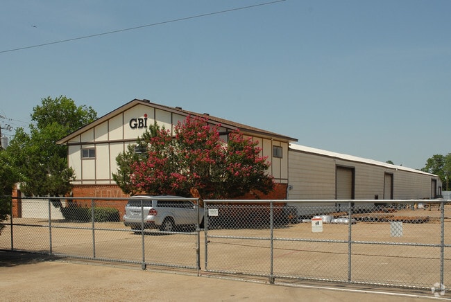
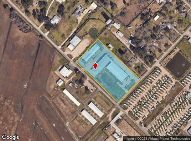
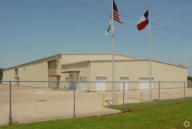
Property Record
17411 County Road 127, Pearland, TX 77581
NEARBY LISTINGS FOR SALE OR LEASE
Property Detail
17411 County Road 127
Houston-The Woodlands-Sugar Land, TX
West Friendswood (A0111 Perry & Austin)
8225-0038-120
WEST FRIENDSWOOD (A0111 PERRY & AUSTIN) LOT 1 (GBI) ACRES 5.0
Commercialnec
Brazoria
X
Texas
48039C0065K
1
2024
5 AC
2025
Southeast Outlier
660200
Houston
60,440 SF
DEMOGRAPHICS near 17411 County Road 127
1 Mile
3 Mile
5 Mile
2024 Total Population
3,052
42,891
153,736
2029 Population
3,354
45,912
161,855
Pop Growth 2024-2029
+ 9.90%
+ 7.04%
+ 5.28%
Average Age
38
40
38
2024 Total Households
1,031
15,228
51,699
HH Growth 2024-2029
+ 10.09%
+ 7.08%
+ 5.37%
Median Household Inc
$118,565
$111,461
$99,374
Avg Household Size
2.90
2.80
2.90
2024 Avg HH Vehicles
2.00
2.00
2.00
Median Home Value
$304,848
$312,220
$271,353
Median Year Built
1995
1992
1992
Nearby Places
Map Layers
Map Styles
 Street
 Aerial
- Restaurants
- Banks
- Shops
- Fitness
- Groceries
PUBLIC TRANSPORTATION
AIRPORT
William P Hobby
DRIVE
WALK
Distance
William P Hobby
22 min
10.6 mi
Freight Ports
Port of Houston
DRIVE
WALK
Distance
Port of Houston
33 min
18.8 mi
Nearby Properties
Address
Land Use
TOTAL SIZE
Lot Size
Zoning
Address
Land Use
TOTAL SIZE
Lot Size
Zoning
40.52 AC
0017
Address
Land Use
TOTAL SIZE
Lot Size
Zoning
83.37 AC
0004
Address
Land Use
TOTAL SIZE
Lot Size
Zoning
236,642 SF
11.48 AC
Address
Land Use
TOTAL SIZE
Lot Size
Zoning
7.42 AC
Address
Land Use
TOTAL SIZE
Lot Size
Zoning
128,754 SF
14.83 AC
Address
Land Use
TOTAL SIZE
Lot Size
Zoning
97,736 SF
16.49 AC
Address
Land Use
TOTAL SIZE
Lot Size
Zoning
142,155 SF
19.16 AC
SP
Address
Land Use
TOTAL SIZE
Lot Size
Zoning
144,879 SF
8.91 AC
Address
Land Use
TOTAL SIZE
Lot Size
Zoning
161,803 SF
54.82 AC
Address
Land Use
TOTAL SIZE
Lot Size
Zoning
110,990 SF
18.25 AC
Address
Land Use
TOTAL SIZE
Lot Size
Zoning
84,272 SF
16.93 AC
Address
Land Use
TOTAL SIZE
Lot Size
Zoning
113,376 SF
9.80 AC
Address
Land Use
TOTAL SIZE
Lot Size
Zoning
111,642 SF
9.53 AC
Address
Land Use
TOTAL SIZE
Lot Size
Zoning
115,805 SF
10.12 AC
SP
Address
Land Use
TOTAL SIZE
Lot Size
Zoning
99,042 SF
13 AC
MFRM
Address
Land Use
TOTAL SIZE
Lot Size
Zoning
229,097 SF
22.66 AC
Address
Land Use
TOTAL SIZE
Lot Size
Zoning
67,595 SF
4.97 AC
Address
Land Use
TOTAL SIZE
Lot Size
Zoning
138,839 SF
7.46 AC
MFRH
Address
Land Use
TOTAL SIZE
Lot Size
Zoning
83,995 SF
21.74 AC
CSC
Address
Land Use
TOTAL SIZE
Lot Size
Zoning
54,802 SF
12.63 AC
0014
Address
Land Use
TOTAL SIZE
Lot Size
Zoning
49.29 AC
0007
Address
Land Use
TOTAL SIZE
Lot Size
Zoning
80,715 SF
8.73 AC
Address
Land Use
TOTAL SIZE
Lot Size
Zoning
6,948 SF
54.94 AC
2080
Address
Land Use
TOTAL SIZE
Lot Size
Zoning
63,615 SF
6.42 AC
0010
Address
Land Use
TOTAL SIZE
Lot Size
Zoning
86,550 SF
8.45 AC
Address
Land Use
TOTAL SIZE
Lot Size
Zoning
151,863 SF
15.04 AC
Address
Land Use
TOTAL SIZE
Lot Size
Zoning
63,377 SF
2.71 AC
OBD
Address
Land Use
TOTAL SIZE
Lot Size
Zoning
76,646 SF
11.39 AC
SP
Address
Land Use
TOTAL SIZE
Lot Size
Zoning
28,019 SF
5.16 AC
Address
Land Use
TOTAL SIZE
Lot Size
Zoning
55,010 SF
5.50 AC
The World's #1 Commercial Real Estate Marketplace
Connect with us
© 2026 CoStar Group
The information above has been obtained from sources believed reliable. While we do not doubt its accuracy we have not verified it and make no guarantee, warranty or representation about it. It is your responsibility to independently confirm its accuracy and completeness. Any projections, opinions, assumptions, or estimates used are for example only and do not represent the current or future performance of the property. The value of this transaction to you depends on tax and other factors which should be evaluated by your tax, financial, and legal advisors. You and your advisors should conduct a careful, independent investigation of the property to determine to your satisfaction the suitability of the property for your needs.