Property Record
17413 Fm 2920 Rd, Tomball, TX 77377
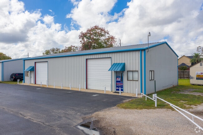

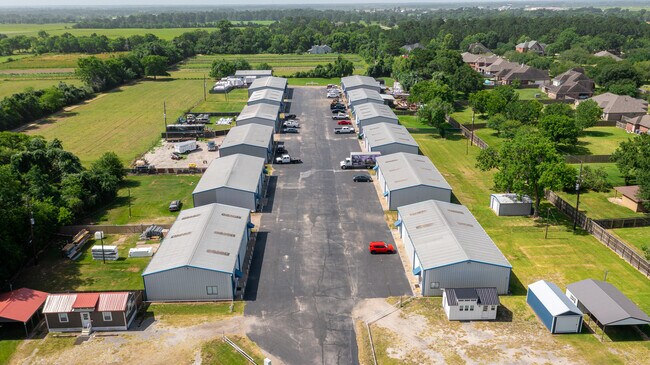
Property Detail
17413 Fm 2920 Rd
0402200000023
TR 7C ABST 204 C D GRENSHAW ABST 20 J H EDWARDS
Warehouse
HARRIS
B and X Area of moderate flood hazard, usually the area between the limits of the 100-year and 500-year floods.
Texas
2024
7.22 AC
2025
Northwest Hwy 6
555501
Houston
43,000 SF
Houston-Pasadena-The Woodlands, TX
NEARBY LISTINGS FOR SALE OR LEASE
DEMOGRAPHICS near 17413 Fm 2920 Rd
1 mile
3 mile
5 mile
2025 Total Population
993
13,636
59,400
2030 Population
1,089
15,408
66,426
Pop Growth 2025-2030
+ 9.67%
+ 13.00%
+ 11.83%
Average Age
40
40
39
2025 Total Households
351
4,669
20,298
HH Growth 2025-2030
+ 9.69%
+ 13.26%
+ 12.05%
Median Household Inc
$118,855
$126,469
$104,826
Avg Household Size
2.80
2.90
2.90
2025 Avg HH Vehicles
2.00
2.00
2.00
Median Home Value
$603,261
$479,347
$416,368
Median Year Built
1997
2008
2007
Nearby Places
Map Layers
Map Styles
 Street
 Aerial
Transit
 Traffic
 Biking
Places
Listings with unknown addresses are not visible on the map
- Restaurants
- Banks
- Shops
- Fitness
- Groceries
PUBLIC TRANSPORTATION
AIRPORT
George Bush Intcntl/Houston
Drive
Walk
Distance
George Bush Intcntl/Houston
40 min
30.9 mi
William P Hobby
Drive
Walk
Distance
William P Hobby
68 min
46.0 mi
SALE & LEASE HISTORY
LISTING DATE
SALE/LEASE

Sep 12, 2024
For Lease
Jun 27, 2022
For Sale
Jul 13, 2021
For Lease
Nearby Properties
Address
Land Use
TOTAL SIZE
Lot Size
Zoning
Address
Land Use
TOTAL SIZE
Lot Size
Zoning
326,902 SF
15.45 AC
Address
Land Use
TOTAL SIZE
Lot Size
Zoning
123,400 SF
15.08 AC
Address
Land Use
TOTAL SIZE
Lot Size
Zoning
56,700 SF
10 AC
Address
Land Use
TOTAL SIZE
Lot Size
Zoning
66,960 SF
17.39 AC
Address
Land Use
TOTAL SIZE
Lot Size
Zoning
27,542 SF
4.44 AC
Address
Land Use
TOTAL SIZE
Lot Size
Zoning
74,400 SF
6.43 AC
Address
Land Use
TOTAL SIZE
Lot Size
Zoning
62,322 SF
15.82 AC
Address
Land Use
TOTAL SIZE
Lot Size
Zoning
39,320 SF
6.46 AC
Address
Land Use
TOTAL SIZE
Lot Size
Zoning
83,930 SF
4.74 AC
Address
Land Use
TOTAL SIZE
Lot Size
Zoning
18,590 SF
15.24 AC
Address
Land Use
TOTAL SIZE
Lot Size
Zoning
76.78 AC
Address
Land Use
TOTAL SIZE
Lot Size
Zoning
73,040 SF
5.22 AC
Address
Land Use
TOTAL SIZE
Lot Size
Zoning
113,545 SF
8.24 AC
Address
Land Use
TOTAL SIZE
Lot Size
Zoning
1,184 SF
27.54 AC
Address
Land Use
TOTAL SIZE
Lot Size
Zoning
Address
Land Use
TOTAL SIZE
Lot Size
Zoning
25,063 SF
5 AC
Address
Land Use
TOTAL SIZE
Lot Size
Zoning
85,700 SF
6 AC
Address
Land Use
TOTAL SIZE
Lot Size
Zoning
6,729 SF
98.17 AC
Address
Land Use
TOTAL SIZE
Lot Size
Zoning
106,900 SF
14.27 AC
Address
Land Use
TOTAL SIZE
Lot Size
Zoning
Address
Land Use
TOTAL SIZE
Lot Size
Zoning
104.87 AC
Address
Land Use
TOTAL SIZE
Lot Size
Zoning
20,581 SF
14.85 AC
Address
Land Use
TOTAL SIZE
Lot Size
Zoning
12,938 SF
3.27 AC
Address
Land Use
TOTAL SIZE
Lot Size
Zoning
67,125 SF
10.41 AC
Address
Land Use
TOTAL SIZE
Lot Size
Zoning
3,428 SF
12.76 AC
Address
Land Use
TOTAL SIZE
Lot Size
Zoning
171.87 AC
Address
Land Use
TOTAL SIZE
Lot Size
Zoning
31.16 AC
Address
Land Use
TOTAL SIZE
Lot Size
Zoning
22.95 AC
Address
Land Use
TOTAL SIZE
Lot Size
Zoning
8,459 SF
2.50 AC
Address
Land Use
TOTAL SIZE
Lot Size
Zoning
23,930 SF
8.13 AC
The World's #1 Commercial Real Estate Marketplace
Connect with us
© 2026 CoStar Group
The information above has been obtained from sources believed reliable. While we do not doubt its accuracy we have not verified it and make no guarantee, warranty or representation about it. It is your responsibility to independently confirm its accuracy and completeness. Any projections, opinions, assumptions, or estimates used are for example only and do not represent the current or future performance of the property. The value of this transaction to you depends on tax and other factors which should be evaluated by your tax, financial, and legal advisors. You and your advisors should conduct a careful, independent investigation of the property to determine to your satisfaction the suitability of the property for your needs.