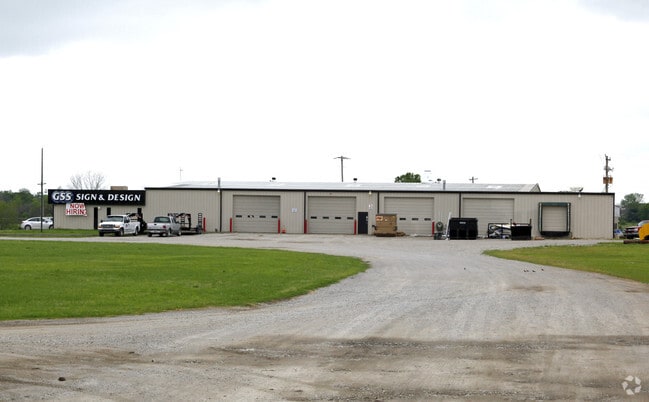
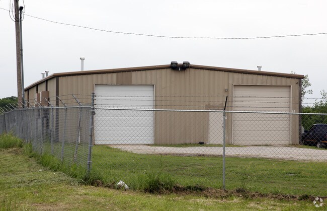
Property Record
17416 S Union Ave, Mounds, OK 74047


NEARBY LISTINGS FOR SALE OR LEASE
-
-
View all Mounds listings for sale on LoopNet.com
Property Detail
17416 S Union Ave
97234-72-34-12510
Unplatted
Warehouse
E/2 NE LYING E OF HWY 169 & 75 ROW LESS S639 THEREOF & LESS N1474.75 THEREOF & LESS E27 THEREOF SEC 34 17 12 8.91ACS
X
Tulsa
40143C0420K
Oklahoma
2025
8.91 AC
2025
South Tulsa
007703
Tulsa
26,450 SF
Tulsa, OK
DEMOGRAPHICS near 17416 S Union Ave
1 Mile
3 Mile
5 Mile
2024 Total Population
496
6,364
21,407
2029 Population
506
6,521
21,956
Pop Growth 2024-2029
+ 2.02%
+ 2.47%
+ 2.56%
Average Age
38
36
37
2024 Total Households
171
2,168
7,579
HH Growth 2024-2029
+ 2.34%
+ 2.49%
+ 2.60%
Median Household Inc
$111,170
$90,334
$73,218
Avg Household Size
2.90
2.90
2.80
2024 Avg HH Vehicles
3.00
2.00
2.00
Median Home Value
$313,415
$216,538
$197,224
Median Year Built
1995
1999
1995
Nearby Places
Map Layers
Map Styles
 Street
 Aerial
- Restaurants
- Banks
- Shops
- Fitness
- Groceries
PUBLIC TRANSPORTATION
AIRPORT
Tulsa International
DRIVE
WALK
Distance
Tulsa International
38 min
26.6 mi
Freight Ports
DRIVE
WALK
Distance
46 min
34.0 mi
Nearby Properties
Address
Land Use
TOTAL SIZE
Lot Size
Zoning
Address
Land Use
TOTAL SIZE
Lot Size
Zoning
49,735 SF
14.35 AC
CG
Address
Land Use
TOTAL SIZE
Lot Size
Zoning
116,016 SF
54.80 AC
CG
Address
Land Use
TOTAL SIZE
Lot Size
Zoning
6,702 SF
3.63 AC
AG
Address
Land Use
TOTAL SIZE
Lot Size
Zoning
18,560 SF
10.28 AC
AG
Address
Land Use
TOTAL SIZE
Lot Size
Zoning
38,476 SF
18.68 AC
CG
Address
Land Use
TOTAL SIZE
Lot Size
Zoning
68,298 SF
28.61 AC
CG
Address
Land Use
TOTAL SIZE
Lot Size
Zoning
18,078 SF
14.73 AC
IL
Address
Land Use
TOTAL SIZE
Lot Size
Zoning
22.20 AC
AG
Address
Land Use
TOTAL SIZE
Lot Size
Zoning
33,128 SF
1.83 AC
RM2
Address
Land Use
TOTAL SIZE
Lot Size
Zoning
107,943 SF
8.49 AC
PUD
Address
Land Use
TOTAL SIZE
Lot Size
Zoning
197,644 SF
32.39 AC
IL
Address
Land Use
TOTAL SIZE
Lot Size
Zoning
2,400 SF
19.62 AC
Address
Land Use
TOTAL SIZE
Lot Size
Zoning
6.76 AC
AG
Address
Land Use
TOTAL SIZE
Lot Size
Zoning
840 SF
10.43 AC
AG
Address
Land Use
TOTAL SIZE
Lot Size
Zoning
5,800 SF
1.86 AC
CS
Address
Land Use
TOTAL SIZE
Lot Size
Zoning
108,000 SF
8.81 AC
AG
Address
Land Use
TOTAL SIZE
Lot Size
Zoning
72,456 SF
3.77 AC
RM2
Address
Land Use
TOTAL SIZE
Lot Size
Zoning
30,160 SF
2.74 AC
CS
Address
Land Use
TOTAL SIZE
Lot Size
Zoning
83,598 SF
19.93 AC
IL
Address
Land Use
TOTAL SIZE
Lot Size
Zoning
58,200 SF
9.26 AC
CN
Address
Land Use
TOTAL SIZE
Lot Size
Zoning
27,000 SF
2.20 AC
CS
Address
Land Use
TOTAL SIZE
Lot Size
Zoning
23,605 SF
2.23 AC
CS
Address
Land Use
TOTAL SIZE
Lot Size
Zoning
24,224 SF
2.01 AC
CG
Address
Land Use
TOTAL SIZE
Lot Size
Zoning
36,000 SF
1.90 AC
AG
Address
Land Use
TOTAL SIZE
Lot Size
Zoning
2,234 SF
0.91 AC
CG
Address
Land Use
TOTAL SIZE
Lot Size
Zoning
5,944 SF
1.32 AC
CG
Address
Land Use
TOTAL SIZE
Lot Size
Zoning
4,748 SF
1.26 AC
CG
Address
Land Use
TOTAL SIZE
Lot Size
Zoning
18,920 SF
3 AC
CS
The World's #1 Commercial Real Estate Marketplace
Connect with us
© 2026 CoStar Group
The information above has been obtained from sources believed reliable. While we do not doubt its accuracy we have not verified it and make no guarantee, warranty or representation about it. It is your responsibility to independently confirm its accuracy and completeness. Any projections, opinions, assumptions, or estimates used are for example only and do not represent the current or future performance of the property. The value of this transaction to you depends on tax and other factors which should be evaluated by your tax, financial, and legal advisors. You and your advisors should conduct a careful, independent investigation of the property to determine to your satisfaction the suitability of the property for your needs.