Property Record
17420 Highway 190 E, Hammond, LA 70401
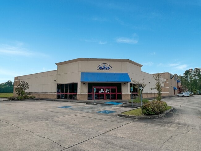

This Property Is For Sale
Current Lease Availabilities
Property Detail
17420 Highway 190 E
Hammond, LA
2.51A BEING LOT 1-R OF A RESUB OF LOT 1 OF ALACK BUSINESS PARK IN SEC 19 T6SR8E B610 P885 B674 P443 B947 P779 B1049 P52 B1052
02099306
Tangipahoa
Commercialnec
Louisiana
AE The base floodplain where base flood elevations are provided. AE Zones are now used on new format FIRMs instead of A1-A30 Zones.
1
2025
2.51 AC
2025
Louisiana South Area
954506
Other Market Areas
30,012 SF
NEARBY LISTINGS FOR SALE OR LEASE
DEMOGRAPHICS near 17420 Highway 190 E
1 mile
3 mile
5 mile
2025 Total Population
3,862
28,793
58,017
2030 Population
4,036
30,077
60,313
Pop Growth 2025-2030
+ 4.51%
+ 4.46%
+ 3.96%
Average Age
37
36
37
2025 Total Households
1,653
11,028
22,559
HH Growth 2025-2030
+ 4.66%
+ 4.78%
+ 4.18%
Median Household Inc
$60,360
$46,162
$52,444
Avg Household Size
2.30
2.30
2.40
2025 Avg HH Vehicles
2.00
2.00
2.00
Median Home Value
$259,574
$239,368
$230,617
Median Year Built
1997
1990
1995
Nearby Places
Map Layers
Map Styles
 Street
 Aerial
Layers
 Traffic
 Biking
Places
Listings with unknown addresses are not visible on the map
- Restaurants
- Banks
- Shops
- Fitness
- Groceries
PUBLIC TRANSPORTATION
COMMUTER RAIL
Hammond Amtrak Station (City of New Orleans - Amtrak)
Drive
Walk
Distance
Hammond Amtrak Station (City of New Orleans - Amtrak)
2 min
1.8 mi
Freight Ports
Port of Greater Baton Rouge
Drive
Walk
Distance
Port of Greater Baton Rouge
62 min
50.9 mi
Nearby Properties
Address
Land Use
TOTAL SIZE
Lot Size
Zoning
Address
Land Use
TOTAL SIZE
Lot Size
Zoning
309,554 SF
98.69 AC
Address
Land Use
TOTAL SIZE
Lot Size
Zoning
124,912 SF
12.50 AC
Address
Land Use
TOTAL SIZE
Lot Size
Zoning
666,424 SF
82.56 AC
Address
Land Use
TOTAL SIZE
Lot Size
Zoning
154,391 SF
12.30 AC
Address
Land Use
TOTAL SIZE
Lot Size
Zoning
170,004 SF
17.06 AC
Address
Land Use
TOTAL SIZE
Lot Size
Zoning
57,600 SF
2.07 AC
Address
Land Use
TOTAL SIZE
Lot Size
Zoning
82,860 SF
11.42 AC
Address
Land Use
TOTAL SIZE
Lot Size
Zoning
0.89 AC
Address
Land Use
TOTAL SIZE
Lot Size
Zoning
624,811 SF
41.75 AC
Address
Land Use
TOTAL SIZE
Lot Size
Zoning
24,931 SF
2.67 AC
Address
Land Use
TOTAL SIZE
Lot Size
Zoning
61,000 SF
11.91 AC
Address
Land Use
TOTAL SIZE
Lot Size
Zoning
1.56 AC
Address
Land Use
TOTAL SIZE
Lot Size
Zoning
52,074 SF
7.40 AC
Address
Land Use
TOTAL SIZE
Lot Size
Zoning
127,380 SF
9.70 AC
Address
Land Use
TOTAL SIZE
Lot Size
Zoning
147.07 AC
Address
Land Use
TOTAL SIZE
Lot Size
Zoning
201,555 SF
11.17 AC
Address
Land Use
TOTAL SIZE
Lot Size
Zoning
73,922 SF
9.99 AC
Address
Land Use
TOTAL SIZE
Lot Size
Zoning
108,000 SF
9.78 AC
Address
Land Use
TOTAL SIZE
Lot Size
Zoning
22,000 SF
5.56 AC
Address
Land Use
TOTAL SIZE
Lot Size
Zoning
47,960 SF
9.16 AC
Address
Land Use
TOTAL SIZE
Lot Size
Zoning
96,064 SF
5.03 AC
Address
Land Use
TOTAL SIZE
Lot Size
Zoning
85,430 SF
6.44 AC
Address
Land Use
TOTAL SIZE
Lot Size
Zoning
60,480 SF
7.28 AC
Address
Land Use
TOTAL SIZE
Lot Size
Zoning
165,402 SF
28.50 AC
Address
Land Use
TOTAL SIZE
Lot Size
Zoning
20,128 SF
20.77 AC
Address
Land Use
TOTAL SIZE
Lot Size
Zoning
22,507 SF
0.63 AC
Address
Land Use
TOTAL SIZE
Lot Size
Zoning
43,595 SF
10.17 AC
Address
Land Use
TOTAL SIZE
Lot Size
Zoning
35,100 SF
3.20 AC
Address
Land Use
TOTAL SIZE
Lot Size
Zoning
353.46 AC
Address
Land Use
TOTAL SIZE
Lot Size
Zoning
90,605 SF
9.76 AC
The World's #1 Commercial Real Estate Marketplace
Connect with us
© 2026 CoStar Group
The information above has been obtained from sources believed reliable. While we do not doubt its accuracy we have not verified it and make no guarantee, warranty or representation about it. It is your responsibility to independently confirm its accuracy and completeness. Any projections, opinions, assumptions, or estimates used are for example only and do not represent the current or future performance of the property. The value of this transaction to you depends on tax and other factors which should be evaluated by your tax, financial, and legal advisors. You and your advisors should conduct a careful, independent investigation of the property to determine to your satisfaction the suitability of the property for your needs.