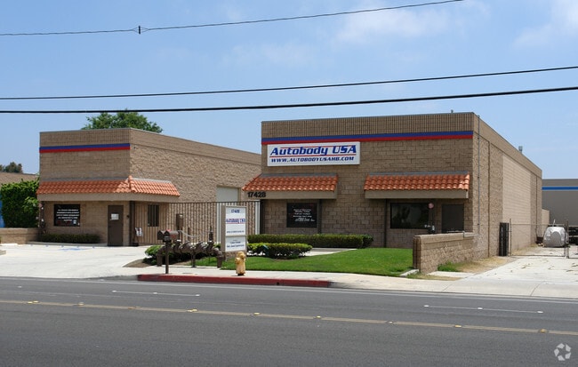
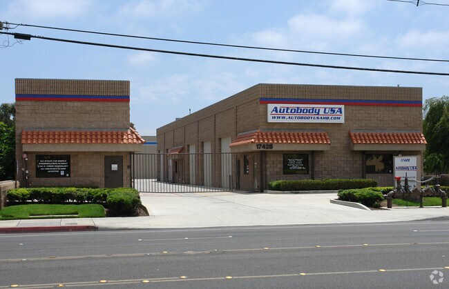
Property Record
17422 Gothard St, Huntington Beach, CA 92647

NEARBY LISTINGS FOR SALE OR LEASE
Property Detail
17422 Gothard St
Anaheim-Santa Ana-Irvine, CA
Parcel Map No 79-558
165-411-16
S TWP 5 RGE 11 SEC 26 SEC 26 T 5 R 11 NLY 80 FT SLY 340 FT SE1/4 SE1/4
Industrialgeneral
Orange
X
California
06059C0253J
0.40 AC
2024
Huntington Beach
2025
Orange County (California)
099402
DEMOGRAPHICS near 17422 Gothard St
1 Mile
3 Mile
5 Mile
2024 Total Population
25,076
192,536
434,238
2029 Population
24,922
190,079
429,144
Pop Growth 2024-2029
(0.61%)
(1.28%)
(1.17%)
Average Age
38
42
42
2024 Total Households
8,702
70,396
149,593
HH Growth 2024-2029
(0.69%)
(1.41%)
(1.23%)
Median Household Inc
$86,319
$103,398
$95,442
Avg Household Size
2.70
2.60
2.80
2024 Avg HH Vehicles
2.00
2.00
2.00
Median Home Value
$742,074
$857,902
$818,882
Median Year Built
1971
1972
1971
Nearby Places
Map Layers
Map Styles
 Street
 Aerial
- Restaurants
- Banks
- Shops
- Fitness
- Groceries
PUBLIC TRANSPORTATION
AIRPORT
John Wayne/Orange County
DRIVE
WALK
Distance
John Wayne/Orange County
14 min
9.0 mi
Long Beach (Daugherty Field)
DRIVE
WALK
Distance
Long Beach (Daugherty Field)
22 min
15.2 mi
Los Angeles International
DRIVE
WALK
Distance
Los Angeles International
45 min
34.0 mi
Nearby Properties
Address
Land Use
TOTAL SIZE
Lot Size
Zoning
Address
Land Use
TOTAL SIZE
Lot Size
Zoning
Address
Land Use
TOTAL SIZE
Lot Size
Zoning
Address
Land Use
TOTAL SIZE
Lot Size
Zoning
352,956 SF
16.70 AC
Address
Land Use
TOTAL SIZE
Lot Size
Zoning
Address
Land Use
TOTAL SIZE
Lot Size
Zoning
Address
Land Use
TOTAL SIZE
Lot Size
Zoning
263,121 SF
14.05 AC
Address
Land Use
TOTAL SIZE
Lot Size
Zoning
Address
Land Use
TOTAL SIZE
Lot Size
Zoning
Address
Land Use
TOTAL SIZE
Lot Size
Zoning
Address
Land Use
TOTAL SIZE
Lot Size
Zoning
292,787 SF
4.95 AC
Address
Land Use
TOTAL SIZE
Lot Size
Zoning
Address
Land Use
TOTAL SIZE
Lot Size
Zoning
207,271 SF
9.09 AC
Address
Land Use
TOTAL SIZE
Lot Size
Zoning
Address
Land Use
TOTAL SIZE
Lot Size
Zoning
Address
Land Use
TOTAL SIZE
Lot Size
Zoning
Address
Land Use
TOTAL SIZE
Lot Size
Zoning
35.40 AC
Address
Land Use
TOTAL SIZE
Lot Size
Zoning
Address
Land Use
TOTAL SIZE
Lot Size
Zoning
23.41 AC
Address
Land Use
TOTAL SIZE
Lot Size
Zoning
168,744 SF
7.61 AC
Address
Land Use
TOTAL SIZE
Lot Size
Zoning
214,935 SF
9.31 AC
Address
Land Use
TOTAL SIZE
Lot Size
Zoning
Address
Land Use
TOTAL SIZE
Lot Size
Zoning
151,679 SF
8.71 AC
Address
Land Use
TOTAL SIZE
Lot Size
Zoning
5.76 AC
Address
Land Use
TOTAL SIZE
Lot Size
Zoning
Address
Land Use
TOTAL SIZE
Lot Size
Zoning
5,159 SF
17.44 AC
Address
Land Use
TOTAL SIZE
Lot Size
Zoning
203,886 SF
12.32 AC
Address
Land Use
TOTAL SIZE
Lot Size
Zoning
178,964 SF
11.62 AC
Address
Land Use
TOTAL SIZE
Lot Size
Zoning
Address
Land Use
TOTAL SIZE
Lot Size
Zoning
Address
Land Use
TOTAL SIZE
Lot Size
Zoning
The World's #1 Commercial Real Estate Marketplace
Connect with us
© 2025 CoStar Group
The information above has been obtained from sources believed reliable. While we do not doubt its accuracy we have not verified it and make no guarantee, warranty or representation about it. It is your responsibility to independently confirm its accuracy and completeness. Any projections, opinions, assumptions, or estimates used are for example only and do not represent the current or future performance of the property. The value of this transaction to you depends on tax and other factors which should be evaluated by your tax, financial, and legal advisors. You and your advisors should conduct a careful, independent investigation of the property to determine to your satisfaction the suitability of the property for your needs.