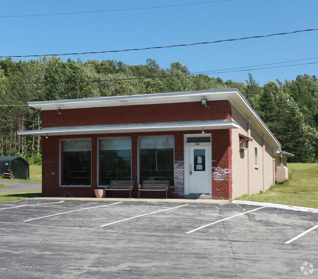
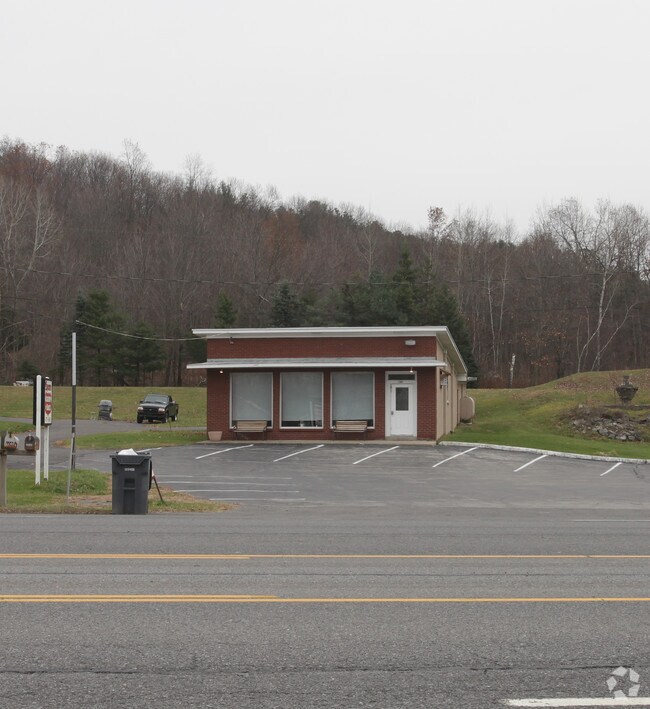
Property Record
1744 Route 9, Castleton On Hudson, NY 12033

Property Detail
1744 Route 9
Albany-Schenectady-Troy, NY
DWELLING 40000 STORE 27800
4489-200-6-7
RENSSELAER
Multifamilydwelling
New York
HC
7.000
2025
2.32 AC
2025
Outer Rensselaer County
052502
Albany/Schenectady/Troy
1,920 SF
NEARBY LISTINGS FOR SALE OR LEASE
-
-
View all Castleton On Hudson listings for sale on LoopNet.com
DEMOGRAPHICS near 1744 Route 9
1 mile
3 mile
5 mile
2025 Total Population
491
6,760
21,204
2030 Population
490
6,760
21,223
Pop Growth 2025-2030
(0.20%)
0.00%
+ 0.09%
Average Age
44
45
44
2025 Total Households
198
2,784
8,720
HH Growth 2025-2030
0.00%
(0.07%)
+ 0.01%
Median Household Inc
$105,921
$106,416
$99,005
Avg Household Size
2.50
2.40
2.40
2025 Avg HH Vehicles
2.00
2.00
2.00
Median Home Value
$270,833
$292,371
$286,957
Median Year Built
1971
1973
1971
Nearby Places
Map Layers
Map Styles
 Street
 Aerial
Layers
 Traffic
 Biking
Places
Listings with unknown addresses are not visible on the map
- Restaurants
- Banks
- Shops
- Fitness
- Groceries
PUBLIC TRANSPORTATION
AIRPORT
Albany International
Drive
Walk
Distance
Albany International
30 min
19.3 mi
Freight Ports
Albany, NY Port
Drive
Walk
Distance
Albany, NY Port
19 min
13.4 mi
Nearby Properties
Address
Land Use
TOTAL SIZE
Lot Size
Zoning
Address
Land Use
TOTAL SIZE
Lot Size
Zoning
1,015,740 SF
115.47 AC
HC
Address
Land Use
TOTAL SIZE
Lot Size
Zoning
278,670 SF
55.98 AC
PD-3
Address
Land Use
TOTAL SIZE
Lot Size
Zoning
108,473 SF
62.61 AC
R-40
Address
Land Use
TOTAL SIZE
Lot Size
Zoning
102,000 SF
11.80 AC
PD-3
Address
Land Use
TOTAL SIZE
Lot Size
Zoning
66,354 SF
10.26 AC
R-20
Address
Land Use
TOTAL SIZE
Lot Size
Zoning
20,320 SF
4.39 AC
PD-3
Address
Land Use
TOTAL SIZE
Lot Size
Zoning
23,200 SF
16.71 AC
HC
Address
Land Use
TOTAL SIZE
Lot Size
Zoning
7,384 SF
4.13 AC
HC
Address
Land Use
TOTAL SIZE
Lot Size
Zoning
Address
Land Use
TOTAL SIZE
Lot Size
Zoning
14,653 SF
1.95 AC
HC
Address
Land Use
TOTAL SIZE
Lot Size
Zoning
40,414 SF
3.33 AC
PD-1
Address
Land Use
TOTAL SIZE
Lot Size
Zoning
34,184 SF
17.63 AC
HC
Address
Land Use
TOTAL SIZE
Lot Size
Zoning
3,970 SF
2.52 AC
HC
Address
Land Use
TOTAL SIZE
Lot Size
Zoning
Address
Land Use
TOTAL SIZE
Lot Size
Zoning
1,920 SF
7 AC
RA
Address
Land Use
TOTAL SIZE
Lot Size
Zoning
29,580 SF
8.62 AC
PD-3
Address
Land Use
TOTAL SIZE
Lot Size
Zoning
78,000 SF
8.76 AC
HC
Address
Land Use
TOTAL SIZE
Lot Size
Zoning
28,800 SF
5.12 AC
PD-3
Address
Land Use
TOTAL SIZE
Lot Size
Zoning
3,975 SF
2.60 AC
HC
Address
Land Use
TOTAL SIZE
Lot Size
Zoning
648 SF
46.65 AC
RA
Address
Land Use
TOTAL SIZE
Lot Size
Zoning
18,678 SF
11.91 AC
HC
Address
Land Use
TOTAL SIZE
Lot Size
Zoning
6,000 SF
5.33 AC
Address
Land Use
TOTAL SIZE
Lot Size
Zoning
55,427 SF
4.88 AC
RA
Address
Land Use
TOTAL SIZE
Lot Size
Zoning
30,192 SF
9.06 AC
HC
Address
Land Use
TOTAL SIZE
Lot Size
Zoning
22.32 AC
HC
Address
Land Use
TOTAL SIZE
Lot Size
Zoning
6,440 SF
7.54 AC
PD-1
Address
Land Use
TOTAL SIZE
Lot Size
Zoning
27.46 AC
RA
Address
Land Use
TOTAL SIZE
Lot Size
Zoning
12,826 SF
206.90 AC
RA
Address
Land Use
TOTAL SIZE
Lot Size
Zoning
17,012 SF
4.85 AC
HC
Address
Land Use
TOTAL SIZE
Lot Size
Zoning
360 SF
6.78 AC
RM
The World's #1 Commercial Real Estate Marketplace
Connect with us
© 2026 CoStar Group
The information above has been obtained from sources believed reliable. While we do not doubt its accuracy we have not verified it and make no guarantee, warranty or representation about it. It is your responsibility to independently confirm its accuracy and completeness. Any projections, opinions, assumptions, or estimates used are for example only and do not represent the current or future performance of the property. The value of this transaction to you depends on tax and other factors which should be evaluated by your tax, financial, and legal advisors. You and your advisors should conduct a careful, independent investigation of the property to determine to your satisfaction the suitability of the property for your needs.