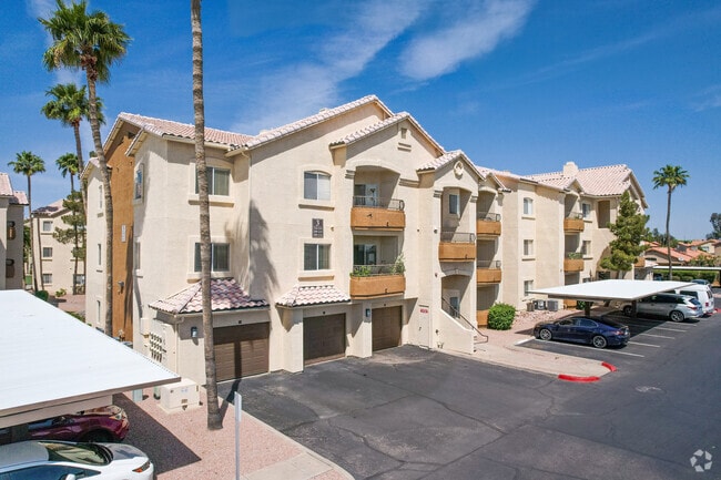
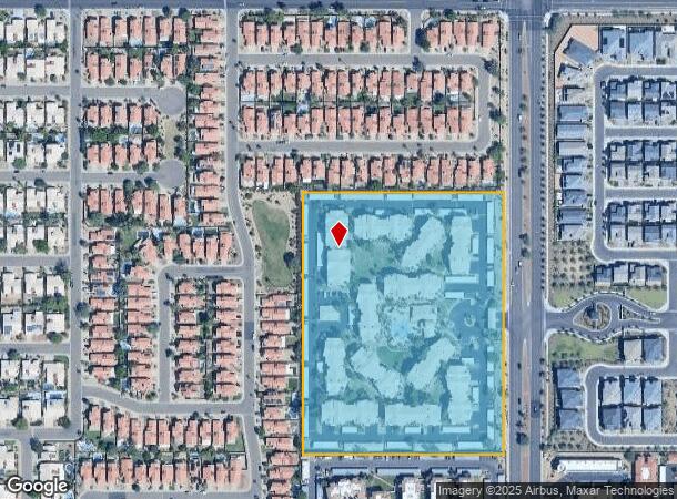
Property Record
17440 N Tatum Blvd, Phoenix, AZ 85032

NEARBY LISTINGS FOR SALE OR LEASE
-
-
View all Phoenix listings for sale on LoopNet.com
Property Detail
17440 N Tatum Blvd
215-18-008B
SE4 NE4 SE4 SEC 31 & ALSO S 110F OF PROP DAF NE4 NE4 SE4 SD SEC EX E 70F RD
Apartment
Maricopa
X
Arizona
04013C1315L
1
2025
10.44 AC
2025
Paradise Valley North
619800
Phoenix
305,811 SF
Phoenix-Mesa-Scottsdale, AZ
DEMOGRAPHICS near 17440 N Tatum Blvd
1 Mile
3 Mile
5 Mile
2024 Total Population
17,224
116,565
253,147
2029 Population
18,707
126,321
275,086
Pop Growth 2024-2029
+ 8.61%
+ 8.37%
+ 8.67%
Average Age
39
40
41
2024 Total Households
6,927
47,907
106,513
HH Growth 2024-2029
+ 8.60%
+ 8.64%
+ 8.95%
Median Household Inc
$104,672
$91,181
$89,431
Avg Household Size
2.40
2.40
2.30
2024 Avg HH Vehicles
2.00
2.00
2.00
Median Home Value
$518,664
$465,395
$474,391
Median Year Built
1991
1989
1990
Nearby Places
Map Layers
Map Styles
 Street
 Aerial
- Restaurants
- Banks
- Shops
- Fitness
- Groceries
PUBLIC TRANSPORTATION
AIRPORT
Phoenix Sky Harbor International
DRIVE
WALK
Distance
Phoenix Sky Harbor International
29 min
19.1 mi
Phoenix-Mesa Gateway
DRIVE
WALK
Distance
Phoenix-Mesa Gateway
58 min
41.5 mi
Freight Ports
Port of San Diego
DRIVE
WALK
Distance
Port of San Diego
416 min
371.6 mi
Nearby Properties
Address
Land Use
TOTAL SIZE
Lot Size
Zoning
Address
Land Use
TOTAL SIZE
Lot Size
Zoning
1,504,047 SF
40.43 AC
I-P
Address
Land Use
TOTAL SIZE
Lot Size
Zoning
35.76 AC
R1-18
Address
Land Use
TOTAL SIZE
Lot Size
Zoning
14.58 AC
Address
Land Use
TOTAL SIZE
Lot Size
Zoning
1,162,283 SF
115.23 AC
C-C
Address
Land Use
TOTAL SIZE
Lot Size
Zoning
670,926 SF
20.92 AC
I-P
Address
Land Use
TOTAL SIZE
Lot Size
Zoning
1,200,514 SF
47.28 AC
S1
Address
Land Use
TOTAL SIZE
Lot Size
Zoning
707,542 SF
28.49 AC
R-3A
Address
Land Use
TOTAL SIZE
Lot Size
Zoning
421,002 SF
23.48 AC
Address
Land Use
TOTAL SIZE
Lot Size
Zoning
487,786 SF
18.42 AC
S1
Address
Land Use
TOTAL SIZE
Lot Size
Zoning
342,574 SF
85.69 AC
R-18
Address
Land Use
TOTAL SIZE
Lot Size
Zoning
336,494 SF
55.06 AC
R-43AG
Address
Land Use
TOTAL SIZE
Lot Size
Zoning
539,135 SF
15.11 AC
R3A
Address
Land Use
TOTAL SIZE
Lot Size
Zoning
530,588 SF
20.58 AC
C-C
Address
Land Use
TOTAL SIZE
Lot Size
Zoning
495,877 SF
21.08 AC
C-C
Address
Land Use
TOTAL SIZE
Lot Size
Zoning
525,073 SF
8.51 AC
R4
Address
Land Use
TOTAL SIZE
Lot Size
Zoning
359,170 SF
37.47 AC
R-14
Address
Land Use
TOTAL SIZE
Lot Size
Zoning
375,257 SF
12 AC
M-H
Address
Land Use
TOTAL SIZE
Lot Size
Zoning
512,499 SF
23.03 AC
R3A
Address
Land Use
TOTAL SIZE
Lot Size
Zoning
24,200 SF
2.15 AC
R-18
Address
Land Use
TOTAL SIZE
Lot Size
Zoning
240,187 SF
14.26 AC
S1
Address
Land Use
TOTAL SIZE
Lot Size
Zoning
482,581 SF
20.45 AC
C-C
Address
Land Use
TOTAL SIZE
Lot Size
Zoning
297,352 SF
7.17 AC
R-18
Address
Land Use
TOTAL SIZE
Lot Size
Zoning
318,389 SF
37.57 AC
R-14
Address
Land Use
TOTAL SIZE
Lot Size
Zoning
388,480 SF
18.69 AC
PAD
Address
Land Use
TOTAL SIZE
Lot Size
Zoning
163,122 SF
8.63 AC
C-C
Address
Land Use
TOTAL SIZE
Lot Size
Zoning
327,729 SF
5.85 AC
R-18
Address
Land Use
TOTAL SIZE
Lot Size
Zoning
373,066 SF
13 AC
M-H
Address
Land Use
TOTAL SIZE
Lot Size
Zoning
163,122 SF
8.70 AC
C-C
Address
Land Use
TOTAL SIZE
Lot Size
Zoning
596,465 SF
66.04 AC
I-P
Address
Land Use
TOTAL SIZE
Lot Size
Zoning
167,532 SF
30 AC
R-14
The World's #1 Commercial Real Estate Marketplace
Connect with us
© 2026 CoStar Group
The information above has been obtained from sources believed reliable. While we do not doubt its accuracy we have not verified it and make no guarantee, warranty or representation about it. It is your responsibility to independently confirm its accuracy and completeness. Any projections, opinions, assumptions, or estimates used are for example only and do not represent the current or future performance of the property. The value of this transaction to you depends on tax and other factors which should be evaluated by your tax, financial, and legal advisors. You and your advisors should conduct a careful, independent investigation of the property to determine to your satisfaction the suitability of the property for your needs.