Property Record
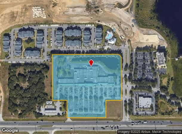
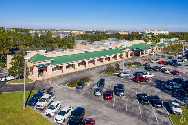
17445 Us Highway 192, Clermont, FL 34714

NEARBY LISTINGS FOR SALE OR LEASE
Property Detail
17445 Us Highway 192
36-24-26-0003-000-00700
FROM SOUTHEAST CORNER OF SECTION 36 TOWNSHIP 24 SOUTH RANGE 26 EAST RUN NORTH 00-11-19 WEST 2651.16 FEET TO EAST 1/4 CORNER SOUTH 89-19-32 WEST 1326.27 FEET SOUTH 00-09-31 EAST 660.97 FEET SOUTH 48-15-10 WEST 1176.63 FEET SOUTH 00-11-36 EAST 1000 FEE
Regionalshoppingcenterormallwithanchorstore
Lake
X
Florida
12105C0100G
7
0
11.78 AC
2026
Lake County
031317
Orlando
77,030 SF
Orlando-Kissimmee-Sanford, FL
DEMOGRAPHICS near 17445 Us Highway 192
1 Mile
3 Mile
5 Mile
2024 Total Population
7,898
53,153
94,338
2029 Population
9,661
64,693
114,346
Pop Growth 2024-2029
+ 22.32%
+ 21.71%
+ 21.21%
Average Age
45
38
37
2024 Total Households
3,779
20,281
34,193
HH Growth 2024-2029
+ 22.10%
+ 21.52%
+ 21.12%
Median Household Inc
$48,992
$60,276
$67,023
Avg Household Size
2.10
2.60
2.70
2024 Avg HH Vehicles
1.00
2.00
2.00
Median Home Value
$180,352
$253,803
$282,073
Median Year Built
2004
2004
2006
Nearby Places
Map Layers
Map Styles
 Street
 Aerial
- Restaurants
- Banks
- Shops
- Fitness
- Groceries
PUBLIC TRANSPORTATION
AIRPORT
Orlando International
DRIVE
WALK
Distance
Orlando International
41 min
27.5 mi
Freight Ports
Port of Tampa Bay
DRIVE
WALK
Distance
Port of Tampa Bay
80 min
65.3 mi
SALE & LEASE HISTORY
LISTING DATE
SALE/LEASE

Sep 25, 2016
For Lease
Nearby Properties
Address
Land Use
TOTAL SIZE
Lot Size
Zoning
Address
Land Use
TOTAL SIZE
Lot Size
Zoning
883,200 SF
75.26 AC
P-D
Address
Land Use
TOTAL SIZE
Lot Size
Zoning
414,620 SF
16.64 AC
P-D
Address
Land Use
TOTAL SIZE
Lot Size
Zoning
354,600 SF
12.03 AC
P-D
Address
Land Use
TOTAL SIZE
Lot Size
Zoning
480,142 SF
29.57 AC
OPD
Address
Land Use
TOTAL SIZE
Lot Size
Zoning
489,411 SF
19.04 AC
Address
Land Use
TOTAL SIZE
Lot Size
Zoning
364,023 SF
18.77 AC
OPD
Address
Land Use
TOTAL SIZE
Lot Size
Zoning
418,368 SF
12.66 AC
Address
Land Use
TOTAL SIZE
Lot Size
Zoning
128,000 SF
19.60 AC
P-D
Address
Land Use
TOTAL SIZE
Lot Size
Zoning
381,117 SF
10.72 AC
Address
Land Use
TOTAL SIZE
Lot Size
Zoning
321,417 SF
23.19 AC
Address
Land Use
TOTAL SIZE
Lot Size
Zoning
306,139 SF
19.77 AC
P-D
Address
Land Use
TOTAL SIZE
Lot Size
Zoning
333,280 SF
14.73 AC
Address
Land Use
TOTAL SIZE
Lot Size
Zoning
353,423 SF
16.51 AC
PUD
Address
Land Use
TOTAL SIZE
Lot Size
Zoning
316,273 SF
12.24 AC
Address
Land Use
TOTAL SIZE
Lot Size
Zoning
442,457 SF
28.76 AC
RC
Address
Land Use
TOTAL SIZE
Lot Size
Zoning
287,988 SF
P-D
Address
Land Use
TOTAL SIZE
Lot Size
Zoning
357,292 SF
1.34 AC
P-D
Address
Land Use
TOTAL SIZE
Lot Size
Zoning
277,616 SF
19.03 AC
Address
Land Use
TOTAL SIZE
Lot Size
Zoning
330,913 SF
16.74 AC
PUD
Address
Land Use
TOTAL SIZE
Lot Size
Zoning
273,164 SF
P-D
Address
Land Use
TOTAL SIZE
Lot Size
Zoning
375,326 SF
20.03 AC
PUD
Address
Land Use
TOTAL SIZE
Lot Size
Zoning
59,868 SF
0.81 AC
P-D
Address
Land Use
TOTAL SIZE
Lot Size
Zoning
272,106 SF
12.22 AC
Address
Land Use
TOTAL SIZE
Lot Size
Zoning
142,828 SF
429.01 AC
P-D
Address
Land Use
TOTAL SIZE
Lot Size
Zoning
315,346 SF
22.69 AC
PUD
Address
Land Use
TOTAL SIZE
Lot Size
Zoning
299,696 SF
9.79 AC
PUD
Address
Land Use
TOTAL SIZE
Lot Size
Zoning
283,492 SF
11.97 AC
PUD
Address
Land Use
TOTAL SIZE
Lot Size
Zoning
189.88 AC
P-D
Address
Land Use
TOTAL SIZE
Lot Size
Zoning
114,592 SF
18.46 AC
OCT
Address
Land Use
TOTAL SIZE
Lot Size
Zoning
196,553 SF
6.13 AC
The World's #1 Commercial Real Estate Marketplace
Connect with us
© 2026 CoStar Group
The information above has been obtained from sources believed reliable. While we do not doubt its accuracy we have not verified it and make no guarantee, warranty or representation about it. It is your responsibility to independently confirm its accuracy and completeness. Any projections, opinions, assumptions, or estimates used are for example only and do not represent the current or future performance of the property. The value of this transaction to you depends on tax and other factors which should be evaluated by your tax, financial, and legal advisors. You and your advisors should conduct a careful, independent investigation of the property to determine to your satisfaction the suitability of the property for your needs.