Property Record
1745 Loch Haven Dr, Roanoke, VA 24019


NEARBY LISTINGS FOR SALE OR LEASE
Property Detail
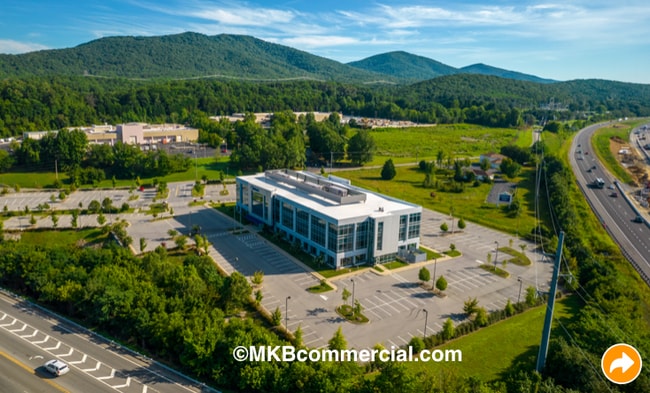
1745 Loch Haven Dr
036.10-01-14
Rt 419 Commercial 2
Officebuilding
TR A1 COMB FOR ET PURE ROANOKE LLC MASONS CREEK
X
Roanoke
51161C0133G
Virginia
2025
7.18 AC
2025
Northwest Roanoke
030100
Roanoke
72,042 SF
Roanoke, VA
DEMOGRAPHICS near 1745 Loch Haven Dr
1 mile
3 mile
5 mile
2024 Total Population
1,745
28,928
80,636
2029 Population
1,778
29,064
80,482
Pop Growth 2024-2029
+ 1.89%
+ 0.47%
(0.19%)
Average Age
41
40
41
2024 Total Households
706
11,375
33,346
HH Growth 2024-2029
+ 1.98%
+ 0.49%
(0.17%)
Median Household Inc
$81,250
$61,759
$56,703
Avg Household Size
2.40
2.30
2.30
2024 Avg HH Vehicles
2.00
2.00
2.00
Median Home Value
$182,006
$187,877
$186,374
Median Year Built
1979
1970
1968
Nearby Places
Map Layers
Map Styles
 Street
 Aerial
Transit
 Traffic
 Biking
Places
Listings with unknown addresses are not visible on the map
- Restaurants
- Banks
- Shops
- Fitness
- Groceries
PUBLIC TRANSPORTATION
COMMUTER RAIL
Roanoke (Northeast Regional - Amtrak)
Drive
Walk
Distance
Roanoke (Northeast Regional - Amtrak)
14 min
9.3 mi
AIRPORT
Roanoke/Blacksburg Regional (Woodrum Field)
Drive
Walk
Distance
Roanoke/Blacksburg Regional (Woodrum Field)
14 min
7.4 mi
Freight Ports
Virginia Port Authority - Richmond
Drive
Walk
Distance
Virginia Port Authority - Richmond
216 min
191.2 mi
Nearby Properties
Address
Land Use
TOTAL SIZE
Lot Size
Zoning
Address
Land Use
TOTAL SIZE
Lot Size
Zoning
81,148 SF
52.04 AC
CUDRSF
Address
Land Use
TOTAL SIZE
Lot Size
Zoning
69,831 SF
73.54 AC
HBD
Address
Land Use
TOTAL SIZE
Lot Size
Zoning
49,887 SF
2.28 AC
C1
Address
Land Use
TOTAL SIZE
Lot Size
Zoning
20,646 SF
23.33 AC
R2
Address
Land Use
TOTAL SIZE
Lot Size
Zoning
155,000 SF
3.78 AC
CUD
Address
Land Use
TOTAL SIZE
Lot Size
Zoning
83,167 SF
9.75 AC
C1
Address
Land Use
TOTAL SIZE
Lot Size
Zoning
181,455 SF
6.24 AC
RMF
Address
Land Use
TOTAL SIZE
Lot Size
Zoning
67,903 SF
11.96 AC
I2
Address
Land Use
TOTAL SIZE
Lot Size
Zoning
76,280 SF
9.51 AC
CUD
Address
Land Use
TOTAL SIZE
Lot Size
Zoning
123,651 SF
29.38 AC
R2S
Address
Land Use
TOTAL SIZE
Lot Size
Zoning
65,428 SF
34.05 AC
C1
Address
Land Use
TOTAL SIZE
Lot Size
Zoning
7,590 SF
14.18 AC
RMF
Address
Land Use
TOTAL SIZE
Lot Size
Zoning
100 SF
60.09 AC
RSF
Address
Land Use
TOTAL SIZE
Lot Size
Zoning
12,018 SF
8.78 AC
RMF
Address
Land Use
TOTAL SIZE
Lot Size
Zoning
106,884 SF
16.20 AC
R1S
Address
Land Use
TOTAL SIZE
Lot Size
Zoning
74,712 SF
2.13 AC
DBD
Address
Land Use
TOTAL SIZE
Lot Size
Zoning
100,915 SF
13.80 AC
HM
Address
Land Use
TOTAL SIZE
Lot Size
Zoning
23,600 SF
24.55 AC
LM
Address
Land Use
TOTAL SIZE
Lot Size
Zoning
9,021 SF
8.90 AC
RMF
Address
Land Use
TOTAL SIZE
Lot Size
Zoning
55,503 SF
9.69 AC
HBD
Address
Land Use
TOTAL SIZE
Lot Size
Zoning
5.76 AC
RMF
Address
Land Use
TOTAL SIZE
Lot Size
Zoning
103,770 SF
2.08 AC
HBD
Address
Land Use
TOTAL SIZE
Lot Size
Zoning
13,323 SF
4.31 AC
RM-2
Address
Land Use
TOTAL SIZE
Lot Size
Zoning
68,976 SF
1.77 AC
DBD
Address
Land Use
TOTAL SIZE
Lot Size
Zoning
63,192 SF
3.50 AC
HBD
Address
Land Use
TOTAL SIZE
Lot Size
Zoning
34,177 SF
5.01 AC
BCD
Address
Land Use
TOTAL SIZE
Lot Size
Zoning
67,222 SF
0.79 AC
DBD
Address
Land Use
TOTAL SIZE
Lot Size
Zoning
10,770 SF
5.53 AC
RMF
Address
Land Use
TOTAL SIZE
Lot Size
Zoning
52,668 SF
1.86 AC
CUD
The World's #1 Commercial Real Estate Marketplace
Connect with us
© 2026 CoStar Group
The information above has been obtained from sources believed reliable. While we do not doubt its accuracy we have not verified it and make no guarantee, warranty or representation about it. It is your responsibility to independently confirm its accuracy and completeness. Any projections, opinions, assumptions, or estimates used are for example only and do not represent the current or future performance of the property. The value of this transaction to you depends on tax and other factors which should be evaluated by your tax, financial, and legal advisors. You and your advisors should conduct a careful, independent investigation of the property to determine to your satisfaction the suitability of the property for your needs.