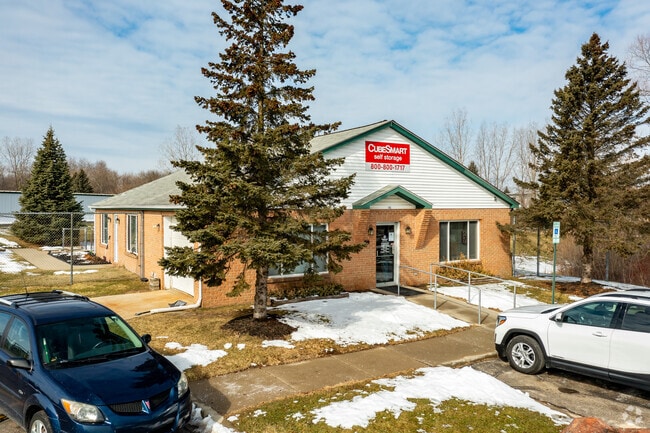
Property Record
1745 Waldon Rd, Lake Orion, MI 48359

NEARBY LISTINGS FOR SALE OR LEASE
Property Detail
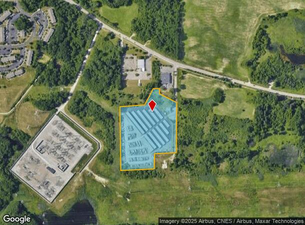
1745 Waldon Rd
09-28-251-012
T4N, R10E, SEC 28 PART OF NE 1/4 BEG AT PT DIST N 88-20-08 E 1270 FT & N 01-32-38 E 651.02 FT & S 88-20-08 W 250 FT FROM CEN
Officebuilding
Oakland
X
Michigan
26125C0357F
10.78 AC
2024
St Clair & Lapeer Counties
2025
Detroit
128700
Detroit-Warren-Dearborn, MI
93,950 SF
DEMOGRAPHICS near 1745 Waldon Rd
1 Mile
3 Mile
5 Mile
2024 Total Population
2,549
26,099
105,603
2029 Population
2,521
26,190
105,067
Pop Growth 2024-2029
(1.10%)
+ 0.35%
(0.51%)
Average Age
41
39
40
2024 Total Households
996
10,048
41,645
HH Growth 2024-2029
(1.20%)
+ 0.31%
(0.55%)
Median Household Inc
$80,837
$101,697
$88,187
Avg Household Size
2.50
2.50
2.50
2024 Avg HH Vehicles
2.00
2.00
2.00
Median Home Value
$210,513
$340,670
$334,282
Median Year Built
1972
1991
1985
Nearby Places
Map Layers
Map Styles
 Street
 Aerial
- Restaurants
- Banks
- Shops
- Fitness
- Groceries
PUBLIC TRANSPORTATION
COMMUTER RAIL
Pontiac Amtrak Station (Wolverine - Amtrak)
DRIVE
WALK
Distance
Pontiac Amtrak Station (Wolverine - Amtrak)
18 min
8.3 mi
AIRPORT
Bishop International
DRIVE
WALK
Distance
Bishop International
55 min
37.9 mi
Freight Ports
Port of Toledo
DRIVE
WALK
Distance
Port of Toledo
117 min
96.1 mi
Nearby Properties
Address
Land Use
TOTAL SIZE
Lot Size
Zoning
Address
Land Use
TOTAL SIZE
Lot Size
Zoning
6,255,758 SF
Address
Land Use
TOTAL SIZE
Lot Size
Zoning
1,421,000 SF
170.30 AC
B2
Address
Land Use
TOTAL SIZE
Lot Size
Zoning
527,000 SF
36.03 AC
Address
Land Use
TOTAL SIZE
Lot Size
Zoning
891,314 SF
60.90 AC
II
Address
Land Use
TOTAL SIZE
Lot Size
Zoning
420,858 SF
65.07 AC
Address
Land Use
TOTAL SIZE
Lot Size
Zoning
430,338 SF
46.09 AC
Address
Land Use
TOTAL SIZE
Lot Size
Zoning
247,500 SF
Address
Land Use
TOTAL SIZE
Lot Size
Zoning
6,255,758 SF
223.95 AC
Address
Land Use
TOTAL SIZE
Lot Size
Zoning
6,255,758 SF
233.05 AC
II
Address
Land Use
TOTAL SIZE
Lot Size
Zoning
246,150 SF
26.64 AC
TR
Address
Land Use
TOTAL SIZE
Lot Size
Zoning
6,255,758 SF
Address
Land Use
TOTAL SIZE
Lot Size
Zoning
430,338 SF
43.22 AC
Address
Land Use
TOTAL SIZE
Lot Size
Zoning
280,000 SF
Address
Land Use
TOTAL SIZE
Lot Size
Zoning
179,510 SF
8.80 AC
Address
Land Use
TOTAL SIZE
Lot Size
Zoning
213,112 SF
12.17 AC
I1
Address
Land Use
TOTAL SIZE
Lot Size
Zoning
347,979 SF
58.38 AC
AI
Address
Land Use
TOTAL SIZE
Lot Size
Zoning
329,335 SF
17.40 AC
Address
Land Use
TOTAL SIZE
Lot Size
Zoning
455,045 SF
23.47 AC
I1
Address
Land Use
TOTAL SIZE
Lot Size
Zoning
232,860 SF
28.30 AC
I1
Address
Land Use
TOTAL SIZE
Lot Size
Zoning
70,710 SF
13.38 AC
BI
Address
Land Use
TOTAL SIZE
Lot Size
Zoning
173,974 SF
31.37 AC
TR
Address
Land Use
TOTAL SIZE
Lot Size
Zoning
171,242 SF
11.86 AC
Address
Land Use
TOTAL SIZE
Lot Size
Zoning
137,086 SF
9.29 AC
I1
Address
Land Use
TOTAL SIZE
Lot Size
Zoning
172,412 SF
9.68 AC
I1
Address
Land Use
TOTAL SIZE
Lot Size
Zoning
245,436 SF
39.08 AC
Address
Land Use
TOTAL SIZE
Lot Size
Zoning
136,061 SF
14.64 AC
Address
Land Use
TOTAL SIZE
Lot Size
Zoning
218,870 SF
23.21 AC
Address
Land Use
TOTAL SIZE
Lot Size
Zoning
124,104 SF
Address
Land Use
TOTAL SIZE
Lot Size
Zoning
180,852 SF
40.32 AC
AI
Address
Land Use
TOTAL SIZE
Lot Size
Zoning
104,020 SF
6.48 AC
I2
The World's #1 Commercial Real Estate Marketplace
Connect with us
© 2026 CoStar Group
The information above has been obtained from sources believed reliable. While we do not doubt its accuracy we have not verified it and make no guarantee, warranty or representation about it. It is your responsibility to independently confirm its accuracy and completeness. Any projections, opinions, assumptions, or estimates used are for example only and do not represent the current or future performance of the property. The value of this transaction to you depends on tax and other factors which should be evaluated by your tax, financial, and legal advisors. You and your advisors should conduct a careful, independent investigation of the property to determine to your satisfaction the suitability of the property for your needs.