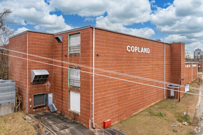
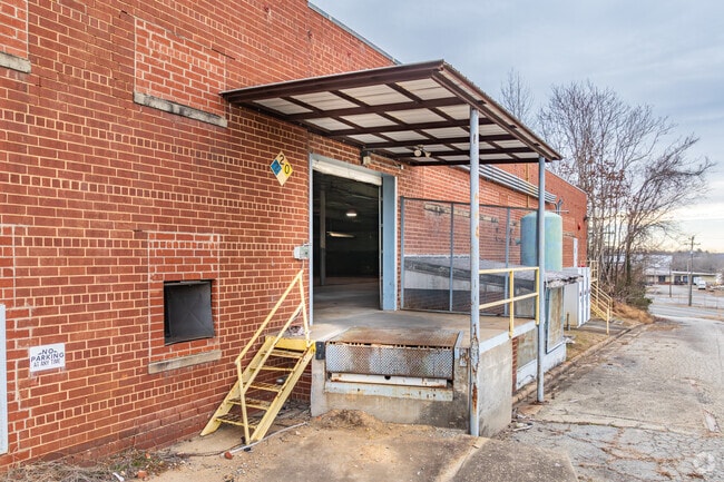
Property Record
1746 Carolina Mill Rd, Burlington, NC 27217
NEARBY LISTINGS FOR SALE OR LEASE
Property Detail
1746 Carolina Mill Rd
141255
CAROLINA MILL RD 5/20/2004
Manufacturinglight
Alamance
X
North Carolina
3710887600K
3.80 AC
2025
N Central Alamance County
2025
Greensboro/Winston-Salem
021400
Burlington, NC
182,826 SF
DEMOGRAPHICS near 1746 Carolina Mill Rd
1 Mile
3 Mile
5 Mile
2024 Total Population
1,617
29,481
75,636
2029 Population
1,766
32,004
81,744
Pop Growth 2024-2029
+ 9.21%
+ 8.56%
+ 8.08%
Average Age
38
38
39
2024 Total Households
617
11,248
30,061
HH Growth 2024-2029
+ 9.40%
+ 8.77%
+ 8.29%
Median Household Inc
$50,253
$40,357
$47,178
Avg Household Size
2.60
2.50
2.40
2024 Avg HH Vehicles
2.00
2.00
2.00
Median Home Value
$127,714
$113,366
$151,476
Median Year Built
1983
1970
1973
Nearby Places
Map Layers
Map Styles
 Street
 Aerial
- Restaurants
- Banks
- Shops
- Fitness
- Groceries
PUBLIC TRANSPORTATION
AIRPORT
Piedmont Triad International
DRIVE
WALK
Distance
Piedmont Triad International
57 min
37.2 mi
Freight Ports
Virginia Port Authority - Richmond
DRIVE
WALK
Distance
Virginia Port Authority - Richmond
212 min
176.7 mi
SALE & LEASE HISTORY
LISTING DATE
SALE/LEASE

Nov 15, 2023
For Sale
Jul 27, 2022
For Sale
Jan 25, 2022
For Sale
Dec 27, 2022
For Lease
Dec 13, 2019
For Sale
Dec 13, 2019
For Lease
Nearby Properties
Address
Land Use
TOTAL SIZE
Lot Size
Zoning
Address
Land Use
TOTAL SIZE
Lot Size
Zoning
40,220 SF
12.45 AC
MF A
Address
Land Use
TOTAL SIZE
Lot Size
Zoning
72,164 SF
73.50 AC
Address
Land Use
TOTAL SIZE
Lot Size
Zoning
110,612 SF
1 AC
B 3
Address
Land Use
TOTAL SIZE
Lot Size
Zoning
216,968 SF
25.50 AC
CB
Address
Land Use
TOTAL SIZE
Lot Size
Zoning
23,268 SF
6.11 AC
Address
Land Use
TOTAL SIZE
Lot Size
Zoning
2,923 SF
10.13 AC
Address
Land Use
TOTAL SIZE
Lot Size
Zoning
158,339 SF
16.34 AC
Address
Land Use
TOTAL SIZE
Lot Size
Zoning
77,046 SF
1.61 AC
I 3
Address
Land Use
TOTAL SIZE
Lot Size
Zoning
22,301 SF
19.25 AC
OI
Address
Land Use
TOTAL SIZE
Lot Size
Zoning
27,336 SF
10.84 AC
R 6
Address
Land Use
TOTAL SIZE
Lot Size
Zoning
41,787 SF
8.07 AC
COI
Address
Land Use
TOTAL SIZE
Lot Size
Zoning
25,200 SF
5.30 AC
Address
Land Use
TOTAL SIZE
Lot Size
Zoning
60,713 SF
3.15 AC
O I
Address
Land Use
TOTAL SIZE
Lot Size
Zoning
27,076 SF
10 AC
R 9
Address
Land Use
TOTAL SIZE
Lot Size
Zoning
50,549 SF
4.33 AC
OI
Address
Land Use
TOTAL SIZE
Lot Size
Zoning
6,152 SF
14 AC
R 6
Address
Land Use
TOTAL SIZE
Lot Size
Zoning
53,740 SF
30.43 AC
I 3
Address
Land Use
TOTAL SIZE
Lot Size
Zoning
5,984 SF
19.75 AC
Address
Land Use
TOTAL SIZE
Lot Size
Zoning
94,372 SF
7.13 AC
Address
Land Use
TOTAL SIZE
Lot Size
Zoning
18,932 SF
8.06 AC
R OI
Address
Land Use
TOTAL SIZE
Lot Size
Zoning
4,472 SF
8.07 AC
Address
Land Use
TOTAL SIZE
Lot Size
Zoning
435,030 SF
24.23 AC
I 3
Address
Land Use
TOTAL SIZE
Lot Size
Zoning
2,440 SF
16.01 AC
MF A
Address
Land Use
TOTAL SIZE
Lot Size
Zoning
50,895 SF
2.46 AC
O I
Address
Land Use
TOTAL SIZE
Lot Size
Zoning
39,170 SF
1.44 AC
MF B
Address
Land Use
TOTAL SIZE
Lot Size
Zoning
2,112 SF
12.03 AC
R 9
Address
Land Use
TOTAL SIZE
Lot Size
Zoning
2,824 SF
8.91 AC
MFA
Address
Land Use
TOTAL SIZE
Lot Size
Zoning
15,600 SF
3.28 AC
Address
Land Use
TOTAL SIZE
Lot Size
Zoning
106,210 SF
7.17 AC
I3
Address
Land Use
TOTAL SIZE
Lot Size
Zoning
37,450 SF
2.11 AC
R 9
The World's #1 Commercial Real Estate Marketplace
Connect with us
© 2025 CoStar Group
The information above has been obtained from sources believed reliable. While we do not doubt its accuracy we have not verified it and make no guarantee, warranty or representation about it. It is your responsibility to independently confirm its accuracy and completeness. Any projections, opinions, assumptions, or estimates used are for example only and do not represent the current or future performance of the property. The value of this transaction to you depends on tax and other factors which should be evaluated by your tax, financial, and legal advisors. You and your advisors should conduct a careful, independent investigation of the property to determine to your satisfaction the suitability of the property for your needs.