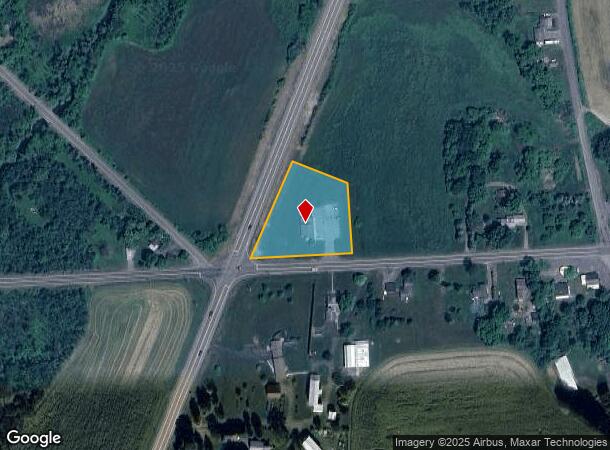
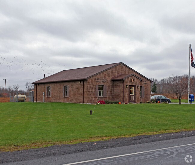
Property Record
1749 State Route 173, Memphis, NY 13112

NEARBY LISTINGS FOR SALE OR LEASE
-
-
View all Memphis listings for sale on LoopNet.com
Property Detail
1749 State Route 173
315689-049-000-0001-005-002-0000
FL 25 MEMPHIS POST OFFICE BLD
Storesoffices
Onondaga
X
New York
36067C0157F
5.002
2025
1.20 AC
2024
W Outer Onondaga County
011900
Syracuse
1,781 SF
Syracuse, NY
DEMOGRAPHICS near 1749 State Route 173
1 Mile
3 Mile
5 Mile
2024 Total Population
267
2,887
20,209
2029 Population
259
2,809
19,701
Pop Growth 2024-2029
(3.00%)
(2.70%)
(2.51%)
Average Age
44
44
44
2024 Total Households
95
1,099
8,622
HH Growth 2024-2029
(3.16%)
(2.91%)
(2.70%)
Median Household Inc
$79,375
$78,797
$69,282
Avg Household Size
2.70
2.60
2.30
2024 Avg HH Vehicles
2.00
2.00
2.00
Median Home Value
$164,655
$176,086
$176,446
Median Year Built
1947
1954
1972
Nearby Places
- Restaurants
- Banks
- Shops
- Fitness
- Groceries
PUBLIC TRANSPORTATION
AIRPORT
Syracuse Hancock International
DRIVE
WALK
Distance
Syracuse Hancock International
29 min
17.6 mi
Freight Ports
Albany, NY Port
DRIVE
WALK
Distance
Albany, NY Port
188 min
156.8 mi
Nearby Properties
Address
Land Use
TOTAL SIZE
Lot Size
Zoning
Address
Land Use
TOTAL SIZE
Lot Size
Zoning
359,422 SF
25.50 AC
INA
Address
Land Use
TOTAL SIZE
Lot Size
Zoning
69.49 AC
02
Address
Land Use
TOTAL SIZE
Lot Size
Zoning
22.43 AC
Address
Land Use
TOTAL SIZE
Lot Size
Zoning
28.81 AC
08 - GOVER
Address
Land Use
TOTAL SIZE
Lot Size
Zoning
24.77 AC
08 - GOVER
Address
Land Use
TOTAL SIZE
Lot Size
Zoning
20.63 AC
Address
Land Use
TOTAL SIZE
Lot Size
Zoning
67.34 AC
A80
Address
Land Use
TOTAL SIZE
Lot Size
Zoning
178.32 AC
02 - SINGL
Address
Land Use
TOTAL SIZE
Lot Size
Zoning
8,408 SF
0.72 AC
03 - MULTI
Address
Land Use
TOTAL SIZE
Lot Size
Zoning
11.29 AC
06 - INDUS
Address
Land Use
TOTAL SIZE
Lot Size
Zoning
3,200 SF
11.09 AC
RHD
Address
Land Use
TOTAL SIZE
Lot Size
Zoning
480 SF
04 - FARM
Address
Land Use
TOTAL SIZE
Lot Size
Zoning
104.69 AC
02 - SINGL
Address
Land Use
TOTAL SIZE
Lot Size
Zoning
3,620 SF
1.67 AC
06 - INDUS
Address
Land Use
TOTAL SIZE
Lot Size
Zoning
120 SF
2.07 AC
A80
Address
Land Use
TOTAL SIZE
Lot Size
Zoning
920 SF
15.15 AC
03 - MULTI
Address
Land Use
TOTAL SIZE
Lot Size
Zoning
3,910 SF
3.24 AC
A80
Address
Land Use
TOTAL SIZE
Lot Size
Zoning
132.43 AC
A80
Address
Land Use
TOTAL SIZE
Lot Size
Zoning
6,328 SF
2.40 AC
05 - COMME
Address
Land Use
TOTAL SIZE
Lot Size
Zoning
90.91 AC
03 - MULTI
Address
Land Use
TOTAL SIZE
Lot Size
Zoning
2,508 SF
0.46 AC
RHD
Address
Land Use
TOTAL SIZE
Lot Size
Zoning
4,000 SF
1.57 AC
R20
Address
Land Use
TOTAL SIZE
Lot Size
Zoning
47.91 AC
A80
Address
Land Use
TOTAL SIZE
Lot Size
Zoning
3.37 AC
06 - INDUS
Address
Land Use
TOTAL SIZE
Lot Size
Zoning
80.80 AC
02 - SINGL
Address
Land Use
TOTAL SIZE
Lot Size
Zoning
108.19 AC
04 - FARM
Address
Land Use
TOTAL SIZE
Lot Size
Zoning
2,016 SF
59.89 AC
A80
Address
Land Use
TOTAL SIZE
Lot Size
Zoning
5,645 SF
1.14 AC
05 - COMME
Address
Land Use
TOTAL SIZE
Lot Size
Zoning
2,600 SF
33.19 AC
04 - FARM
The World's #1 Commercial Real Estate Marketplace
Connect with us
© 2025 CoStar Group
The information above has been obtained from sources believed reliable. While we do not doubt its accuracy we have not verified it and make no guarantee, warranty or representation about it. It is your responsibility to independently confirm its accuracy and completeness. Any projections, opinions, assumptions, or estimates used are for example only and do not represent the current or future performance of the property. The value of this transaction to you depends on tax and other factors which should be evaluated by your tax, financial, and legal advisors. You and your advisors should conduct a careful, independent investigation of the property to determine to your satisfaction the suitability of the property for your needs.