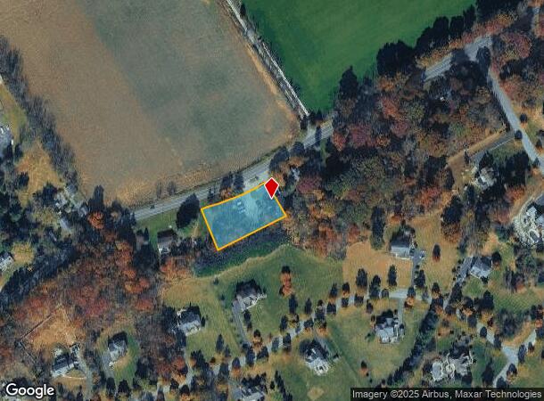
Property Record
175 Anderson Rd, Asbury, NJ 08802
NEARBY LISTINGS FOR SALE OR LEASE
Property Detail
175 Anderson Rd
05-00051-02-00016-02
Warren
Vacantlandnec
New Jersey
X
16.2
34041C0328E
0.73 AC
2024
Warren County
2025
Northern New Jersey
372900
Allentown-Bethlehem-Easton, PA-NJ
DEMOGRAPHICS near 175 Anderson Rd
1 Mile
3 Mile
5 Mile
2024 Total Population
530
8,056
26,016
2029 Population
539
8,216
26,404
Pop Growth 2024-2029
+ 1.70%
+ 1.99%
+ 1.49%
Average Age
44
44
44
2024 Total Households
197
3,250
9,974
HH Growth 2024-2029
+ 2.03%
+ 1.94%
+ 1.51%
Median Household Inc
$108,333
$102,614
$95,868
Avg Household Size
2.60
2.50
2.50
2024 Avg HH Vehicles
3.00
2.00
2.00
Median Home Value
$402,500
$359,102
$339,097
Median Year Built
1975
1976
1972
Nearby Places
Map Layers
Map Styles
 Street
 Aerial
- Restaurants
- Banks
- Shops
- Fitness
- Groceries
PUBLIC TRANSPORTATION
COMMUTER RAIL
High Bridge (Raritan Valley Line - NJ Transit Commuter Rail (NJ Transit))
DRIVE
WALK
Distance
High Bridge (Raritan Valley Line - NJ Transit Commuter Rail (NJ Transit))
12 min
9.0 mi
AIRPORT
Lehigh Valley International
DRIVE
WALK
Distance
Lehigh Valley International
47 min
28.1 mi
Freight Ports
New York Container Terminal
DRIVE
WALK
Distance
New York Container Terminal
72 min
55.1 mi
Nearby Properties
Address
Land Use
TOTAL SIZE
Lot Size
Zoning
Address
Land Use
TOTAL SIZE
Lot Size
Zoning
52.10 AC
PCOS
Address
Land Use
TOTAL SIZE
Lot Size
Zoning
Address
Land Use
TOTAL SIZE
Lot Size
Zoning
77.78 AC
ED
Address
Land Use
TOTAL SIZE
Lot Size
Zoning
29.81 AC
HC
Address
Land Use
TOTAL SIZE
Lot Size
Zoning
800 SF
28.04 AC
MR
Address
Land Use
TOTAL SIZE
Lot Size
Zoning
22.84 AC
HC
Address
Land Use
TOTAL SIZE
Lot Size
Zoning
17.20 AC
IP
Address
Land Use
TOTAL SIZE
Lot Size
Zoning
20.43 AC
R4
Address
Land Use
TOTAL SIZE
Lot Size
Zoning
11.15 AC
MFG
Address
Land Use
TOTAL SIZE
Lot Size
Zoning
6.24 AC
PVD
Address
Land Use
TOTAL SIZE
Lot Size
Zoning
3.98 AC
B-4
Address
Land Use
TOTAL SIZE
Lot Size
Zoning
8.97 AC
Address
Land Use
TOTAL SIZE
Lot Size
Zoning
Address
Land Use
TOTAL SIZE
Lot Size
Zoning
1,280 SF
240.85 AC
PVD
Address
Land Use
TOTAL SIZE
Lot Size
Zoning
1.87 AC
PVD
Address
Land Use
TOTAL SIZE
Lot Size
Zoning
5.40 AC
OR
Address
Land Use
TOTAL SIZE
Lot Size
Zoning
5.50 AC
OR
Address
Land Use
TOTAL SIZE
Lot Size
Zoning
5.08 AC
HC
Address
Land Use
TOTAL SIZE
Lot Size
Zoning
5,752 SF
2.09 AC
RA
Address
Land Use
TOTAL SIZE
Lot Size
Zoning
203 AC
MR
Address
Land Use
TOTAL SIZE
Lot Size
Zoning
6.04 AC
HC
Address
Land Use
TOTAL SIZE
Lot Size
Zoning
1.98 AC
PVD
Address
Land Use
TOTAL SIZE
Lot Size
Zoning
1.70 AC
HC
Address
Land Use
TOTAL SIZE
Lot Size
Zoning
7,500 SF
6.05 AC
HC
Address
Land Use
TOTAL SIZE
Lot Size
Zoning
8,218 SF
1 AC
RC
Address
Land Use
TOTAL SIZE
Lot Size
Zoning
3 AC
B-2
Address
Land Use
TOTAL SIZE
Lot Size
Zoning
11,220 SF
4.06 AC
GA
Address
Land Use
TOTAL SIZE
Lot Size
Zoning
1.89 AC
HC
Address
Land Use
TOTAL SIZE
Lot Size
Zoning
5,720 SF
17.47 AC
OR
Address
Land Use
TOTAL SIZE
Lot Size
Zoning
2,831 SF
4.95 AC
HC
The World's #1 Commercial Real Estate Marketplace
Connect with us
© 2025 CoStar Group
The information above has been obtained from sources believed reliable. While we do not doubt its accuracy we have not verified it and make no guarantee, warranty or representation about it. It is your responsibility to independently confirm its accuracy and completeness. Any projections, opinions, assumptions, or estimates used are for example only and do not represent the current or future performance of the property. The value of this transaction to you depends on tax and other factors which should be evaluated by your tax, financial, and legal advisors. You and your advisors should conduct a careful, independent investigation of the property to determine to your satisfaction the suitability of the property for your needs.