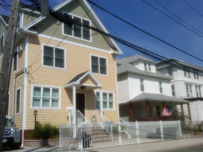
Property Record
175 Beach 113Th St, Rockaway Park, NY 11694

Save to a Folder
{{folder.Name}}
{{folder.ListingIds.length}} Properties
{{folder.ListingIds.length}} Property
Create a New Folder
This Property Is For Sale
Property Detail
175 Beach 113Th St
16186-0021
Queens
Multifamilydwelling
New York
R5A
17
B and X Area of moderate flood hazard, usually the area between the limits of the 100-year and 500-year floods.
0.09 AC
2025
Rockaway Park
2026
Long Island (New York)
093401
New York-Jersey City-White Plains, NY-NJ
2,600 SF
NEARBY LISTINGS FOR SALE OR LEASE
-
-
-
-
No Photo
-
-
-
-
View all Rockaway Park listings for sale on LoopNet.com
DEMOGRAPHICS near 175 Beach 113Th St
1 mile
3 mile
5 mile
2025 Total Population
17,986
57,355
164,474
2030 Population
18,192
57,419
163,493
Pop Growth 2025-2030
+ 1.15%
+ 0.11%
(0.60%)
Average Age
46
43
42
2025 Total Households
7,194
21,260
57,043
HH Growth 2025-2030
+ 0.61%
(0.42%)
(1.03%)
Median Household Inc
$90,193
$65,815
$66,656
Avg Household Size
2.20
2.50
2.60
2025 Avg HH Vehicles
1.00
1.00
1.00
Median Home Value
$675,441
$662,732
$725,115
Median Year Built
1963
1964
1964
Nearby Places
Map Layers
Map Styles
 Street
 Aerial
Layers
 Traffic
 Biking
Places
Listings with unknown addresses are not visible on the map
- Restaurants
- Banks
- Shops
- Fitness
- Groceries
PUBLIC TRANSPORTATION
TRANSIT/SUBWAY
Rockaway Park-Beach 116 Street (A - New York MTA Subway (The Subway), Rockaway Park Shuttle - New York MTA Subway (The Subway))
Drive
Walk
Distance
Rockaway Park-Beach 116 Street (A - New York MTA Subway (The Subway), Rockaway Park Shuttle - New York MTA Subway (The Subway))
2 min
10 min
0.5 mi
Beach 105 Street (A - New York MTA Subway (The Subway), Rockaway Park Shuttle - New York MTA Subway (The Subway))
Drive
Walk
Distance
Beach 105 Street (A - New York MTA Subway (The Subway), Rockaway Park Shuttle - New York MTA Subway (The Subway))
2 min
10 min
0.5 mi
Beach 98 Street (A - New York MTA Subway (The Subway), Rockaway Park Shuttle - New York MTA Subway (The Subway))
Drive
Walk
Distance
Beach 98 Street (A - New York MTA Subway (The Subway), Rockaway Park Shuttle - New York MTA Subway (The Subway))
3 min
18 min
0.9 mi
COMMUTER RAIL
Far Rockaway Station (Far Rockaway Branch - Long Island Rail Road)
Drive
Walk
Distance
Far Rockaway Station (Far Rockaway Branch - Long Island Rail Road)
16 min
5.4 mi
Inwood Station (Far Rockaway Branch - Long Island Rail Road)
Drive
Walk
Distance
Inwood Station (Far Rockaway Branch - Long Island Rail Road)
17 min
6.8 mi
AIRPORT
John F Kennedy International
Drive
Walk
Distance
John F Kennedy International
24 min
11.7 mi
LaGuardia
Drive
Walk
Distance
LaGuardia
35 min
18.5 mi
Newark Liberty International
Drive
Walk
Distance
Newark Liberty International
54 min
32.9 mi
Freight Ports
NY - Red Hook Container Terminal
Drive
Walk
Distance
NY - Red Hook Container Terminal
32 min
15.4 mi
Nearby Properties
Address
Land Use
TOTAL SIZE
Lot Size
Zoning
Address
Land Use
TOTAL SIZE
Lot Size
Zoning
72,663 SF
264.48 AC
PARK
Address
Land Use
TOTAL SIZE
Lot Size
Zoning
65.94 AC
PARKUS
Address
Land Use
TOTAL SIZE
Lot Size
Zoning
200.83 AC
PARK
Address
Land Use
TOTAL SIZE
Lot Size
Zoning
50,000 SF
149.22 AC
PARK
Address
Land Use
TOTAL SIZE
Lot Size
Zoning
2,000 SF
253.68 AC
R4
Address
Land Use
TOTAL SIZE
Lot Size
Zoning
42.84 AC
PARK
Address
Land Use
TOTAL SIZE
Lot Size
Zoning
1,085,148 SF
13.53 AC
R6
Address
Land Use
TOTAL SIZE
Lot Size
Zoning
169.01 AC
PARK
Address
Land Use
TOTAL SIZE
Lot Size
Zoning
407,218 SF
34.48 AC
R4
Address
Land Use
TOTAL SIZE
Lot Size
Zoning
81.43 AC
PARK
Address
Land Use
TOTAL SIZE
Lot Size
Zoning
820,910 SF
21.03 AC
R4
Address
Land Use
TOTAL SIZE
Lot Size
Zoning
32.47 AC
PARK
Address
Land Use
TOTAL SIZE
Lot Size
Zoning
20,000 SF
172.95 AC
PARK
Address
Land Use
TOTAL SIZE
Lot Size
Zoning
17.68 AC
PARK
Address
Land Use
TOTAL SIZE
Lot Size
Zoning
18.71 AC
PARKUS
Address
Land Use
TOTAL SIZE
Lot Size
Zoning
1,800 SF
65.66 AC
PARK
Address
Land Use
TOTAL SIZE
Lot Size
Zoning
587,170 SF
13.55 AC
R4
Address
Land Use
TOTAL SIZE
Lot Size
Zoning
72,148 SF
0.44 AC
R6A
Address
Land Use
TOTAL SIZE
Lot Size
Zoning
666,256 SF
14.16 AC
R6
Address
Land Use
TOTAL SIZE
Lot Size
Zoning
128,000 SF
2.52 AC
R5
Address
Land Use
TOTAL SIZE
Lot Size
Zoning
3,120 SF
20.62 AC
PARK
Address
Land Use
TOTAL SIZE
Lot Size
Zoning
145,883 SF
1.29 AC
R6
Address
Land Use
TOTAL SIZE
Lot Size
Zoning
120,994 SF
1.71 AC
R6
Address
Land Use
TOTAL SIZE
Lot Size
Zoning
358,140 SF
8.13 AC
R5
Address
Land Use
TOTAL SIZE
Lot Size
Zoning
168,630 SF
1.26 AC
M1-2
Address
Land Use
TOTAL SIZE
Lot Size
Zoning
119,875 SF
3.16 AC
R4
Address
Land Use
TOTAL SIZE
Lot Size
Zoning
141,010 SF
0.59 AC
M1-3
Address
Land Use
TOTAL SIZE
Lot Size
Zoning
102,204 SF
2.32 AC
R6
Address
Land Use
TOTAL SIZE
Lot Size
Zoning
13.76 AC
PARK
Address
Land Use
TOTAL SIZE
Lot Size
Zoning
293,677 SF
4.48 AC
R5
The World's #1 Commercial Real Estate Marketplace
Connect with us
© 2026 CoStar Group
The information above has been obtained from sources believed reliable. While we do not doubt its accuracy we have not verified it and make no guarantee, warranty or representation about it. It is your responsibility to independently confirm its accuracy and completeness. Any projections, opinions, assumptions, or estimates used are for example only and do not represent the current or future performance of the property. The value of this transaction to you depends on tax and other factors which should be evaluated by your tax, financial, and legal advisors. You and your advisors should conduct a careful, independent investigation of the property to determine to your satisfaction the suitability of the property for your needs.