Property Record
175 Brushy Plain Rd, Branford, CT 06405
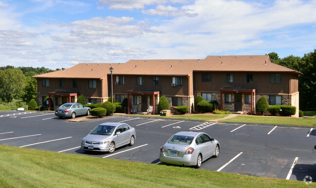


Property Detail
175 Brushy Plain Rd
New Haven, CT
South Central Ct
BRAN-000004D-000002-000041
Connecticut
Apartmenthouse5plusunits
41
B and X Area of moderate flood hazard, usually the area between the limits of the 100-year and 500-year floods.
9.15 AC
2025
Branford
2025
Westchester/So Connecticut
184700
NEARBY LISTINGS FOR SALE OR LEASE
-
-
View all Branford listings for sale on LoopNet.com
DEMOGRAPHICS near 175 Brushy Plain Rd
1 mile
3 mile
5 mile
2025 Total Population
3,900
45,012
117,931
2030 Population
3,961
46,076
119,165
Pop Growth 2025-2030
+ 1.56%
+ 2.36%
+ 1.05%
Average Age
45
46
43
2025 Total Households
1,664
20,377
49,036
HH Growth 2025-2030
+ 1.44%
+ 2.65%
+ 1.30%
Median Household Inc
$99,563
$80,308
$74,965
Avg Household Size
2.30
2.20
2.30
2025 Avg HH Vehicles
2.00
2.00
2.00
Median Home Value
$381,737
$350,423
$336,401
Median Year Built
1982
1975
1967
Nearby Places
Map Layers
Map Styles
 Street
 Aerial
Transit
 Traffic
 Biking
Places
Listings with unknown addresses are not visible on the map
- Restaurants
- Banks
- Shops
- Fitness
- Groceries
PUBLIC TRANSPORTATION
COMMUTER RAIL
Branford (Commuter Rail - Shore Line East, Shore Line East - Shore Line East)
Drive
Walk
Distance
Branford (Commuter Rail - Shore Line East, Shore Line East - Shore Line East)
6 min
2.3 mi
New Haven-State Street Station (Hartford Line - CONN DOT, New Haven Line - CONN DOT, Shore Line East - CONN DOT)
Drive
Walk
Distance
New Haven-State Street Station (Hartford Line - CONN DOT, New Haven Line - CONN DOT, Shore Line East - CONN DOT)
12 min
7.2 mi
AIRPORT
Tweed/New Haven
Drive
Walk
Distance
Tweed/New Haven
11 min
5.5 mi
Freight Ports
Port of New Haven
Drive
Walk
Distance
Port of New Haven
11 min
6.1 mi
Nearby Properties
Address
Land Use
TOTAL SIZE
Lot Size
Zoning
Address
Land Use
TOTAL SIZE
Lot Size
Zoning
227,335 SF
38.50 AC
Address
Land Use
TOTAL SIZE
Lot Size
Zoning
50.70 AC
R40
Address
Land Use
TOTAL SIZE
Lot Size
Zoning
54 AC
R-3
Address
Land Use
TOTAL SIZE
Lot Size
Zoning
175,913 SF
29 AC
Address
Land Use
TOTAL SIZE
Lot Size
Zoning
7,065 SF
9.44 AC
Address
Land Use
TOTAL SIZE
Lot Size
Zoning
132,592 SF
4.61 AC
PDD 23
Address
Land Use
TOTAL SIZE
Lot Size
Zoning
5,946 SF
0.09 AC
RM1
Address
Land Use
TOTAL SIZE
Lot Size
Zoning
306,943 SF
1.92 AC
PDD 23
Address
Land Use
TOTAL SIZE
Lot Size
Zoning
16.50 AC
Address
Land Use
TOTAL SIZE
Lot Size
Zoning
5.50 AC
Address
Land Use
TOTAL SIZE
Lot Size
Zoning
249,513 SF
6.57 AC
PDD 23
Address
Land Use
TOTAL SIZE
Lot Size
Zoning
35 AC
RA-1
Address
Land Use
TOTAL SIZE
Lot Size
Zoning
44,676 SF
7 AC
Address
Land Use
TOTAL SIZE
Lot Size
Zoning
276,776 SF
4.98 AC
PDD 23
Address
Land Use
TOTAL SIZE
Lot Size
Zoning
2,299 SF
14.94 AC
RA-1
Address
Land Use
TOTAL SIZE
Lot Size
Zoning
19.26 AC
R-2
Address
Land Use
TOTAL SIZE
Lot Size
Zoning
70,417 SF
7 AC
R40
Address
Land Use
TOTAL SIZE
Lot Size
Zoning
10,892 SF
5.05 AC
Address
Land Use
TOTAL SIZE
Lot Size
Zoning
99,965 SF
9.11 AC
PEFD
Address
Land Use
TOTAL SIZE
Lot Size
Zoning
34,341 SF
5.65 AC
Address
Land Use
TOTAL SIZE
Lot Size
Zoning
10.30 AC
B1
Address
Land Use
TOTAL SIZE
Lot Size
Zoning
14,508 SF
14 AC
Address
Land Use
TOTAL SIZE
Lot Size
Zoning
5,089 SF
25.20 AC
R18
Address
Land Use
TOTAL SIZE
Lot Size
Zoning
20.90 AC
Address
Land Use
TOTAL SIZE
Lot Size
Zoning
4.87 AC
Address
Land Use
TOTAL SIZE
Lot Size
Zoning
124,472 SF
16.60 AC
Address
Land Use
TOTAL SIZE
Lot Size
Zoning
94,311 SF
6.80 AC
Address
Land Use
TOTAL SIZE
Lot Size
Zoning
124,577 SF
15.83 AC
CD
Address
Land Use
TOTAL SIZE
Lot Size
Zoning
6,480 SF
15.94 AC
Address
Land Use
TOTAL SIZE
Lot Size
Zoning
14,030 SF
13.20 AC
The World's #1 Commercial Real Estate Marketplace
Connect with us
© 2026 CoStar Group
The information above has been obtained from sources believed reliable. While we do not doubt its accuracy we have not verified it and make no guarantee, warranty or representation about it. It is your responsibility to independently confirm its accuracy and completeness. Any projections, opinions, assumptions, or estimates used are for example only and do not represent the current or future performance of the property. The value of this transaction to you depends on tax and other factors which should be evaluated by your tax, financial, and legal advisors. You and your advisors should conduct a careful, independent investigation of the property to determine to your satisfaction the suitability of the property for your needs.