Property Record
175 Danielson Pike, Foster, RI 02825
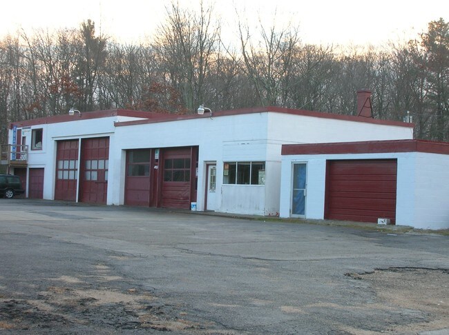

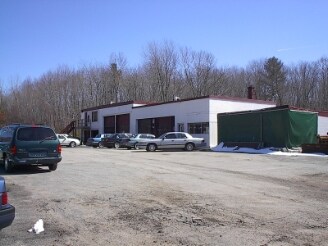
Property Detail
175 Danielson Pike
FOST-000010-000000-000081
Providence
Commercialnec
Rhode Island
1
81
A Areas with a 1% annual chance of flooding and a 26% chance of flooding over the life of a 30-year mortgage.
3.70 AC
2025
Foster/Scituate
2025
Providence
013300
Providence-Warwick, RI-MA
5,154 SF
NEARBY LISTINGS FOR SALE OR LEASE
-
-
View all Foster listings for sale on LoopNet.com
DEMOGRAPHICS near 175 Danielson Pike
1 mile
3 mile
5 mile
2025 Total Population
191
2,997
9,237
2030 Population
194
3,037
9,402
Pop Growth 2025-2030
+ 1.57%
+ 1.33%
+ 1.79%
Average Age
45
45
45
2025 Total Households
75
1,177
3,667
HH Growth 2025-2030
+ 1.33%
+ 1.36%
+ 1.80%
Median Household Inc
$122,793
$109,915
$104,445
Avg Household Size
2.50
2.50
2.50
2025 Avg HH Vehicles
2.00
2.00
2.00
Median Home Value
$420,000
$392,831
$366,989
Median Year Built
1974
1976
1978
Nearby Places
Map Layers
Map Styles
 Street
 Aerial
Layers
 Traffic
 Biking
Places
Listings with unknown addresses are not visible on the map
- Restaurants
- Banks
- Shops
- Fitness
- Groceries
PUBLIC TRANSPORTATION
AIRPORT
Rhode Island Tf Green International
Drive
Walk
Distance
Rhode Island Tf Green International
35 min
25.5 mi
Freight Ports
Port of Davisville, RI
Drive
Walk
Distance
Port of Davisville, RI
46 min
34.8 mi
SALE & LEASE HISTORY
LISTING DATE
SALE/LEASE

Jun 05, 2017
For Sale
Nearby Properties
Address
Land Use
TOTAL SIZE
Lot Size
Zoning
Address
Land Use
TOTAL SIZE
Lot Size
Zoning
50,170 SF
17.22 AC
30
Address
Land Use
TOTAL SIZE
Lot Size
Zoning
6,250 SF
225 AC
RD
Address
Land Use
TOTAL SIZE
Lot Size
Zoning
Address
Land Use
TOTAL SIZE
Lot Size
Zoning
4,528 SF
7.10 AC
1
Address
Land Use
TOTAL SIZE
Lot Size
Zoning
6,820 SF
4.56 AC
20
Address
Land Use
TOTAL SIZE
Lot Size
Zoning
9,828 SF
10.16 AC
1
Address
Land Use
TOTAL SIZE
Lot Size
Zoning
10,545 SF
23 AC
30
Address
Land Use
TOTAL SIZE
Lot Size
Zoning
1,161 SF
6.10 AC
1
Address
Land Use
TOTAL SIZE
Lot Size
Zoning
1,696 SF
5 AC
1
Address
Land Use
TOTAL SIZE
Lot Size
Zoning
1,638 SF
2.75 AC
30
Address
Land Use
TOTAL SIZE
Lot Size
Zoning
1,728 SF
13.01 AC
1
Address
Land Use
TOTAL SIZE
Lot Size
Zoning
4,208 SF
0.50 AC
30
Address
Land Use
TOTAL SIZE
Lot Size
Zoning
8,628 SF
4.40 AC
RD
Address
Land Use
TOTAL SIZE
Lot Size
Zoning
2,016 SF
15.69 AC
30
Address
Land Use
TOTAL SIZE
Lot Size
Zoning
768 SF
5.30 AC
1
Address
Land Use
TOTAL SIZE
Lot Size
Zoning
2,286 SF
40.04 AC
30
Address
Land Use
TOTAL SIZE
Lot Size
Zoning
1,184 SF
2 AC
1
Address
Land Use
TOTAL SIZE
Lot Size
Zoning
1,793 SF
1 AC
1
Address
Land Use
TOTAL SIZE
Lot Size
Zoning
1,386 SF
0.62 AC
1
Address
Land Use
TOTAL SIZE
Lot Size
Zoning
3,012 SF
4.59 AC
30
Address
Land Use
TOTAL SIZE
Lot Size
Zoning
552 SF
2.30 AC
1
Address
Land Use
TOTAL SIZE
Lot Size
Zoning
6,863 SF
23.09 AC
30
Address
Land Use
TOTAL SIZE
Lot Size
Zoning
10,000 SF
13.46 AC
1
Address
Land Use
TOTAL SIZE
Lot Size
Zoning
30.98 AC
1
Address
Land Use
TOTAL SIZE
Lot Size
Zoning
1,920 SF
16.43 AC
30
Address
Land Use
TOTAL SIZE
Lot Size
Zoning
1,182 SF
1.50 AC
30
Address
Land Use
TOTAL SIZE
Lot Size
Zoning
2,964 SF
11 AC
1
Address
Land Use
TOTAL SIZE
Lot Size
Zoning
1,486 SF
42.78 AC
RD
Address
Land Use
TOTAL SIZE
Lot Size
Zoning
1,140 SF
4.33 AC
1
Address
Land Use
TOTAL SIZE
Lot Size
Zoning
1,547 SF
25 AC
30
The World's #1 Commercial Real Estate Marketplace
Connect with us
© 2026 CoStar Group
The information above has been obtained from sources believed reliable. While we do not doubt its accuracy we have not verified it and make no guarantee, warranty or representation about it. It is your responsibility to independently confirm its accuracy and completeness. Any projections, opinions, assumptions, or estimates used are for example only and do not represent the current or future performance of the property. The value of this transaction to you depends on tax and other factors which should be evaluated by your tax, financial, and legal advisors. You and your advisors should conduct a careful, independent investigation of the property to determine to your satisfaction the suitability of the property for your needs.