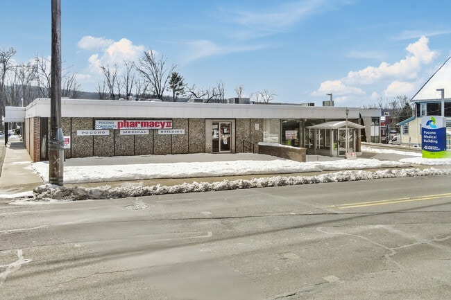
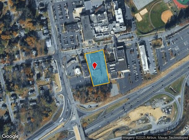
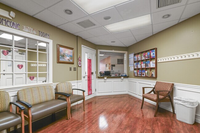
Property Record
175 E Brown St, East Stroudsburg, PA 18301
NEARBY LISTINGS FOR SALE OR LEASE
Property Detail
175 E Brown St
Medicalbuilding
Monroe
X
Pennsylvania
42095C0035E
1.12 AC
2025
Monroe County
2025
Philadelphia
300700
East Stroudsburg, PA
15,776 SF
05-1.3.3.5
DEMOGRAPHICS near 175 E Brown St
1 Mile
3 Mile
5 Mile
2024 Total Population
7,469
26,170
43,045
2029 Population
7,271
25,733
42,597
Pop Growth 2024-2029
(2.65%)
(1.67%)
(1.04%)
Average Age
37
41
41
2024 Total Households
2,601
9,912
15,906
HH Growth 2024-2029
(2.04%)
(1.46%)
(0.84%)
Median Household Inc
$59,132
$66,371
$78,155
Avg Household Size
2.20
2.40
2.50
2024 Avg HH Vehicles
2.00
2.00
2.00
Median Home Value
$188,851
$234,768
$242,013
Median Year Built
1952
1973
1980
Nearby Places
- Restaurants
- Banks
- Shops
- Fitness
- Groceries
PUBLIC TRANSPORTATION
AIRPORT
Lehigh Valley International
DRIVE
WALK
Distance
Lehigh Valley International
51 min
33.4 mi
Freight Ports
Maher Terminal
DRIVE
WALK
Distance
Maher Terminal
87 min
69.1 mi
SALE & LEASE HISTORY
LISTING DATE
SALE/LEASE

Apr 19, 2024
For Sale
Nearby Properties
Address
Land Use
TOTAL SIZE
Lot Size
Zoning
Address
Land Use
TOTAL SIZE
Lot Size
Zoning
412,170 SF
Address
Land Use
TOTAL SIZE
Lot Size
Zoning
260,728 SF
23.15 AC
IU
Address
Land Use
TOTAL SIZE
Lot Size
Zoning
225,935 SF
3.74 AC
IM
Address
Land Use
TOTAL SIZE
Lot Size
Zoning
102,240 SF
34.13 AC
R-2
Address
Land Use
TOTAL SIZE
Lot Size
Zoning
254,320 SF
0.23 AC
IU
Address
Land Use
TOTAL SIZE
Lot Size
Zoning
16,664 SF
43.49 AC
R2
Address
Land Use
TOTAL SIZE
Lot Size
Zoning
48,796 SF
5.69 AC
C-1A
Address
Land Use
TOTAL SIZE
Lot Size
Zoning
91,431 SF
Address
Land Use
TOTAL SIZE
Lot Size
Zoning
112,582 SF
26.38 AC
B2
Address
Land Use
TOTAL SIZE
Lot Size
Zoning
140,177 SF
16.16 AC
C-1
Address
Land Use
TOTAL SIZE
Lot Size
Zoning
64,736 SF
1.53 AC
MU-B
Address
Land Use
TOTAL SIZE
Lot Size
Zoning
129,257 SF
1.92 AC
IU
Address
Land Use
TOTAL SIZE
Lot Size
Zoning
126,740 SF
1.67 AC
IU
Address
Land Use
TOTAL SIZE
Lot Size
Zoning
90,072 SF
3.15 AC
IU
Address
Land Use
TOTAL SIZE
Lot Size
Zoning
216 SF
109.59 AC
S-1
Address
Land Use
TOTAL SIZE
Lot Size
Zoning
20,984 SF
14.30 AC
I-E
Address
Land Use
TOTAL SIZE
Lot Size
Zoning
201,578 SF
21.19 AC
OM-1
Address
Land Use
TOTAL SIZE
Lot Size
Zoning
83,103 SF
30.80 AC
IU
Address
Land Use
TOTAL SIZE
Lot Size
Zoning
47,628 SF
4.40 AC
C1
Address
Land Use
TOTAL SIZE
Lot Size
Zoning
3,864 SF
195.93 AC
R1
Address
Land Use
TOTAL SIZE
Lot Size
Zoning
34,352 SF
9.83 AC
C1
Address
Land Use
TOTAL SIZE
Lot Size
Zoning
113,052 SF
1.56 AC
C-2
Address
Land Use
TOTAL SIZE
Lot Size
Zoning
179,576 SF
1.76 AC
C-2
Address
Land Use
TOTAL SIZE
Lot Size
Zoning
40,978 SF
0.45 AC
C1
Address
Land Use
TOTAL SIZE
Lot Size
Zoning
8,740 SF
9.25 AC
R-2
Address
Land Use
TOTAL SIZE
Lot Size
Zoning
52,322 SF
2.93 AC
C-2
Address
Land Use
TOTAL SIZE
Lot Size
Zoning
30,622 SF
3.55 AC
C1
Address
Land Use
TOTAL SIZE
Lot Size
Zoning
9,916 SF
9.63 AC
R-3
Address
Land Use
TOTAL SIZE
Lot Size
Zoning
72,774 SF
4.26 AC
R-1
Address
Land Use
TOTAL SIZE
Lot Size
Zoning
124,674 SF
10.04 AC
M-1
The World's #1 Commercial Real Estate Marketplace
Connect with us
© 2025 CoStar Group
The information above has been obtained from sources believed reliable. While we do not doubt its accuracy we have not verified it and make no guarantee, warranty or representation about it. It is your responsibility to independently confirm its accuracy and completeness. Any projections, opinions, assumptions, or estimates used are for example only and do not represent the current or future performance of the property. The value of this transaction to you depends on tax and other factors which should be evaluated by your tax, financial, and legal advisors. You and your advisors should conduct a careful, independent investigation of the property to determine to your satisfaction the suitability of the property for your needs.