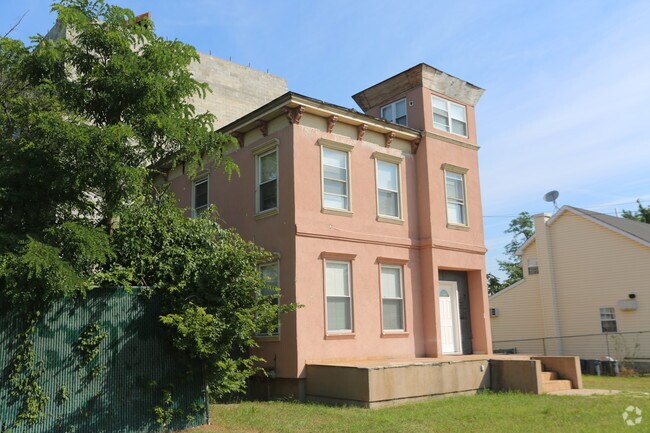
Property Record
175 Ellis St, Staten Island, NY 10307

Property Detail
175 Ellis St
07996-0031
Richmond
Officebuilding
New York
M1-1
31
AE The base floodplain where base flood elevations are provided. AE Zones are now used on new format FIRMs instead of A1-A30 Zones.
3.51 AC
2025
Staten Island
2026
Long Island (New York)
024800
New York-Jersey City-White Plains, NY-NJ
10,370 SF
NEARBY LISTINGS FOR SALE OR LEASE
DEMOGRAPHICS near 175 Ellis St
1 mile
3 mile
5 mile
2025 Total Population
20,564
109,364
284,028
2030 Population
20,953
110,137
290,057
Pop Growth 2025-2030
+ 1.89%
+ 0.71%
+ 2.12%
Average Age
39
40
41
2025 Total Households
7,007
37,178
100,462
HH Growth 2025-2030
+ 1.80%
+ 0.92%
+ 2.32%
Median Household Inc
$113,619
$85,458
$97,490
Avg Household Size
2.90
2.90
2.80
2025 Avg HH Vehicles
2.00
2.00
2.00
Median Home Value
$792,832
$633,253
$523,878
Median Year Built
1985
1977
1974
Nearby Places
Map Layers
Map Styles
 Street
 Aerial
Layers
 Traffic
 Biking
Places
Listings with unknown addresses are not visible on the map
- Restaurants
- Banks
- Shops
- Fitness
- Groceries
PUBLIC TRANSPORTATION
COMMUTER RAIL
Arthur Kill (Staten Island Railway - MTA New York City Transit)
Drive
Walk
Distance
Arthur Kill (Staten Island Railway - MTA New York City Transit)
0 min
5 min
0.2 mi
Tottenville (Staten Island Railway - New York MTA Subway (The Subway))
Drive
Walk
Distance
Tottenville (Staten Island Railway - New York MTA Subway (The Subway))
3 min
7 min
0.4 mi
AIRPORT
Newark Liberty International
Drive
Walk
Distance
Newark Liberty International
33 min
20.0 mi
LaGuardia
Drive
Walk
Distance
LaGuardia
57 min
33.6 mi
John F Kennedy International
Drive
Walk
Distance
John F Kennedy International
56 min
36.3 mi
Freight Ports
New York Container Terminal
Drive
Walk
Distance
New York Container Terminal
18 min
10.7 mi
SALE & LEASE HISTORY
LISTING DATE
SALE/LEASE

Apr 03, 2025
For Sale
Nearby Properties
Address
Land Use
TOTAL SIZE
Lot Size
Zoning
Address
Land Use
TOTAL SIZE
Lot Size
Zoning
37.32 AC
S-3B
Address
Land Use
TOTAL SIZE
Lot Size
Zoning
Address
Land Use
TOTAL SIZE
Lot Size
Zoning
53.04 AC
S-1F
Address
Land Use
TOTAL SIZE
Lot Size
Zoning
11.63 AC
S-3D
Address
Land Use
TOTAL SIZE
Lot Size
Zoning
411,000 SF
18.54 AC
R3X
Address
Land Use
TOTAL SIZE
Lot Size
Zoning
10.69 AC
R-MM
Address
Land Use
TOTAL SIZE
Lot Size
Zoning
15.15 AC
RMMF
Address
Land Use
TOTAL SIZE
Lot Size
Zoning
71.66 AC
M-3
Address
Land Use
TOTAL SIZE
Lot Size
Zoning
2.51 AC
H
Address
Land Use
TOTAL SIZE
Lot Size
Zoning
28.90 AC
S-3B
Address
Land Use
TOTAL SIZE
Lot Size
Zoning
52.97 AC
M-3
Address
Land Use
TOTAL SIZE
Lot Size
Zoning
220,240 SF
5.77 AC
R3X
Address
Land Use
TOTAL SIZE
Lot Size
Zoning
64.66 AC
S-3A
Address
Land Use
TOTAL SIZE
Lot Size
Zoning
38.58 AC
PARK
Address
Land Use
TOTAL SIZE
Lot Size
Zoning
6.79 AC
R-50
Address
Land Use
TOTAL SIZE
Lot Size
Zoning
7.23 AC
S-2A
Address
Land Use
TOTAL SIZE
Lot Size
Zoning
6,822 SF
29.22 AC
S-2C
Address
Land Use
TOTAL SIZE
Lot Size
Zoning
39.14 AC
M-3
Address
Land Use
TOTAL SIZE
Lot Size
Zoning
276 SF
6.59 AC
S-2A
Address
Land Use
TOTAL SIZE
Lot Size
Zoning
15,000 SF
16.63 AC
M1-1
Address
Land Use
TOTAL SIZE
Lot Size
Zoning
23.01 AC
S-1F
Address
Land Use
TOTAL SIZE
Lot Size
Zoning
35.05 AC
M-3
Address
Land Use
TOTAL SIZE
Lot Size
Zoning
30.50 AC
Address
Land Use
TOTAL SIZE
Lot Size
Zoning
135,000 SF
4.54 AC
R3X
Address
Land Use
TOTAL SIZE
Lot Size
Zoning
64.66 AC
S-3A
Address
Land Use
TOTAL SIZE
Lot Size
Zoning
9.72 AC
M-1
Address
Land Use
TOTAL SIZE
Lot Size
Zoning
60.44 AC
S-3A
Address
Land Use
TOTAL SIZE
Lot Size
Zoning
30,444 SF
11.60 AC
R-MM
Address
Land Use
TOTAL SIZE
Lot Size
Zoning
109,000 SF
3.38 AC
R3X
Address
Land Use
TOTAL SIZE
Lot Size
Zoning
21.50 AC
S-3A
The World's #1 Commercial Real Estate Marketplace
Connect with us
© 2026 CoStar Group
The information above has been obtained from sources believed reliable. While we do not doubt its accuracy we have not verified it and make no guarantee, warranty or representation about it. It is your responsibility to independently confirm its accuracy and completeness. Any projections, opinions, assumptions, or estimates used are for example only and do not represent the current or future performance of the property. The value of this transaction to you depends on tax and other factors which should be evaluated by your tax, financial, and legal advisors. You and your advisors should conduct a careful, independent investigation of the property to determine to your satisfaction the suitability of the property for your needs.