Property Record
175 Foster Dr, Mcdonough, GA 30253

NEARBY LISTINGS FOR SALE OR LEASE
Property Detail
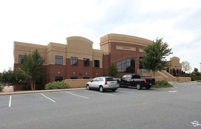
175 Foster Dr
Atlanta-Sandy Springs-Roswell, GA
Pinecrest Baptist Church
0053-01-005-000
LD: 6LL: 82+
Religious
Henry
X
Georgia
13151C0152D
82
2025
27.34 AC
2025
South Clayton/Henry Cnty
070310
Atlanta
93,036 SF
DEMOGRAPHICS near 175 Foster Dr
1 mile
3 mile
5 mile
2024 Total Population
3,828
38,653
98,815
2029 Population
4,214
42,332
108,013
Pop Growth 2024-2029
+ 10.08%
+ 9.52%
+ 9.31%
Average Age
36
37
38
2024 Total Households
1,263
13,255
35,334
HH Growth 2024-2029
+ 10.13%
+ 9.61%
+ 9.39%
Median Household Inc
$87,682
$82,702
$75,194
Avg Household Size
2.90
2.90
2.70
2024 Avg HH Vehicles
3.00
2.00
2.00
Median Home Value
$242,409
$252,716
$241,719
Median Year Built
2003
2000
2000
Nearby Places
Map Layers
Map Styles
 Street
 Aerial
Transit
 Traffic
 Biking
Places
Listings with unknown addresses are not visible on the map
- Restaurants
- Banks
- Shops
- Fitness
- Groceries
PUBLIC TRANSPORTATION
AIRPORT
Hartsfield - Jackson Atlanta International
Drive
Walk
Distance
Hartsfield - Jackson Atlanta International
30 min
21.0 mi
Freight Ports
Georgia Ports - Savannah
Drive
Walk
Distance
Georgia Ports - Savannah
251 min
223.7 mi
Nearby Properties
Address
Land Use
TOTAL SIZE
Lot Size
Zoning
Address
Land Use
TOTAL SIZE
Lot Size
Zoning
16,649 SF
29.98 AC
RM
Address
Land Use
TOTAL SIZE
Lot Size
Zoning
67,298 SF
30.88 AC
RM
Address
Land Use
TOTAL SIZE
Lot Size
Zoning
27,850 SF
15.19 AC
Address
Land Use
TOTAL SIZE
Lot Size
Zoning
106,512 SF
10.76 AC
Address
Land Use
TOTAL SIZE
Lot Size
Zoning
29,768 SF
50.81 AC
RM
Address
Land Use
TOTAL SIZE
Lot Size
Zoning
39,169 SF
7.54 AC
RM
Address
Land Use
TOTAL SIZE
Lot Size
Zoning
59,445 SF
20.17 AC
PD
Address
Land Use
TOTAL SIZE
Lot Size
Zoning
30,396 SF
21.12 AC
Address
Land Use
TOTAL SIZE
Lot Size
Zoning
11,256 SF
34.51 AC
RM
Address
Land Use
TOTAL SIZE
Lot Size
Zoning
29,934 SF
18.18 AC
C2
Address
Land Use
TOTAL SIZE
Lot Size
Zoning
5,485 SF
27.03 AC
RM
Address
Land Use
TOTAL SIZE
Lot Size
Zoning
23,400 SF
29 AC
RM
Address
Land Use
TOTAL SIZE
Lot Size
Zoning
498,160 SF
44.14 AC
M1
Address
Land Use
TOTAL SIZE
Lot Size
Zoning
3,114 SF
15.44 AC
RM
Address
Land Use
TOTAL SIZE
Lot Size
Zoning
76,608 SF
26.99 AC
R2
Address
Land Use
TOTAL SIZE
Lot Size
Zoning
127,960 SF
93.84 AC
RA
Address
Land Use
TOTAL SIZE
Lot Size
Zoning
72,898 SF
24 AC
C3
Address
Land Use
TOTAL SIZE
Lot Size
Zoning
151,123 SF
26.05 AC
C3
Address
Land Use
TOTAL SIZE
Lot Size
Zoning
425,476 SF
58.85 AC
PD
Address
Land Use
TOTAL SIZE
Lot Size
Zoning
74,395 SF
49.35 AC
PD
Address
Land Use
TOTAL SIZE
Lot Size
Zoning
111,398 SF
15.54 AC
C2
Address
Land Use
TOTAL SIZE
Lot Size
Zoning
653,368 SF
17.84 AC
Address
Land Use
TOTAL SIZE
Lot Size
Zoning
68,500 SF
140.42 AC
R2
Address
Land Use
TOTAL SIZE
Lot Size
Zoning
2,784 SF
8.93 AC
RM
Address
Land Use
TOTAL SIZE
Lot Size
Zoning
175,828 SF
19.77 AC
C3
Address
Land Use
TOTAL SIZE
Lot Size
Zoning
215,523 SF
22.18 AC
C2
Address
Land Use
TOTAL SIZE
Lot Size
Zoning
675,312 SF
26.60 AC
M1
Address
Land Use
TOTAL SIZE
Lot Size
Zoning
62,142 SF
4.36 AC
C1
Address
Land Use
TOTAL SIZE
Lot Size
Zoning
70.85 AC
C2
Address
Land Use
TOTAL SIZE
Lot Size
Zoning
54,056 SF
10.40 AC
OI
The World's #1 Commercial Real Estate Marketplace
Connect with us
© 2026 CoStar Group
The information above has been obtained from sources believed reliable. While we do not doubt its accuracy we have not verified it and make no guarantee, warranty or representation about it. It is your responsibility to independently confirm its accuracy and completeness. Any projections, opinions, assumptions, or estimates used are for example only and do not represent the current or future performance of the property. The value of this transaction to you depends on tax and other factors which should be evaluated by your tax, financial, and legal advisors. You and your advisors should conduct a careful, independent investigation of the property to determine to your satisfaction the suitability of the property for your needs.