Property Record
175 Hawley St, Marquette, MI 49855
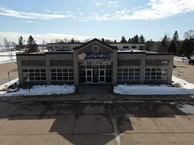
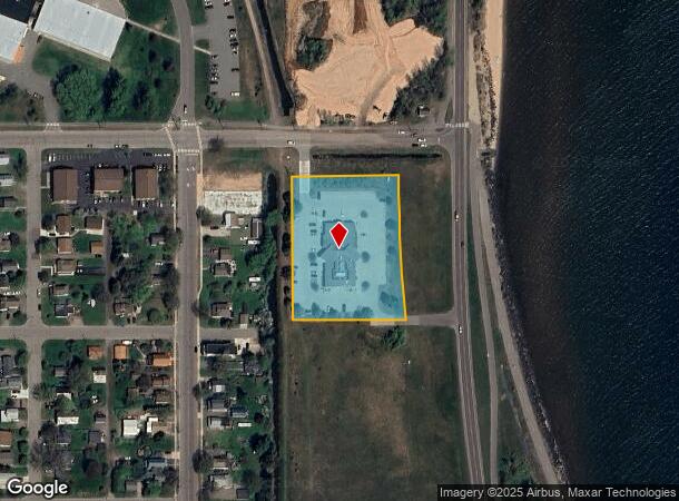
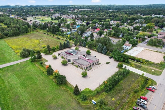
This Property Is For Sale
Current Lease Availabilities
NEARBY LISTINGS FOR SALE OR LEASE
Property Detail
175 Hawley St
52-52-005-109-91
SEC 11 T48N R25W (92,858.67 SF / 2.1317 A M/L) PRT OF THE NW 1/4 OF THE SE 1/4 OF SD SEC 11 COMM AT THE S 1/4 COR OF SD SEC 1
Commercialnec
Marquette
X
Michigan
26103C0485E
2.13 AC
2025
Upper Peninsula
2025
Other Market Areas
000600
Marquette, MI
11,854 SF
DEMOGRAPHICS near 175 Hawley St
1 Mile
3 Mile
5 Mile
2024 Total Population
3,043
20,802
24,281
2029 Population
3,054
20,983
24,555
Pop Growth 2024-2029
+ 0.36%
+ 0.87%
+ 1.13%
Average Age
30
39
39
2024 Total Households
1,021
8,812
10,008
HH Growth 2024-2029
+ 0.10%
+ 0.90%
+ 1.14%
Median Household Inc
$34,294
$47,637
$49,098
Avg Household Size
2.00
2.00
2.00
2024 Avg HH Vehicles
2.00
2.00
2.00
Median Home Value
$164,479
$219,123
$231,609
Median Year Built
1971
1969
1971
Nearby Places
Map Layers
Map Styles
 Street
 Aerial
- Restaurants
- Banks
- Shops
- Fitness
- Groceries
PUBLIC TRANSPORTATION
AIRPORT
Marquette/Sawyer Regional
DRIVE
WALK
Distance
Marquette/Sawyer Regional
34 min
18.0 mi
Nearby Properties
Address
Land Use
TOTAL SIZE
Lot Size
Zoning
Address
Land Use
TOTAL SIZE
Lot Size
Zoning
605,039 SF
39.11 AC
PUD
Address
Land Use
TOTAL SIZE
Lot Size
Zoning
254,287 SF
11.83 AC
M-U
Address
Land Use
TOTAL SIZE
Lot Size
Zoning
276,832 SF
21.36 AC
MFR
Address
Land Use
TOTAL SIZE
Lot Size
Zoning
104,333 SF
8.14 AC
RC
Address
Land Use
TOTAL SIZE
Lot Size
Zoning
106,380 SF
1.41 AC
PUD
Address
Land Use
TOTAL SIZE
Lot Size
Zoning
184,024 SF
7.52 AC
MFR
Address
Land Use
TOTAL SIZE
Lot Size
Zoning
79,558 SF
17.85 AC
RC
Address
Land Use
TOTAL SIZE
Lot Size
Zoning
105,283 SF
6.40 AC
IM
Address
Land Use
TOTAL SIZE
Lot Size
Zoning
58,524 SF
4.02 AC
M-U
Address
Land Use
TOTAL SIZE
Lot Size
Zoning
23,286 SF
0.76 AC
PUD
Address
Land Use
TOTAL SIZE
Lot Size
Zoning
36,720 SF
I
Address
Land Use
TOTAL SIZE
Lot Size
Zoning
78,717 SF
19.14 AC
RC
Address
Land Use
TOTAL SIZE
Lot Size
Zoning
49,463 SF
5.16 AC
PUD
Address
Land Use
TOTAL SIZE
Lot Size
Zoning
45,775 SF
1.49 AC
F 5
Address
Land Use
TOTAL SIZE
Lot Size
Zoning
48,579 SF
0.81 AC
PUD
Address
Land Use
TOTAL SIZE
Lot Size
Zoning
38,763 SF
I
Address
Land Use
TOTAL SIZE
Lot Size
Zoning
55,204 SF
1.13 AC
GC
Address
Land Use
TOTAL SIZE
Lot Size
Zoning
7.89 AC
DD
Address
Land Use
TOTAL SIZE
Lot Size
Zoning
126,697 SF
8.62 AC
GC
Address
Land Use
TOTAL SIZE
Lot Size
Zoning
42,108 SF
0.95 AC
CBD
Address
Land Use
TOTAL SIZE
Lot Size
Zoning
37,112 SF
3.05 AC
GC
Address
Land Use
TOTAL SIZE
Lot Size
Zoning
95,476 SF
7.29 AC
GB
Address
Land Use
TOTAL SIZE
Lot Size
Zoning
79,508 SF
6.69 AC
MFR
Address
Land Use
TOTAL SIZE
Lot Size
Zoning
45,426 SF
1.86 AC
GB
Address
Land Use
TOTAL SIZE
Lot Size
Zoning
46,037 SF
4.02 AC
MFR
Address
Land Use
TOTAL SIZE
Lot Size
Zoning
75,836 SF
2.24 AC
CBD
Address
Land Use
TOTAL SIZE
Lot Size
Zoning
60,034 SF
0.92 AC
G 5
Address
Land Use
TOTAL SIZE
Lot Size
Zoning
22,188 SF
0.79 AC
G 5
Address
Land Use
TOTAL SIZE
Lot Size
Zoning
18,573 SF
2.75 AC
M-U
Address
Land Use
TOTAL SIZE
Lot Size
Zoning
14,612 SF
0.58 AC
G 5
The World's #1 Commercial Real Estate Marketplace
Connect with us
© 2026 CoStar Group
The information above has been obtained from sources believed reliable. While we do not doubt its accuracy we have not verified it and make no guarantee, warranty or representation about it. It is your responsibility to independently confirm its accuracy and completeness. Any projections, opinions, assumptions, or estimates used are for example only and do not represent the current or future performance of the property. The value of this transaction to you depends on tax and other factors which should be evaluated by your tax, financial, and legal advisors. You and your advisors should conduct a careful, independent investigation of the property to determine to your satisfaction the suitability of the property for your needs.