Property Record
175 Kings Hwy, Punta Gorda, FL 33983
This Property Is For Sale
NEARBY LISTINGS FOR SALE OR LEASE
Property Detail
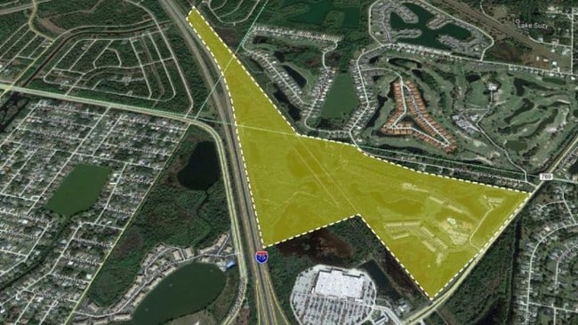
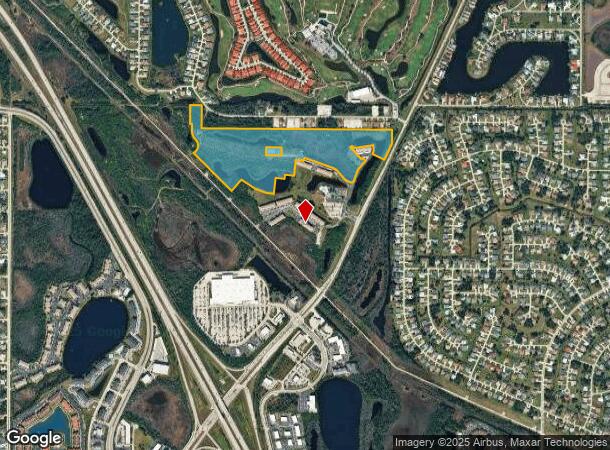
175 Kings Hwy
Punta Gorda, FL
First Replat In Pembroke Subdivision
402306227015
ZZZ 064023 P1-9-2 37.69AC M/L N 77FT THNC W 266FT THNC NW 42FT THNC SW 33FT THNC SE 95FT TO A CRV RIGHT HAVING A RAD OF 25FT BEARING SE FOR 15FT THNC SE 112 THNC NE 23FT SE 56FT THNC SW 128FT TO A CRV LEFT HAVING A RAD OF 192FT BEARING SW FOR 69FT T
Commercialnec
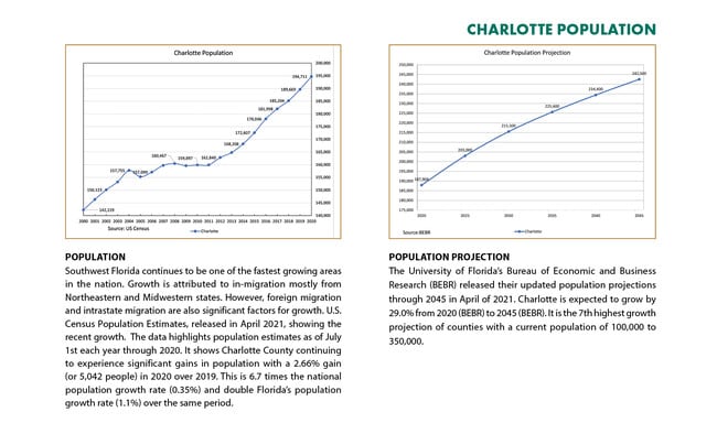
Charlotte
A
Florida
12015C0068G
3
2024
37.68 AC
2025
Charlotte County
020104
Southwest Florida
DEMOGRAPHICS near 175 Kings Hwy
1 Mile
3 Mile
5 Mile
2024 Total Population
5,094
33,749
80,227
2029 Population
5,969
40,125
95,227
Pop Growth 2024-2029
+ 17.18%
+ 18.89%
+ 18.70%
Average Age
56
52
50
2024 Total Households
2,613
15,130
35,436
HH Growth 2024-2029
+ 17.76%
+ 19.28%
+ 19.10%
Median Household Inc
$58,678
$62,483
$56,296
Avg Household Size
1.90
2.20
2.20
2024 Avg HH Vehicles
2.00
2.00
2.00
Median Home Value
$233,205
$236,196
$222,361
Median Year Built
1998
1992
1987
Nearby Places
Map Layers
Map Styles
 Street
 Aerial
- Restaurants
- Banks
- Shops
- Fitness
- Groceries
PUBLIC TRANSPORTATION
AIRPORT
Punta Gorda
DRIVE
WALK
Distance
Punta Gorda
16 min
10.4 mi
Freight Ports
Port Manatee
DRIVE
WALK
Distance
Port Manatee
76 min
64.8 mi
Nearby Properties
Address
Land Use
TOTAL SIZE
Lot Size
Zoning
Address
Land Use
TOTAL SIZE
Lot Size
Zoning
202,009 SF
20.89 AC
PD
Address
Land Use
TOTAL SIZE
Lot Size
Zoning
204,731 SF
16.11 AC
PD
Address
Land Use
TOTAL SIZE
Lot Size
Zoning
229,973 SF
21.33 AC
PD
Address
Land Use
TOTAL SIZE
Lot Size
Zoning
249,777 SF
48 AC
RMF10
Address
Land Use
TOTAL SIZE
Lot Size
Zoning
217,784 SF
38.63 AC
PD
Address
Land Use
TOTAL SIZE
Lot Size
Zoning
139,109 SF
23.44 AC
CG
Address
Land Use
TOTAL SIZE
Lot Size
Zoning
73,222 SF
5.14 AC
PD
Address
Land Use
TOTAL SIZE
Lot Size
Zoning
50,970 SF
9.74 AC
RSF3.5
Address
Land Use
TOTAL SIZE
Lot Size
Zoning
41,148 SF
155.85 AC
RSF-3
Address
Land Use
TOTAL SIZE
Lot Size
Zoning
83,180 SF
9.31 AC
PD
Address
Land Use
TOTAL SIZE
Lot Size
Zoning
95,547 SF
14.06 AC
PD
Address
Land Use
TOTAL SIZE
Lot Size
Zoning
35,951 SF
24.23 AC
PD
Address
Land Use
TOTAL SIZE
Lot Size
Zoning
27,082 SF
2.05 AC
PD
Address
Land Use
TOTAL SIZE
Lot Size
Zoning
84,500 SF
5.59 AC
CG
Address
Land Use
TOTAL SIZE
Lot Size
Zoning
86,773 SF
5.07 AC
IG
Address
Land Use
TOTAL SIZE
Lot Size
Zoning
23,798 SF
1.71 AC
PD
Address
Land Use
TOTAL SIZE
Lot Size
Zoning
98,552 SF
11.42 AC
CG
Address
Land Use
TOTAL SIZE
Lot Size
Zoning
82.27 AC
PD
Address
Land Use
TOTAL SIZE
Lot Size
Zoning
21.61 AC
PD
Address
Land Use
TOTAL SIZE
Lot Size
Zoning
81,226 SF
11.40 AC
OMI
Address
Land Use
TOTAL SIZE
Lot Size
Zoning
12,977 SF
2.29 AC
PD
Address
Land Use
TOTAL SIZE
Lot Size
Zoning
13,642 SF
2.55 AC
PD
Address
Land Use
TOTAL SIZE
Lot Size
Zoning
36,798 SF
19.40 AC
RSF3.5
Address
Land Use
TOTAL SIZE
Lot Size
Zoning
34,983 SF
18.79 AC
RE1
Address
Land Use
TOTAL SIZE
Lot Size
Zoning
11,773 SF
1.55 AC
PD
Address
Land Use
TOTAL SIZE
Lot Size
Zoning
7.81 AC
PD
Address
Land Use
TOTAL SIZE
Lot Size
Zoning
30,928 SF
41.30 AC
PKR
Address
Land Use
TOTAL SIZE
Lot Size
Zoning
73,260 SF
7.68 AC
PD
Address
Land Use
TOTAL SIZE
Lot Size
Zoning
74,434 SF
4.42 AC
CG
Address
Land Use
TOTAL SIZE
Lot Size
Zoning
23,566 SF
20.33 AC
RMF10
The World's #1 Commercial Real Estate Marketplace
Connect with us
© 2025 CoStar Group
The information above has been obtained from sources believed reliable. While we do not doubt its accuracy we have not verified it and make no guarantee, warranty or representation about it. It is your responsibility to independently confirm its accuracy and completeness. Any projections, opinions, assumptions, or estimates used are for example only and do not represent the current or future performance of the property. The value of this transaction to you depends on tax and other factors which should be evaluated by your tax, financial, and legal advisors. You and your advisors should conduct a careful, independent investigation of the property to determine to your satisfaction the suitability of the property for your needs.