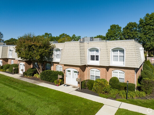
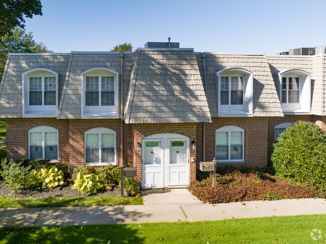
Property Record
175 Main Ave, Wheatley Heights, NY 11798
NEARBY LISTINGS FOR SALE OR LEASE
Property Detail
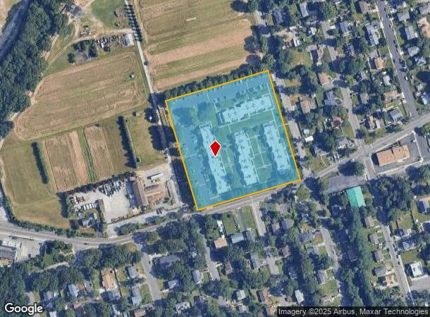
175 Main Ave
Nassau County-Suffolk County, NY
Map #1 Wyandanch Springs Improvements Co
0100-013-00-02-00-018-004
FM 1-62 BLK 57 &58 LOTS PTS 1-4 5-13&36-44 ALL INC &PT STREET
Commercialcondominium
Suffolk
X
New York
36103C0640H
18
2024
4.97 AC
2024
Wheatley Heights
158107
Long Island (New York)
DEMOGRAPHICS near 175 Main Ave
1 Mile
3 Mile
5 Mile
2024 Total Population
13,057
84,582
246,696
2029 Population
12,769
82,723
241,637
Pop Growth 2024-2029
(2.21%)
(2.20%)
(2.05%)
Average Age
37
40
41
2024 Total Households
3,404
26,045
80,296
HH Growth 2024-2029
(2.29%)
(2.43%)
(2.23%)
Median Household Inc
$103,779
$118,913
$120,303
Avg Household Size
3.50
3.10
2.90
2024 Avg HH Vehicles
2.00
2.00
2.00
Median Home Value
$453,542
$476,751
$485,501
Median Year Built
1973
1965
1963
Nearby Places
- Restaurants
- Banks
- Shops
- Fitness
- Groceries
PUBLIC TRANSPORTATION
COMMUTER RAIL
Wyandanch Station (Ronkonkoma Branch - Long Island Rail Road)
DRIVE
WALK
Distance
Wyandanch Station (Ronkonkoma Branch - Long Island Rail Road)
3 min
20 min
1.0 mi
Pinelawn Station (Ronkonkoma Branch - Long Island Rail Road)
DRIVE
WALK
Distance
Pinelawn Station (Ronkonkoma Branch - Long Island Rail Road)
6 min
2.7 mi
AIRPORT
Long Island MacArthur
DRIVE
WALK
Distance
Long Island MacArthur
29 min
17.6 mi
John F Kennedy International
DRIVE
WALK
Distance
John F Kennedy International
42 min
29.2 mi
LaGuardia
DRIVE
WALK
Distance
LaGuardia
48 min
31.0 mi
Freight Ports
NY - Red Hook Container Terminal
DRIVE
WALK
Distance
NY - Red Hook Container Terminal
60 min
39.1 mi
Nearby Properties
Address
Land Use
TOTAL SIZE
Lot Size
Zoning
Address
Land Use
TOTAL SIZE
Lot Size
Zoning
756 SF
0.36 AC
B1
Address
Land Use
TOTAL SIZE
Lot Size
Zoning
37 AC
I2
Address
Land Use
TOTAL SIZE
Lot Size
Zoning
3.31 AC
R40
Address
Land Use
TOTAL SIZE
Lot Size
Zoning
336,442 SF
43.50 AC
G
Address
Land Use
TOTAL SIZE
Lot Size
Zoning
2,388 SF
0.36 AC
B1
Address
Land Use
TOTAL SIZE
Lot Size
Zoning
400 AC
A
Address
Land Use
TOTAL SIZE
Lot Size
Zoning
37.20 AC
I2
Address
Land Use
TOTAL SIZE
Lot Size
Zoning
24.75 AC
R40
Address
Land Use
TOTAL SIZE
Lot Size
Zoning
183.15 AC
Address
Land Use
TOTAL SIZE
Lot Size
Zoning
1,680 SF
0.15 AC
B1
Address
Land Use
TOTAL SIZE
Lot Size
Zoning
5.95 AC
C
Address
Land Use
TOTAL SIZE
Lot Size
Zoning
0.55 AC
VILLA
Address
Land Use
TOTAL SIZE
Lot Size
Zoning
16.90 AC
EA
Address
Land Use
TOTAL SIZE
Lot Size
Zoning
12 AC
I1
Address
Land Use
TOTAL SIZE
Lot Size
Zoning
22.20 AC
I1
Address
Land Use
TOTAL SIZE
Lot Size
Zoning
114.70 AC
A
Address
Land Use
TOTAL SIZE
Lot Size
Zoning
292.40 AC
A
Address
Land Use
TOTAL SIZE
Lot Size
Zoning
0.26 AC
R20
Address
Land Use
TOTAL SIZE
Lot Size
Zoning
32.60 AC
I1
Address
Land Use
TOTAL SIZE
Lot Size
Zoning
52.20 AC
R40
Address
Land Use
TOTAL SIZE
Lot Size
Zoning
16.81 AC
Address
Land Use
TOTAL SIZE
Lot Size
Zoning
248.60 AC
A
Address
Land Use
TOTAL SIZE
Lot Size
Zoning
16 AC
I1
Address
Land Use
TOTAL SIZE
Lot Size
Zoning
23.66 AC
I1
Address
Land Use
TOTAL SIZE
Lot Size
Zoning
21.50 AC
I1
Address
Land Use
TOTAL SIZE
Lot Size
Zoning
33 AC
R40
Address
Land Use
TOTAL SIZE
Lot Size
Zoning
260,092 SF
7.07 AC
GA
Address
Land Use
TOTAL SIZE
Lot Size
Zoning
7.50 AC
C2
Address
Land Use
TOTAL SIZE
Lot Size
Zoning
15.20 AC
Address
Land Use
TOTAL SIZE
Lot Size
Zoning
14.50 AC
C10
The World's #1 Commercial Real Estate Marketplace
Connect with us
© 2025 CoStar Group
The information above has been obtained from sources believed reliable. While we do not doubt its accuracy we have not verified it and make no guarantee, warranty or representation about it. It is your responsibility to independently confirm its accuracy and completeness. Any projections, opinions, assumptions, or estimates used are for example only and do not represent the current or future performance of the property. The value of this transaction to you depends on tax and other factors which should be evaluated by your tax, financial, and legal advisors. You and your advisors should conduct a careful, independent investigation of the property to determine to your satisfaction the suitability of the property for your needs.