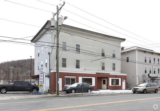
Property Record
175 Main St, Winsted, CT 06098

Property Detail
175 Main St
WINC-000111-000070-000018
Nw Hills
Commercialbuilding
Connecticut
CB-2
18
2025
0.13 AC
2025
Litchfield County
320102
Hartford
4,860 SF
Torrington, CT
NEARBY LISTINGS FOR SALE OR LEASE
-
-
View all Winsted listings for sale on LoopNet.com
DEMOGRAPHICS near 175 Main St
1 mile
3 mile
5 mile
2025 Total Population
6,104
10,863
19,250
2030 Population
6,162
11,045
19,650
Pop Growth 2025-2030
+ 0.95%
+ 1.68%
+ 2.08%
Average Age
44
44
45
2025 Total Households
2,794
4,900
8,263
HH Growth 2025-2030
+ 0.93%
+ 1.69%
+ 2.12%
Median Household Inc
$66,907
$71,137
$86,587
Avg Household Size
2.10
2.20
2.30
2025 Avg HH Vehicles
2.00
2.00
2.00
Median Home Value
$241,452
$270,181
$293,182
Median Year Built
1949
1954
1967
Nearby Places
Map Layers
Map Styles
 Street
 Aerial
Transit
 Traffic
 Biking
Places
Listings with unknown addresses are not visible on the map
- Restaurants
- Banks
- Shops
- Fitness
- Groceries
PUBLIC TRANSPORTATION
AIRPORT
Bradley International
Drive
Walk
Distance
Bradley International
51 min
26.5 mi
Freight Ports
Port of New Haven
Drive
Walk
Distance
Port of New Haven
74 min
53.6 mi
SALE & LEASE HISTORY
LISTING DATE
SALE/LEASE

May 01, 2018
For Lease
Jul 28, 2024
For Sale
Feb 25, 2022
For Lease
Apr 05, 2021
For Lease
Nearby Properties
Address
Land Use
TOTAL SIZE
Lot Size
Zoning
Address
Land Use
TOTAL SIZE
Lot Size
Zoning
224,385 SF
26.20 AC
RU-2
Address
Land Use
TOTAL SIZE
Lot Size
Zoning
13.79 AC
CX
Address
Land Use
TOTAL SIZE
Lot Size
Zoning
95,810 SF
5.60 AC
R-3
Address
Land Use
TOTAL SIZE
Lot Size
Zoning
76,339 SF
124.53 AC
R-1
Address
Land Use
TOTAL SIZE
Lot Size
Zoning
20,544 SF
2.42 AC
CB-2
Address
Land Use
TOTAL SIZE
Lot Size
Zoning
56,852 SF
3 AC
R-3
Address
Land Use
TOTAL SIZE
Lot Size
Zoning
54,920 SF
11.87 AC
R-3
Address
Land Use
TOTAL SIZE
Lot Size
Zoning
24,618 SF
3.63 AC
CB-2
Address
Land Use
TOTAL SIZE
Lot Size
Zoning
5.11 AC
R-3
Address
Land Use
TOTAL SIZE
Lot Size
Zoning
2.32 AC
CB-2
Address
Land Use
TOTAL SIZE
Lot Size
Zoning
9,976 SF
13.10 AC
RU-2
Address
Land Use
TOTAL SIZE
Lot Size
Zoning
53,252 SF
32.19 AC
RU-1
Address
Land Use
TOTAL SIZE
Lot Size
Zoning
32,000 SF
6.33 AC
IB-1
Address
Land Use
TOTAL SIZE
Lot Size
Zoning
7,888 SF
8.72 AC
RU-2
Address
Land Use
TOTAL SIZE
Lot Size
Zoning
33,268 SF
5.27 AC
RA-2
Address
Land Use
TOTAL SIZE
Lot Size
Zoning
2.21 AC
IB-1
Address
Land Use
TOTAL SIZE
Lot Size
Zoning
50,068 SF
1.97 AC
R-3
Address
Land Use
TOTAL SIZE
Lot Size
Zoning
24,000 SF
0.44 AC
CB-2
Address
Land Use
TOTAL SIZE
Lot Size
Zoning
120,472 SF
28.82 AC
IA-1
Address
Land Use
TOTAL SIZE
Lot Size
Zoning
42,850 SF
0.36 AC
CB-3
Address
Land Use
TOTAL SIZE
Lot Size
Zoning
45 AC
RU-1
Address
Land Use
TOTAL SIZE
Lot Size
Zoning
3.17 AC
IB-3
Address
Land Use
TOTAL SIZE
Lot Size
Zoning
12,960 SF
244.96 AC
RU-3
Address
Land Use
TOTAL SIZE
Lot Size
Zoning
10,125 SF
1.34 AC
CB-2
Address
Land Use
TOTAL SIZE
Lot Size
Zoning
7,225 SF
4.90 AC
B-2
Address
Land Use
TOTAL SIZE
Lot Size
Zoning
28,226 SF
0.96 AC
CX
Address
Land Use
TOTAL SIZE
Lot Size
Zoning
38,896 SF
0.96 AC
IB-1
Address
Land Use
TOTAL SIZE
Lot Size
Zoning
88,168 SF
14.59 AC
IA-1
Address
Land Use
TOTAL SIZE
Lot Size
Zoning
29,968 SF
3.72 AC
R-4
Address
Land Use
TOTAL SIZE
Lot Size
Zoning
16.78 AC
I-2
The World's #1 Commercial Real Estate Marketplace
Connect with us
© 2026 CoStar Group
The information above has been obtained from sources believed reliable. While we do not doubt its accuracy we have not verified it and make no guarantee, warranty or representation about it. It is your responsibility to independently confirm its accuracy and completeness. Any projections, opinions, assumptions, or estimates used are for example only and do not represent the current or future performance of the property. The value of this transaction to you depends on tax and other factors which should be evaluated by your tax, financial, and legal advisors. You and your advisors should conduct a careful, independent investigation of the property to determine to your satisfaction the suitability of the property for your needs.