Property Record
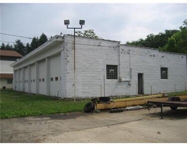
175 Memorial Dr, Perryopolis, PA 15473


Property Detail
175 Memorial Dr
27-14-0052
0.739 AC COML GAR
Autorepair
FAYETTE
B and X Area of moderate flood hazard, usually the area between the limits of the 100-year and 500-year floods.
Pennsylvania
2025
0.73 AC
2026
Fayette County
260200
Pittsburgh
4,000 SF
Pittsburgh, PA
NEARBY LISTINGS FOR SALE OR LEASE
-
-
View all Perryopolis listings for sale on LoopNet.com
DEMOGRAPHICS near 175 Memorial Dr
1 mile
3 mile
5 mile
2025 Total Population
724
4,191
12,617
2030 Population
698
4,003
12,479
Pop Growth 2025-2030
(3.59%)
(4.49%)
(1.09%)
Average Age
47
46
46
2025 Total Households
316
1,786
5,332
HH Growth 2025-2030
(3.80%)
(4.70%)
(1.35%)
Median Household Inc
$58,333
$58,134
$58,908
Avg Household Size
2.20
2.30
2.30
2025 Avg HH Vehicles
2.00
2.00
2.00
Median Home Value
$187,704
$196,125
$186,180
Median Year Built
1961
1958
1962
Nearby Places
Map Layers
Map Styles
 Street
 Aerial
Layers
 Traffic
 Biking
Places
Listings with unknown addresses are not visible on the map
- Restaurants
- Banks
- Shops
- Fitness
- Groceries
PUBLIC TRANSPORTATION
AIRPORT
Arnold Palmer Regional
Drive
Walk
Distance
Arnold Palmer Regional
53 min
34.0 mi
Pittsburgh International
Drive
Walk
Distance
Pittsburgh International
80 min
47.9 mi
Nearby Properties
Address
Land Use
TOTAL SIZE
Lot Size
Zoning
Address
Land Use
TOTAL SIZE
Lot Size
Zoning
110,746 SF
4.84 AC
Address
Land Use
TOTAL SIZE
Lot Size
Zoning
16,612 SF
13.34 AC
Address
Land Use
TOTAL SIZE
Lot Size
Zoning
7,962 SF
2.11 AC
Address
Land Use
TOTAL SIZE
Lot Size
Zoning
4,608 SF
4 AC
Address
Land Use
TOTAL SIZE
Lot Size
Zoning
24,500 SF
8.62 AC
Address
Land Use
TOTAL SIZE
Lot Size
Zoning
12,000 SF
25.77 AC
Address
Land Use
TOTAL SIZE
Lot Size
Zoning
4,800 SF
12.14 AC
Address
Land Use
TOTAL SIZE
Lot Size
Zoning
14,110 SF
8.29 AC
Address
Land Use
TOTAL SIZE
Lot Size
Zoning
5,094 SF
2.31 AC
Address
Land Use
TOTAL SIZE
Lot Size
Zoning
12,622 SF
1.89 AC
Address
Land Use
TOTAL SIZE
Lot Size
Zoning
19,325 SF
1.55 AC
Address
Land Use
TOTAL SIZE
Lot Size
Zoning
12,236 SF
9.45 AC
Address
Land Use
TOTAL SIZE
Lot Size
Zoning
12,400 SF
8.37 AC
Address
Land Use
TOTAL SIZE
Lot Size
Zoning
6,656 SF
0.98 AC
Address
Land Use
TOTAL SIZE
Lot Size
Zoning
8,843 SF
0.78 AC
Address
Land Use
TOTAL SIZE
Lot Size
Zoning
20,800 SF
16.15 AC
Address
Land Use
TOTAL SIZE
Lot Size
Zoning
Address
Land Use
TOTAL SIZE
Lot Size
Zoning
Address
Land Use
TOTAL SIZE
Lot Size
Zoning
7,878 SF
1.13 AC
Address
Land Use
TOTAL SIZE
Lot Size
Zoning
13,773 SF
1.50 AC
Address
Land Use
TOTAL SIZE
Lot Size
Zoning
2,444 SF
2 AC
Address
Land Use
TOTAL SIZE
Lot Size
Zoning
14,400 SF
2 AC
Address
Land Use
TOTAL SIZE
Lot Size
Zoning
2,907 SF
0.89 AC
Address
Land Use
TOTAL SIZE
Lot Size
Zoning
600 SF
5 AC
Address
Land Use
TOTAL SIZE
Lot Size
Zoning
5,660 SF
0.61 AC
Address
Land Use
TOTAL SIZE
Lot Size
Zoning
4,000 SF
1.19 AC
Address
Land Use
TOTAL SIZE
Lot Size
Zoning
15,018 SF
0.49 AC
Address
Land Use
TOTAL SIZE
Lot Size
Zoning
3,840 SF
96.70 AC
Address
Land Use
TOTAL SIZE
Lot Size
Zoning
12,158 SF
0.13 AC
Address
Land Use
TOTAL SIZE
Lot Size
Zoning
15,852 SF
2.30 AC
The World's #1 Commercial Real Estate Marketplace
Connect with us
© 2026 CoStar Group
The information above has been obtained from sources believed reliable. While we do not doubt its accuracy we have not verified it and make no guarantee, warranty or representation about it. It is your responsibility to independently confirm its accuracy and completeness. Any projections, opinions, assumptions, or estimates used are for example only and do not represent the current or future performance of the property. The value of this transaction to you depends on tax and other factors which should be evaluated by your tax, financial, and legal advisors. You and your advisors should conduct a careful, independent investigation of the property to determine to your satisfaction the suitability of the property for your needs.