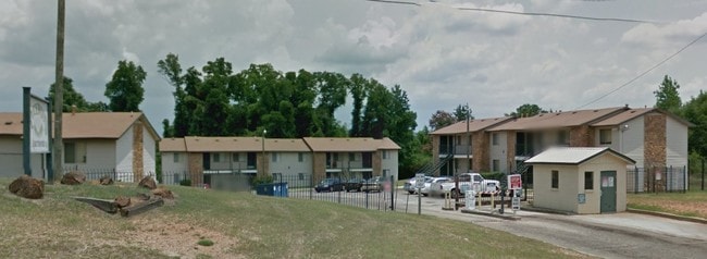
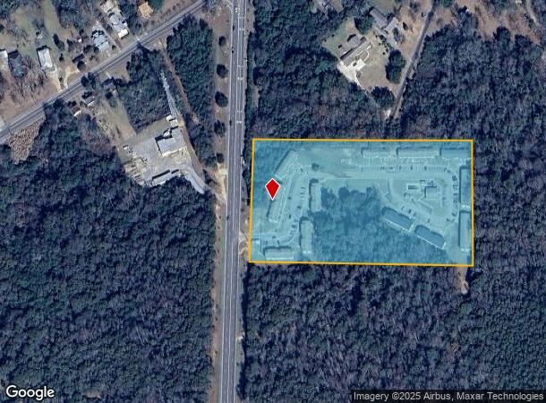
Property Record
175 N Highway 21 Byp, Monroeville, AL 36460
NEARBY LISTINGS FOR SALE OR LEASE
-
-
View all Monroeville listings for sale on LoopNet.com
Property Detail
175 N Highway 21 Byp
Realpropertynec
NORTH 462 OF S 715(S) OF NE14 SEC 36 LYING E OF HWY 21 BYPASS
X
Monroe
01099C0370C
Alabama
2025
9 AC
2024
Alabama South Area
076000
Other Market Areas
5,076 SF
21073610000600010
DEMOGRAPHICS near 175 N Highway 21 Byp
1 Mile
3 Mile
5 Mile
2024 Total Population
1,234
6,041
7,733
2029 Population
1,189
5,866
7,529
Pop Growth 2024-2029
(3.65%)
(2.90%)
(2.64%)
Average Age
38
41
42
2024 Total Households
505
2,556
3,273
HH Growth 2024-2029
(3.37%)
(2.58%)
(2.32%)
Median Household Inc
$27,348
$31,273
$31,800
Avg Household Size
2.30
2.30
2.30
2024 Avg HH Vehicles
1.00
2.00
2.00
Median Home Value
$131,579
$123,851
$121,755
Median Year Built
1981
1980
1980
Nearby Places
Map Layers
Map Styles
 Street
 Aerial
- Restaurants
- Banks
- Shops
- Fitness
- Groceries
Nearby Properties
Address
Land Use
TOTAL SIZE
Lot Size
Zoning
Address
Land Use
TOTAL SIZE
Lot Size
Zoning
52,740 SF
17 AC
Address
Land Use
TOTAL SIZE
Lot Size
Zoning
318,178 SF
3 AC
Address
Land Use
TOTAL SIZE
Lot Size
Zoning
225,156 SF
18 AC
Address
Land Use
TOTAL SIZE
Lot Size
Zoning
91,498 SF
34 AC
Address
Land Use
TOTAL SIZE
Lot Size
Zoning
24,022 SF
2.62 AC
Address
Land Use
TOTAL SIZE
Lot Size
Zoning
55,362 SF
0.78 AC
Address
Land Use
TOTAL SIZE
Lot Size
Zoning
14,131 SF
10 AC
Address
Land Use
TOTAL SIZE
Lot Size
Zoning
4,645 SF
79 AC
Address
Land Use
TOTAL SIZE
Lot Size
Zoning
38,564 SF
7 AC
Address
Land Use
TOTAL SIZE
Lot Size
Zoning
1,965 SF
9.90 AC
Address
Land Use
TOTAL SIZE
Lot Size
Zoning
19,840 SF
1.16 AC
Address
Land Use
TOTAL SIZE
Lot Size
Zoning
53,365 SF
8 AC
Address
Land Use
TOTAL SIZE
Lot Size
Zoning
51,779 SF
6 AC
Address
Land Use
TOTAL SIZE
Lot Size
Zoning
23,689 SF
7 AC
Address
Land Use
TOTAL SIZE
Lot Size
Zoning
9,220 SF
18 AC
Address
Land Use
TOTAL SIZE
Lot Size
Zoning
8,053 SF
3 AC
Address
Land Use
TOTAL SIZE
Lot Size
Zoning
6,692 SF
7 AC
Address
Land Use
TOTAL SIZE
Lot Size
Zoning
3,952 SF
3 AC
Address
Land Use
TOTAL SIZE
Lot Size
Zoning
13,614 SF
2 AC
Address
Land Use
TOTAL SIZE
Lot Size
Zoning
17,647 SF
5 AC
Address
Land Use
TOTAL SIZE
Lot Size
Zoning
25,450 SF
2.52 AC
Address
Land Use
TOTAL SIZE
Lot Size
Zoning
24,778 SF
1.27 AC
Address
Land Use
TOTAL SIZE
Lot Size
Zoning
20,455 SF
6 AC
Address
Land Use
TOTAL SIZE
Lot Size
Zoning
17,373 SF
2 AC
Address
Land Use
TOTAL SIZE
Lot Size
Zoning
10,848 SF
5 AC
Address
Land Use
TOTAL SIZE
Lot Size
Zoning
6,160 SF
0.93 AC
The World's #1 Commercial Real Estate Marketplace
Connect with us
© 2026 CoStar Group
The information above has been obtained from sources believed reliable. While we do not doubt its accuracy we have not verified it and make no guarantee, warranty or representation about it. It is your responsibility to independently confirm its accuracy and completeness. Any projections, opinions, assumptions, or estimates used are for example only and do not represent the current or future performance of the property. The value of this transaction to you depends on tax and other factors which should be evaluated by your tax, financial, and legal advisors. You and your advisors should conduct a careful, independent investigation of the property to determine to your satisfaction the suitability of the property for your needs.