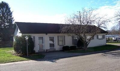
Property Record
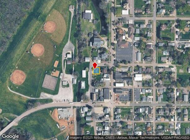
175 N Main St, Magnolia, OH 44643
NEARBY LISTINGS FOR SALE OR LEASE
-
-
View all Magnolia listings for sale on LoopNet.com
Property Detail
175 N Main St
06500536
A R Elsons Add/Vlg/Magnolia
Officebuilding
3 - 63WE (.09A)
X
Stark
39157C0100E
Ohio
0
0.09 AC
2025
Stark County
714902
Cleveland
1,808 SF
Canton-Massillon, OH
DEMOGRAPHICS near 175 N Main St
1 mile
3 mile
5 mile
2024 Total Population
844
4,380
8,283
2029 Population
818
4,237
8,052
Pop Growth 2024-2029
(3.08%)
(3.26%)
(2.79%)
Average Age
41
42
43
2024 Total Households
332
1,728
3,329
HH Growth 2024-2029
(3.01%)
(3.24%)
(2.79%)
Median Household Inc
$69,999
$56,478
$57,573
Avg Household Size
2.50
2.50
2.50
2024 Avg HH Vehicles
2.00
2.00
2.00
Median Home Value
$161,764
$153,647
$153,590
Median Year Built
1952
1961
1961
Nearby Places
Map Layers
Map Styles
 Street
 Aerial
Transit
 Traffic
 Biking
Places
Listings with unknown addresses are not visible on the map
- Restaurants
- Banks
- Shops
- Fitness
- Groceries
PUBLIC TRANSPORTATION
AIRPORT
Akron-Canton Regional
Drive
Walk
Distance
Akron-Canton Regional
36 min
23.8 mi
Nearby Properties
Address
Land Use
TOTAL SIZE
Lot Size
Zoning
Address
Land Use
TOTAL SIZE
Lot Size
Zoning
115,843 SF
27.26 AC
Address
Land Use
TOTAL SIZE
Lot Size
Zoning
27,063 SF
3.22 AC
Address
Land Use
TOTAL SIZE
Lot Size
Zoning
46,256 SF
8.48 AC
Address
Land Use
TOTAL SIZE
Lot Size
Zoning
12,044 SF
6.64 AC
Address
Land Use
TOTAL SIZE
Lot Size
Zoning
8,580 SF
80.48 AC
Address
Land Use
TOTAL SIZE
Lot Size
Zoning
10,444 SF
1.50 AC
Address
Land Use
TOTAL SIZE
Lot Size
Zoning
12,882 SF
4.88 AC
Address
Land Use
TOTAL SIZE
Lot Size
Zoning
1,200 SF
164.42 AC
Address
Land Use
TOTAL SIZE
Lot Size
Zoning
11,532 SF
5.79 AC
Address
Land Use
TOTAL SIZE
Lot Size
Zoning
3,476 SF
35.58 AC
Address
Land Use
TOTAL SIZE
Lot Size
Zoning
4,493 SF
12.12 AC
Address
Land Use
TOTAL SIZE
Lot Size
Zoning
19,725 SF
2.11 AC
Address
Land Use
TOTAL SIZE
Lot Size
Zoning
924 SF
252.74 AC
Address
Land Use
TOTAL SIZE
Lot Size
Zoning
2,896 SF
151.77 AC
Address
Land Use
TOTAL SIZE
Lot Size
Zoning
9,179 SF
2.03 AC
Address
Land Use
TOTAL SIZE
Lot Size
Zoning
246.74 AC
Address
Land Use
TOTAL SIZE
Lot Size
Zoning
1,940 SF
147.91 AC
Address
Land Use
TOTAL SIZE
Lot Size
Zoning
4,313 SF
46.36 AC
Address
Land Use
TOTAL SIZE
Lot Size
Zoning
3,788 SF
46.10 AC
Address
Land Use
TOTAL SIZE
Lot Size
Zoning
3,080 SF
117.47 AC
Address
Land Use
TOTAL SIZE
Lot Size
Zoning
7,880 SF
79.92 AC
Address
Land Use
TOTAL SIZE
Lot Size
Zoning
137.10 AC
Address
Land Use
TOTAL SIZE
Lot Size
Zoning
7,052 SF
2.96 AC
Address
Land Use
TOTAL SIZE
Lot Size
Zoning
22,532 SF
3.49 AC
Address
Land Use
TOTAL SIZE
Lot Size
Zoning
22,532 SF
3.11 AC
Address
Land Use
TOTAL SIZE
Lot Size
Zoning
2,190 SF
81.50 AC
Address
Land Use
TOTAL SIZE
Lot Size
Zoning
46,256 SF
7.11 AC
Address
Land Use
TOTAL SIZE
Lot Size
Zoning
4,123 SF
73.57 AC
Address
Land Use
TOTAL SIZE
Lot Size
Zoning
1,620 SF
100.08 AC
Address
Land Use
TOTAL SIZE
Lot Size
Zoning
5,852 SF
0.45 AC
The World's #1 Commercial Real Estate Marketplace
Connect with us
© 2026 CoStar Group
The information above has been obtained from sources believed reliable. While we do not doubt its accuracy we have not verified it and make no guarantee, warranty or representation about it. It is your responsibility to independently confirm its accuracy and completeness. Any projections, opinions, assumptions, or estimates used are for example only and do not represent the current or future performance of the property. The value of this transaction to you depends on tax and other factors which should be evaluated by your tax, financial, and legal advisors. You and your advisors should conduct a careful, independent investigation of the property to determine to your satisfaction the suitability of the property for your needs.