Property Record
175 N Rufus St, New Haven, IN 46774
NEARBY LISTINGS FOR SALE OR LEASE
Property Detail
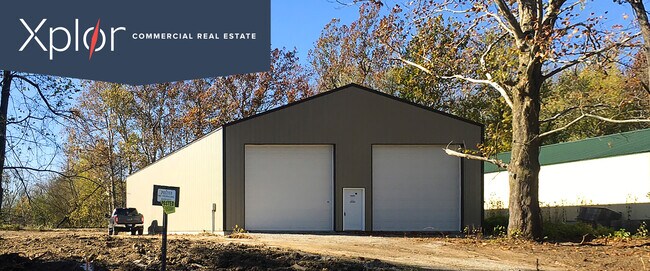
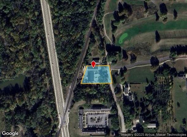
175 N Rufus St
02-13-01-353-002.001-041
Wabash
Warehouse
1.006 AC SPC BET WABASH RR & RUFUS ST SW 1/4 SW 1/4 SEC 1
AE
Allen
18003C0309G
Indiana
2023
1.01 AC
2024
New Haven
011100
Fort Wayne
5,400 SF
Fort Wayne, IN
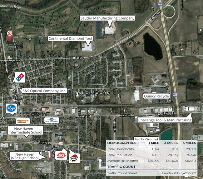
DEMOGRAPHICS near 175 N Rufus St
1 Mile
3 Mile
5 Mile
2024 Total Population
3,886
30,440
78,889
2029 Population
4,074
31,541
81,732
Pop Growth 2024-2029
+ 4.84%
+ 3.62%
+ 3.60%
Average Age
40
40
39
2024 Total Households
1,661
12,269
31,316
HH Growth 2024-2029
+ 4.94%
+ 3.66%
+ 3.63%
Median Household Inc
$55,084
$61,452
$61,369
Avg Household Size
2.30
2.40
2.40
2024 Avg HH Vehicles
2.00
2.00
2.00
Median Home Value
$130,218
$154,629
$157,036
Median Year Built
1958
1975
1973
Nearby Places
Map Layers
Map Styles
 Street
 Aerial
- Restaurants
- Banks
- Shops
- Fitness
- Groceries
PUBLIC TRANSPORTATION
AIRPORT
Fort Wayne International
DRIVE
WALK
Distance
Fort Wayne International
32 min
20.8 mi
Freight Ports
Port of Toledo
DRIVE
WALK
Distance
Port of Toledo
126 min
98.2 mi
SALE & LEASE HISTORY
LISTING DATE
SALE/LEASE

Mar 03, 2021
For Lease
Nearby Properties
Address
Land Use
TOTAL SIZE
Lot Size
Zoning
Address
Land Use
TOTAL SIZE
Lot Size
Zoning
23,326 SF
15.27 AC
Address
Land Use
TOTAL SIZE
Lot Size
Zoning
183,230 SF
34.24 AC
Address
Land Use
TOTAL SIZE
Lot Size
Zoning
215,768 SF
23.56 AC
Address
Land Use
TOTAL SIZE
Lot Size
Zoning
180,813 SF
24.60 AC
Address
Land Use
TOTAL SIZE
Lot Size
Zoning
154,746 SF
8.75 AC
Address
Land Use
TOTAL SIZE
Lot Size
Zoning
72,240 SF
9.41 AC
Address
Land Use
TOTAL SIZE
Lot Size
Zoning
237,829 SF
49.86 AC
Address
Land Use
TOTAL SIZE
Lot Size
Zoning
126,495 SF
9.28 AC
Address
Land Use
TOTAL SIZE
Lot Size
Zoning
70,312 SF
25.22 AC
Address
Land Use
TOTAL SIZE
Lot Size
Zoning
145,580 SF
8.15 AC
Address
Land Use
TOTAL SIZE
Lot Size
Zoning
97,329 SF
34.53 AC
Address
Land Use
TOTAL SIZE
Lot Size
Zoning
94,015 SF
9.45 AC
Address
Land Use
TOTAL SIZE
Lot Size
Zoning
105,868 SF
13.42 AC
Address
Land Use
TOTAL SIZE
Lot Size
Zoning
142,983 SF
10.02 AC
Address
Land Use
TOTAL SIZE
Lot Size
Zoning
106,164 SF
10.34 AC
Address
Land Use
TOTAL SIZE
Lot Size
Zoning
118,956 SF
36.27 AC
Address
Land Use
TOTAL SIZE
Lot Size
Zoning
96,315 SF
8.33 AC
Address
Land Use
TOTAL SIZE
Lot Size
Zoning
57,932 SF
11.71 AC
Address
Land Use
TOTAL SIZE
Lot Size
Zoning
16,250 SF
2.02 AC
Address
Land Use
TOTAL SIZE
Lot Size
Zoning
465,944 SF
27.48 AC
Address
Land Use
TOTAL SIZE
Lot Size
Zoning
123,852 SF
9.40 AC
Address
Land Use
TOTAL SIZE
Lot Size
Zoning
68,547 SF
11.50 AC
Address
Land Use
TOTAL SIZE
Lot Size
Zoning
67,800 SF
6.12 AC
Address
Land Use
TOTAL SIZE
Lot Size
Zoning
403,420 SF
14.46 AC
Address
Land Use
TOTAL SIZE
Lot Size
Zoning
68,220 SF
9.67 AC
Address
Land Use
TOTAL SIZE
Lot Size
Zoning
39,300 SF
4.44 AC
Address
Land Use
TOTAL SIZE
Lot Size
Zoning
48,360 SF
15 AC
Address
Land Use
TOTAL SIZE
Lot Size
Zoning
68,452 SF
9.95 AC
Address
Land Use
TOTAL SIZE
Lot Size
Zoning
37,711 SF
6.57 AC
Address
Land Use
TOTAL SIZE
Lot Size
Zoning
33,472 SF
3.51 AC
The World's #1 Commercial Real Estate Marketplace
Connect with us
© 2025 CoStar Group
The information above has been obtained from sources believed reliable. While we do not doubt its accuracy we have not verified it and make no guarantee, warranty or representation about it. It is your responsibility to independently confirm its accuracy and completeness. Any projections, opinions, assumptions, or estimates used are for example only and do not represent the current or future performance of the property. The value of this transaction to you depends on tax and other factors which should be evaluated by your tax, financial, and legal advisors. You and your advisors should conduct a careful, independent investigation of the property to determine to your satisfaction the suitability of the property for your needs.