Property Record
175 Patterson Ave, Shrewsbury, NJ 07702
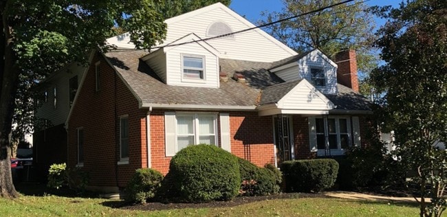


Property Detail
175 Patterson Ave
44-00002-0000-00003
Monmouth
Commercialofficeresidentialmixeduse
New Jersey
MU0
3
B and X Area of moderate flood hazard, usually the area between the limits of the 100-year and 500-year floods.
0.39 AC
2024
Eastern Monmouth
2025
Northern New Jersey
812300
Lakewood-New Brunswick, NJ
3,355 SF
NEARBY LISTINGS FOR SALE OR LEASE
DEMOGRAPHICS near 175 Patterson Ave
1 mile
3 mile
5 mile
2025 Total Population
11,207
62,964
131,676
2030 Population
11,114
62,730
131,157
Pop Growth 2025-2030
(0.83%)
(0.37%)
(0.39%)
Average Age
40
43
42
2025 Total Households
3,995
24,752
49,198
HH Growth 2025-2030
(0.88%)
(0.48%)
(0.52%)
Median Household Inc
$102,670
$120,149
$122,192
Avg Household Size
2.70
2.50
2.60
2025 Avg HH Vehicles
2.00
2.00
2.00
Median Home Value
$627,419
$704,685
$739,337
Median Year Built
1953
1966
1970
Nearby Places
Map Layers
Map Styles
 Street
 Aerial
Layers
 Traffic
 Biking
Places
Listings with unknown addresses are not visible on the map
- Restaurants
- Banks
- Shops
- Fitness
- Groceries
PUBLIC TRANSPORTATION
COMMUTER RAIL
Red Bank (North Jersey Coast Line - NJ Transit Commuter Rail (NJ Transit))
Drive
Walk
Distance
Red Bank (North Jersey Coast Line - NJ Transit Commuter Rail (NJ Transit))
3 min
1.2 mi
Little Silver (North Jersey Coast Line - NJ Transit Commuter Rail (NJ Transit))
Drive
Walk
Distance
Little Silver (North Jersey Coast Line - NJ Transit Commuter Rail (NJ Transit))
5 min
2.3 mi
AIRPORT
Newark Liberty International
Drive
Walk
Distance
Newark Liberty International
53 min
38.5 mi
Freight Ports
New York Container Terminal
Drive
Walk
Distance
New York Container Terminal
46 min
33.0 mi
SALE & LEASE HISTORY
LISTING DATE
SALE/LEASE

Dec 04, 2018
For Sale
Nearby Properties
Address
Land Use
TOTAL SIZE
Lot Size
Zoning
Address
Land Use
TOTAL SIZE
Lot Size
Zoning
221.56 AC
CONREC
Address
Land Use
TOTAL SIZE
Lot Size
Zoning
427,320 SF
5.58 AC
MS
Address
Land Use
TOTAL SIZE
Lot Size
Zoning
Address
Land Use
TOTAL SIZE
Lot Size
Zoning
84,653 SF
20.79 AC
C50
Address
Land Use
TOTAL SIZE
Lot Size
Zoning
24.45 AC
MF08
Address
Land Use
TOTAL SIZE
Lot Size
Zoning
199,680 SF
44 SF
MU08
Address
Land Use
TOTAL SIZE
Lot Size
Zoning
22,980 SF
5.27 AC
MU0
Address
Land Use
TOTAL SIZE
Lot Size
Zoning
128,279 SF
1.92 AC
WD
Address
Land Use
TOTAL SIZE
Lot Size
Zoning
251,314 SF
53.63 AC
R-1A
Address
Land Use
TOTAL SIZE
Lot Size
Zoning
178,315 SF
24.54 AC
C50
Address
Land Use
TOTAL SIZE
Lot Size
Zoning
154,970 SF
1.83 AC
BR-1
Address
Land Use
TOTAL SIZE
Lot Size
Zoning
75,046 SF
6.06 AC
OB01
Address
Land Use
TOTAL SIZE
Lot Size
Zoning
27 AC
MF08
Address
Land Use
TOTAL SIZE
Lot Size
Zoning
241,154 SF
84 AC
SF20
Address
Land Use
TOTAL SIZE
Lot Size
Zoning
181,867 SF
31.90 AC
RA
Address
Land Use
TOTAL SIZE
Lot Size
Zoning
12,269 SF
3.60 AC
OVERLAY
Address
Land Use
TOTAL SIZE
Lot Size
Zoning
2,166 SF
77.43 AC
CONREC
Address
Land Use
TOTAL SIZE
Lot Size
Zoning
97,572 SF
2.57 AC
MU08
Address
Land Use
TOTAL SIZE
Lot Size
Zoning
201,791 SF
10.50 AC
B3
Address
Land Use
TOTAL SIZE
Lot Size
Zoning
14.99 AC
MF08
Address
Land Use
TOTAL SIZE
Lot Size
Zoning
91,564 SF
2.45 AC
BR-1
Address
Land Use
TOTAL SIZE
Lot Size
Zoning
14.73 AC
MF08
Address
Land Use
TOTAL SIZE
Lot Size
Zoning
101,880 SF
6 AC
SF05
Address
Land Use
TOTAL SIZE
Lot Size
Zoning
83.83 AC
BR-1
Address
Land Use
TOTAL SIZE
Lot Size
Zoning
36.22 AC
SF10
Address
Land Use
TOTAL SIZE
Lot Size
Zoning
86,586 SF
4.83 AC
R-4
Address
Land Use
TOTAL SIZE
Lot Size
Zoning
153,006 SF
3.52 AC
MF24
Address
Land Use
TOTAL SIZE
Lot Size
Zoning
30,000 SF
10.03 AC
I0
Address
Land Use
TOTAL SIZE
Lot Size
Zoning
74,870 SF
2.34 AC
MS
Address
Land Use
TOTAL SIZE
Lot Size
Zoning
73,032 SF
7.30 AC
B1
The World's #1 Commercial Real Estate Marketplace
Connect with us
© 2026 CoStar Group
The information above has been obtained from sources believed reliable. While we do not doubt its accuracy we have not verified it and make no guarantee, warranty or representation about it. It is your responsibility to independently confirm its accuracy and completeness. Any projections, opinions, assumptions, or estimates used are for example only and do not represent the current or future performance of the property. The value of this transaction to you depends on tax and other factors which should be evaluated by your tax, financial, and legal advisors. You and your advisors should conduct a careful, independent investigation of the property to determine to your satisfaction the suitability of the property for your needs.