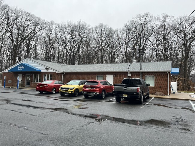
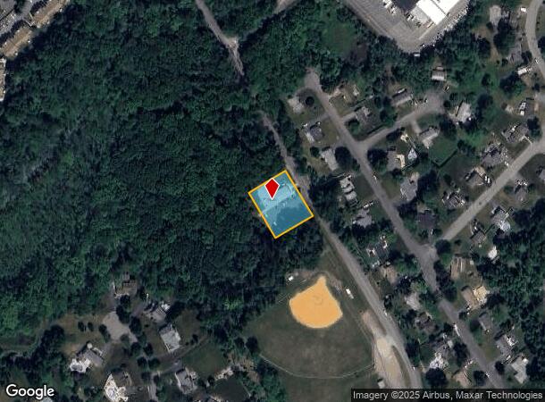
Property Record
175 Righter Rd, Succasunna, NJ 07876
This Property Is For Sale
NEARBY LISTINGS FOR SALE OR LEASE
Property Detail
175 Righter Rd
Northern New Jersey
Township/Roxbury
Newark, NJ-PA
FACILITY NAME: DIALYSIS CENTER
36-04901-0000-00003
Morris
Governmentalpublicusegeneral
New Jersey
0
3
2025
0.60 AC
045503
Western Morris
4,704 SF
DEMOGRAPHICS near 175 Righter Rd
1 Mile
3 Mile
5 Mile
2024 Total Population
6,562
33,754
105,238
2029 Population
6,685
34,505
107,885
Pop Growth 2024-2029
+ 1.87%
+ 2.22%
+ 2.52%
Average Age
44
43
42
2024 Total Households
2,557
12,660
39,373
HH Growth 2024-2029
+ 1.92%
+ 2.20%
+ 2.58%
Median Household Inc
$120,051
$143,014
$120,453
Avg Household Size
2.50
2.60
2.60
2024 Avg HH Vehicles
2.00
2.00
2.00
Median Home Value
$450,665
$474,249
$447,818
Median Year Built
1980
1976
1972
Nearby Places
- Restaurants
- Banks
- Shops
- Fitness
- Groceries
PUBLIC TRANSPORTATION
COMMUTER RAIL
Mount Arlington (Montclair-Boonton Line - NJ Transit Commuter Rail (NJ Transit), Morris & Essex Morristown Line - NJ Transit Commuter Rail (NJ Transit))
DRIVE
WALK
Distance
Mount Arlington (Montclair-Boonton Line - NJ Transit Commuter Rail (NJ Transit), Morris & Essex Morristown Line - NJ Transit Commuter Rail (NJ Transit))
6 min
2.9 mi
Lake Hopatcong (Montclair-Boonton Line - NJ Transit Commuter Rail (NJ Transit), Morris & Essex Morristown Line - NJ Transit Commuter Rail (NJ Transit))
DRIVE
WALK
Distance
Lake Hopatcong (Montclair-Boonton Line - NJ Transit Commuter Rail (NJ Transit), Morris & Essex Morristown Line - NJ Transit Commuter Rail (NJ Transit))
7 min
3.6 mi
AIRPORT
Newark Liberty International
DRIVE
WALK
Distance
Newark Liberty International
45 min
35.0 mi
Freight Ports
Maher Terminal
DRIVE
WALK
Distance
Maher Terminal
50 min
36.1 mi
Nearby Properties
Address
Land Use
TOTAL SIZE
Lot Size
Zoning
Address
Land Use
TOTAL SIZE
Lot Size
Zoning
174.40 AC
R-5
Address
Land Use
TOTAL SIZE
Lot Size
Zoning
Address
Land Use
TOTAL SIZE
Lot Size
Zoning
25.63 AC
B-3
Address
Land Use
TOTAL SIZE
Lot Size
Zoning
56.90 AC
Address
Land Use
TOTAL SIZE
Lot Size
Zoning
23.74 AC
B-3
Address
Land Use
TOTAL SIZE
Lot Size
Zoning
1,017 SF
1,485.15 AC
P
Address
Land Use
TOTAL SIZE
Lot Size
Zoning
276,378 SF
40.50 AC
OSGU
Address
Land Use
TOTAL SIZE
Lot Size
Zoning
72.81 AC
LIOR
Address
Land Use
TOTAL SIZE
Lot Size
Zoning
8.19 AC
B-3
Address
Land Use
TOTAL SIZE
Lot Size
Zoning
440.89 AC
POLI
Address
Land Use
TOTAL SIZE
Lot Size
Zoning
6.74 AC
TC
Address
Land Use
TOTAL SIZE
Lot Size
Zoning
457,072 SF
64.13 AC
I-1
Address
Land Use
TOTAL SIZE
Lot Size
Zoning
126,875 SF
7.02 AC
Address
Land Use
TOTAL SIZE
Lot Size
Zoning
55.26 AC
PUD
Address
Land Use
TOTAL SIZE
Lot Size
Zoning
42.43 AC
R-5
Address
Land Use
TOTAL SIZE
Lot Size
Zoning
79,962 SF
27.80 AC
GU
Address
Land Use
TOTAL SIZE
Lot Size
Zoning
22,289 SF
5 AC
R1
Address
Land Use
TOTAL SIZE
Lot Size
Zoning
20.85 AC
I-3
Address
Land Use
TOTAL SIZE
Lot Size
Zoning
8.43 AC
B-3
Address
Land Use
TOTAL SIZE
Lot Size
Zoning
68,844 SF
5 AC
PUD
Address
Land Use
TOTAL SIZE
Lot Size
Zoning
4,200 SF
34.12 AC
GU
Address
Land Use
TOTAL SIZE
Lot Size
Zoning
133,934 SF
21.46 AC
PUD
Address
Land Use
TOTAL SIZE
Lot Size
Zoning
65,128 SF
1.69 AC
B-2
Address
Land Use
TOTAL SIZE
Lot Size
Zoning
1.95 AC
PO/R
Address
Land Use
TOTAL SIZE
Lot Size
Zoning
165,000 SF
27.57 AC
I2
Address
Land Use
TOTAL SIZE
Lot Size
Zoning
68,586 SF
15 AC
R1
Address
Land Use
TOTAL SIZE
Lot Size
Zoning
36.07 AC
I
Address
Land Use
TOTAL SIZE
Lot Size
Zoning
98,528 SF
10.05 AC
PUD
Address
Land Use
TOTAL SIZE
Lot Size
Zoning
43,869 SF
5.19 AC
B-2
Address
Land Use
TOTAL SIZE
Lot Size
Zoning
87,970 SF
6.56 AC
PUD
The World's #1 Commercial Real Estate Marketplace
Connect with us
© 2025 CoStar Group
The information above has been obtained from sources believed reliable. While we do not doubt its accuracy we have not verified it and make no guarantee, warranty or representation about it. It is your responsibility to independently confirm its accuracy and completeness. Any projections, opinions, assumptions, or estimates used are for example only and do not represent the current or future performance of the property. The value of this transaction to you depends on tax and other factors which should be evaluated by your tax, financial, and legal advisors. You and your advisors should conduct a careful, independent investigation of the property to determine to your satisfaction the suitability of the property for your needs.