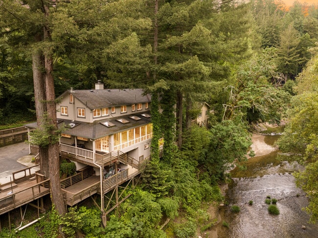
Property Record
175 Shadowbrook Rd, Ben Lomond, CA 95005

Property Detail
175 Shadowbrook Rd
Multifamilydwelling
Santa Cruz
R-1-1AC
California
AE The base floodplain where base flood elevations are provided. AE Zones are now used on new format FIRMs instead of A1-A30 Zones.
1.09 AC
0
Outlying Santa Cruz County
2025
Santa Cruz/Watsonville
1203022020
Santa Cruz-Watsonville, CA
400 SF
077-251-39-000
NEARBY LISTINGS FOR SALE OR LEASE
DEMOGRAPHICS near 175 Shadowbrook Rd
1 mile
3 mile
5 mile
2025 Total Population
4,316
12,691
33,204
2030 Population
4,087
11,950
31,668
Pop Growth 2025-2030
(5.31%)
(5.84%)
(4.63%)
Average Age
45
45
44
2025 Total Households
1,676
4,901
12,858
HH Growth 2025-2030
(5.91%)
(6.49%)
(5.14%)
Median Household Inc
$110,969
$115,281
$122,325
Avg Household Size
2.50
2.50
2.50
2025 Avg HH Vehicles
2.00
2.00
2.00
Median Home Value
$913,729
$874,999
$976,391
Median Year Built
1964
1963
1971
Nearby Places
Map Layers
Map Styles
 Street
 Aerial
Layers
 Traffic
 Biking
Places
Listings with unknown addresses are not visible on the map
- Restaurants
- Banks
- Shops
- Fitness
- Groceries
PUBLIC TRANSPORTATION
AIRPORT
Norman Y Mineta San Jose International
Drive
Walk
Distance
Norman Y Mineta San Jose International
51 min
33.8 mi
Freight Ports
Port of Redwood City
Drive
Walk
Distance
Port of Redwood City
71 min
49.7 mi
SALE & LEASE HISTORY
LISTING DATE
SALE/LEASE

Jun 22, 2023
For Sale
Nearby Properties
Address
Land Use
TOTAL SIZE
Lot Size
Zoning
Address
Land Use
TOTAL SIZE
Lot Size
Zoning
992 SF
5.45 AC
PR
Address
Land Use
TOTAL SIZE
Lot Size
Zoning
6,098 SF
14.59 AC
PR-GH
Address
Land Use
TOTAL SIZE
Lot Size
Zoning
1,052 SF
0.41 AC
SU-GH
Address
Land Use
TOTAL SIZE
Lot Size
Zoning
6,302 SF
7.37 AC
PR
Address
Land Use
TOTAL SIZE
Lot Size
Zoning
116.88 AC
RA-GH
Address
Land Use
TOTAL SIZE
Lot Size
Zoning
1.57 AC
PR
Address
Land Use
TOTAL SIZE
Lot Size
Zoning
34,300 SF
29.46 AC
Address
Land Use
TOTAL SIZE
Lot Size
Zoning
1.73 AC
PR-L
Address
Land Use
TOTAL SIZE
Lot Size
Zoning
47,216 SF
6.07 AC
C-2-GH
Address
Land Use
TOTAL SIZE
Lot Size
Zoning
2,480 SF
90.93 AC
SU
Address
Land Use
TOTAL SIZE
Lot Size
Zoning
9,543 SF
5.21 AC
VA
Address
Land Use
TOTAL SIZE
Lot Size
Zoning
29,115 SF
1.05 AC
C-1
Address
Land Use
TOTAL SIZE
Lot Size
Zoning
8,312 SF
7.37 AC
RA
Address
Land Use
TOTAL SIZE
Lot Size
Zoning
5,259 SF
90.59 AC
SU
Address
Land Use
TOTAL SIZE
Lot Size
Zoning
4.20 AC
SU
Address
Land Use
TOTAL SIZE
Lot Size
Zoning
6,194 SF
1.99 AC
Address
Land Use
TOTAL SIZE
Lot Size
Zoning
0.65 AC
C-2
Address
Land Use
TOTAL SIZE
Lot Size
Zoning
1,440 SF
23.61 AC
SU
Address
Land Use
TOTAL SIZE
Lot Size
Zoning
2,401 SF
R-1-1AC
Address
Land Use
TOTAL SIZE
Lot Size
Zoning
30.94 AC
R-1-15
Address
Land Use
TOTAL SIZE
Lot Size
Zoning
3,270 SF
113.46 AC
PR
Address
Land Use
TOTAL SIZE
Lot Size
Zoning
65.10 AC
PR-O
Address
Land Use
TOTAL SIZE
Lot Size
Zoning
6,166 SF
17.89 AC
RA
Address
Land Use
TOTAL SIZE
Lot Size
Zoning
7,563 SF
1.19 AC
SU-GH
Address
Land Use
TOTAL SIZE
Lot Size
Zoning
4,723 SF
5.13 AC
RA
Address
Land Use
TOTAL SIZE
Lot Size
Zoning
9,199 SF
24.52 AC
SU
Address
Land Use
TOTAL SIZE
Lot Size
Zoning
3,691 SF
0.52 AC
C-2
Address
Land Use
TOTAL SIZE
Lot Size
Zoning
2.60 AC
PR
The World's #1 Commercial Real Estate Marketplace
Connect with us
© 2026 CoStar Group
The information above has been obtained from sources believed reliable. While we do not doubt its accuracy we have not verified it and make no guarantee, warranty or representation about it. It is your responsibility to independently confirm its accuracy and completeness. Any projections, opinions, assumptions, or estimates used are for example only and do not represent the current or future performance of the property. The value of this transaction to you depends on tax and other factors which should be evaluated by your tax, financial, and legal advisors. You and your advisors should conduct a careful, independent investigation of the property to determine to your satisfaction the suitability of the property for your needs.