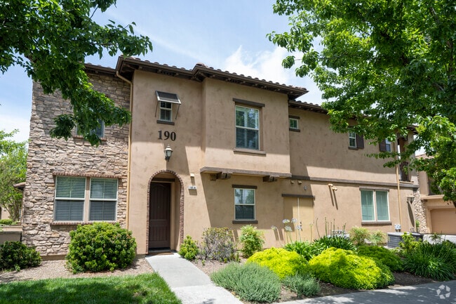
Property Record
175 Stonegate Cir, Cloverdale, CA 95425

NEARBY LISTINGS FOR SALE OR LEASE
-
-
View all Cloverdale listings for sale on LoopNet.com
Property Detail
175 Stonegate Cir
Santa Rosa-Petaluma, CA
The Gardens At Thyme Square Subdivision
001-440-016
2006 FM 001-440-001 GARDENS AT THYME SQR UNIT U29
Condominium
Sonoma
X
California
06045C2050F
1
2024
0.03 AC
2025
Northeast Sonoma County
154202
North Bay/Santa Rosa
1,266 SF
DEMOGRAPHICS near 175 Stonegate Cir
1 mile
3 mile
5 mile
2024 Total Population
8,141
10,681
11,143
2029 Population
8,113
10,596
11,038
Pop Growth 2024-2029
(0.34%)
(0.80%)
(0.94%)
Average Age
42
43
44
2024 Total Households
2,975
4,028
4,216
HH Growth 2024-2029
(0.37%)
(0.89%)
(1.07%)
Median Household Inc
$92,466
$94,492
$96,350
Avg Household Size
2.70
2.60
2.60
2024 Avg HH Vehicles
2.00
2.00
2.00
Median Home Value
$636,709
$668,292
$679,347
Median Year Built
1975
1977
1977
Nearby Places
Map Layers
Map Styles
 Street
 Aerial
Transit
 Traffic
 Biking
Places
Listings with unknown addresses are not visible on the map
- Restaurants
- Banks
- Shops
- Fitness
- Groceries
PUBLIC TRANSPORTATION
AIRPORT
Charles M Schulz - Sonoma County
Drive
Walk
Distance
Charles M Schulz - Sonoma County
35 min
27.4 mi
Freight Ports
Port of Richmond
Drive
Walk
Distance
Port of Richmond
100 min
80.3 mi
Nearby Properties
Address
Land Use
TOTAL SIZE
Lot Size
Zoning
Address
Land Use
TOTAL SIZE
Lot Size
Zoning
99,570 SF
4.41 AC
Address
Land Use
TOTAL SIZE
Lot Size
Zoning
62,655 SF
16.74 AC
M2
Address
Land Use
TOTAL SIZE
Lot Size
Zoning
2.56 AC
Address
Land Use
TOTAL SIZE
Lot Size
Zoning
240.83 AC
Address
Land Use
TOTAL SIZE
Lot Size
Zoning
10.28 AC
CITYCL
Address
Land Use
TOTAL SIZE
Lot Size
Zoning
15,756 SF
1.45 AC
Address
Land Use
TOTAL SIZE
Lot Size
Zoning
43,987 SF
1.52 AC
Address
Land Use
TOTAL SIZE
Lot Size
Zoning
63,840 SF
4.09 AC
Address
Land Use
TOTAL SIZE
Lot Size
Zoning
40,832 SF
0.20 AC
Address
Land Use
TOTAL SIZE
Lot Size
Zoning
6,684 SF
20.42 AC
1NDL
Address
Land Use
TOTAL SIZE
Lot Size
Zoning
Address
Land Use
TOTAL SIZE
Lot Size
Zoning
4.69 AC
Address
Land Use
TOTAL SIZE
Lot Size
Zoning
28,610 SF
1.36 AC
Address
Land Use
TOTAL SIZE
Lot Size
Zoning
21,826 SF
30.68 AC
RRDW20
Address
Land Use
TOTAL SIZE
Lot Size
Zoning
51.26 AC
LIA20
Address
Land Use
TOTAL SIZE
Lot Size
Zoning
15,841 SF
0.72 AC
Address
Land Use
TOTAL SIZE
Lot Size
Zoning
1,334 SF
84 AC
RRDB8FRZN
Address
Land Use
TOTAL SIZE
Lot Size
Zoning
2.64 AC
Address
Land Use
TOTAL SIZE
Lot Size
Zoning
3,504 SF
42.91 AC
M3
Address
Land Use
TOTAL SIZE
Lot Size
Zoning
Address
Land Use
TOTAL SIZE
Lot Size
Zoning
53,692 SF
3.23 AC
Address
Land Use
TOTAL SIZE
Lot Size
Zoning
2,250 SF
9.30 AC
LIA20
Address
Land Use
TOTAL SIZE
Lot Size
Zoning
42,278 SF
5.70 AC
M3
Address
Land Use
TOTAL SIZE
Lot Size
Zoning
25,520 SF
1.56 AC
CITYCL
Address
Land Use
TOTAL SIZE
Lot Size
Zoning
42,822 SF
12.17 AC
M1B8FRZN
Address
Land Use
TOTAL SIZE
Lot Size
Zoning
Address
Land Use
TOTAL SIZE
Lot Size
Zoning
30,142 SF
2.05 AC
Address
Land Use
TOTAL SIZE
Lot Size
Zoning
72,420 SF
3.58 AC
MP
Address
Land Use
TOTAL SIZE
Lot Size
Zoning
6,469 SF
14.68 AC
Address
Land Use
TOTAL SIZE
Lot Size
Zoning
115,200 SF
7.85 AC
MP
The World's #1 Commercial Real Estate Marketplace
Connect with us
© 2026 CoStar Group
The information above has been obtained from sources believed reliable. While we do not doubt its accuracy we have not verified it and make no guarantee, warranty or representation about it. It is your responsibility to independently confirm its accuracy and completeness. Any projections, opinions, assumptions, or estimates used are for example only and do not represent the current or future performance of the property. The value of this transaction to you depends on tax and other factors which should be evaluated by your tax, financial, and legal advisors. You and your advisors should conduct a careful, independent investigation of the property to determine to your satisfaction the suitability of the property for your needs.