Property Record
175 Wolfe Rd, Ortonville, MI 48462
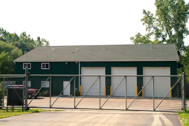


Property Detail
175 Wolfe Rd
03-18-352-036
T5N, R9E, SEC 18 ARNASON SUB LOTS 12 & 13 EXC S 250 FT OF BOTH SD LOTS, ALSO E 1/2 OF LOT 14 EXC S 250 FT 9-27-96 FR 032, 033 & 034
Warehouse
Oakland
AI
Michigan
A Areas with a 1% annual chance of flooding and a 26% chance of flooding over the life of a 30-year mortgage.
12-14
2024
2.52 AC
2025
St Clair & Lapeer Counties
122700
Detroit
5,120 SF
Detroit-Warren-Dearborn, MI
NEARBY LISTINGS FOR SALE OR LEASE
-
-
View all Ortonville listings for sale on LoopNet.com
DEMOGRAPHICS near 175 Wolfe Rd
1 mile
3 mile
5 mile
2025 Total Population
1,873
9,685
23,784
2030 Population
1,962
10,030
24,469
Pop Growth 2025-2030
+ 4.75%
+ 3.56%
+ 2.88%
Average Age
44
44
43
2025 Total Households
710
3,640
8,762
HH Growth 2025-2030
+ 4.93%
+ 3.71%
+ 3.00%
Median Household Inc
$99,924
$101,597
$103,563
Avg Household Size
2.60
2.60
2.70
2025 Avg HH Vehicles
2.00
3.00
2.00
Median Home Value
$318,590
$329,706
$349,120
Median Year Built
1978
1979
1986
Nearby Places
Map Layers
Map Styles
 Street
 Aerial
Transit
 Traffic
 Biking
Places
Listings with unknown addresses are not visible on the map
- Restaurants
- Banks
- Shops
- Fitness
- Groceries
PUBLIC TRANSPORTATION
AIRPORT
Bishop International
Drive
Walk
Distance
Bishop International
44 min
22.1 mi
Freight Ports
Port of Toledo
Drive
Walk
Distance
Port of Toledo
124 min
93.8 mi
Nearby Properties
Address
Land Use
TOTAL SIZE
Lot Size
Zoning
Address
Land Use
TOTAL SIZE
Lot Size
Zoning
73,164 SF
12.27 AC
BI
Address
Land Use
TOTAL SIZE
Lot Size
Zoning
352.82 AC
REC
Address
Land Use
TOTAL SIZE
Lot Size
Zoning
53,794 SF
10.04 AC
Address
Land Use
TOTAL SIZE
Lot Size
Zoning
22,981 SF
2.63 AC
AI
Address
Land Use
TOTAL SIZE
Lot Size
Zoning
19,344 SF
2.63 AC
AI
Address
Land Use
TOTAL SIZE
Lot Size
Zoning
31,813 SF
68.53 AC
FI
Address
Land Use
TOTAL SIZE
Lot Size
Zoning
46,800 SF
2.71 AC
AI
Address
Land Use
TOTAL SIZE
Lot Size
Zoning
11,197 SF
2.35 AC
BI
Address
Land Use
TOTAL SIZE
Lot Size
Zoning
23,326 SF
4.35 AC
AI
Address
Land Use
TOTAL SIZE
Lot Size
Zoning
75,000 SF
20.27 AC
AI
Address
Land Use
TOTAL SIZE
Lot Size
Zoning
12,060 SF
2.30 AC
AI
Address
Land Use
TOTAL SIZE
Lot Size
Zoning
12,800 SF
14.24 AC
Address
Land Use
TOTAL SIZE
Lot Size
Zoning
17,363 SF
68.53 AC
FI
Address
Land Use
TOTAL SIZE
Lot Size
Zoning
17,031 SF
5.02 AC
AI
Address
Land Use
TOTAL SIZE
Lot Size
Zoning
1,368 SF
69.35 AC
AI
Address
Land Use
TOTAL SIZE
Lot Size
Zoning
3,291 SF
1.83 AC
AI
Address
Land Use
TOTAL SIZE
Lot Size
Zoning
4,120 SF
1.39 AC
AI
Address
Land Use
TOTAL SIZE
Lot Size
Zoning
7,800 SF
2.50 AC
AI
Address
Land Use
TOTAL SIZE
Lot Size
Zoning
31,220 SF
1.61 AC
AI
Address
Land Use
TOTAL SIZE
Lot Size
Zoning
5,137 SF
4.74 AC
Address
Land Use
TOTAL SIZE
Lot Size
Zoning
3,822 SF
Address
Land Use
TOTAL SIZE
Lot Size
Zoning
3,822 SF
0.76 AC
AI
Address
Land Use
TOTAL SIZE
Lot Size
Zoning
5,992 SF
1.47 AC
AI
Address
Land Use
TOTAL SIZE
Lot Size
Zoning
9,294 SF
1.93 AC
AI
Address
Land Use
TOTAL SIZE
Lot Size
Zoning
3,680 SF
1.52 AC
AI
Address
Land Use
TOTAL SIZE
Lot Size
Zoning
66.44 AC
Address
Land Use
TOTAL SIZE
Lot Size
Zoning
24,200 SF
2.49 AC
AI
Address
Land Use
TOTAL SIZE
Lot Size
Zoning
3,300 SF
0.42 AC
AI
Address
Land Use
TOTAL SIZE
Lot Size
Zoning
5,890 SF
4.87 AC
AI
Address
Land Use
TOTAL SIZE
Lot Size
Zoning
9,900 SF
0.79 AC
AI
The World's #1 Commercial Real Estate Marketplace
Connect with us
© 2026 CoStar Group
The information above has been obtained from sources believed reliable. While we do not doubt its accuracy we have not verified it and make no guarantee, warranty or representation about it. It is your responsibility to independently confirm its accuracy and completeness. Any projections, opinions, assumptions, or estimates used are for example only and do not represent the current or future performance of the property. The value of this transaction to you depends on tax and other factors which should be evaluated by your tax, financial, and legal advisors. You and your advisors should conduct a careful, independent investigation of the property to determine to your satisfaction the suitability of the property for your needs.