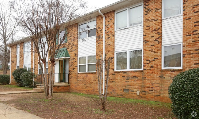
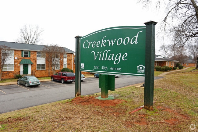
Property Record
1750 40Th Ave, Tuscaloosa, AL 35401


NEARBY LISTINGS FOR SALE OR LEASE
-
-
View all Tuscaloosa listings for sale on LoopNet.com
Property Detail
1750 40Th Ave
Tuscaloosa, AL
College Hills
31-08-28-2-004-028.000
BEG. N. E. COR. LOT 1 BLK. E COLLEGE HILLS SUB PB 9/25 N. 15' TO P.O.B. N. 1055.6', S.W. 496', S. 931.2', E. 485.3' TO POB
Apartment
Tuscaloosa
X
Alabama
01125C0504F
1
2025
11.10 AC
2024
West Tuscaloosa
011703
Birmingham
6,882 SF
DEMOGRAPHICS near 1750 40Th Ave
1 Mile
3 Mile
5 Mile
2024 Total Population
8,036
51,159
115,650
2029 Population
9,240
58,644
130,163
Pop Growth 2024-2029
+ 14.98%
+ 14.63%
+ 12.55%
Average Age
38
35
34
2024 Total Households
2,981
20,477
43,855
HH Growth 2024-2029
+ 13.92%
+ 15.68%
+ 14.42%
Median Household Inc
$29,100
$29,496
$40,621
Avg Household Size
2.40
2.10
2.10
2024 Avg HH Vehicles
1.00
1.00
2.00
Median Home Value
$132,742
$178,144
$194,893
Median Year Built
1967
1983
1988
Nearby Places
Map Layers
Map Styles
 Street
 Aerial
- Restaurants
- Banks
- Shops
- Fitness
- Groceries
PUBLIC TRANSPORTATION
COMMUTER RAIL
Tuscaloosa Amtrak Station (Crescent - Amtrak)
DRIVE
WALK
Distance
Tuscaloosa Amtrak Station (Crescent - Amtrak)
4 min
2.2 mi
Freight Ports
Port of Mobile
DRIVE
WALK
Distance
Port of Mobile
239 min
198.7 mi
Nearby Properties
Address
Land Use
TOTAL SIZE
Lot Size
Zoning
Address
Land Use
TOTAL SIZE
Lot Size
Zoning
148,656 SF
2.79 AC
BC
Address
Land Use
TOTAL SIZE
Lot Size
Zoning
252,793 SF
2.73 AC
BN
Address
Land Use
TOTAL SIZE
Lot Size
Zoning
25,920 SF
16 AC
RMF1
Address
Land Use
TOTAL SIZE
Lot Size
Zoning
6,579 SF
15.07 AC
RMF1
Address
Land Use
TOTAL SIZE
Lot Size
Zoning
160,989 SF
1.53 AC
RMF2
Address
Land Use
TOTAL SIZE
Lot Size
Zoning
1.33 AC
BC
Address
Land Use
TOTAL SIZE
Lot Size
Zoning
176,360 SF
1.13 AC
RMF2
Address
Land Use
TOTAL SIZE
Lot Size
Zoning
200,388 SF
1.22 AC
Address
Land Use
TOTAL SIZE
Lot Size
Zoning
24,360 SF
142 AC
Address
Land Use
TOTAL SIZE
Lot Size
Zoning
110,337 SF
0.91 AC
RMF2
Address
Land Use
TOTAL SIZE
Lot Size
Zoning
105,728 SF
4.75 AC
BGO
Address
Land Use
TOTAL SIZE
Lot Size
Zoning
121,384 SF
21 AC
O-I
Address
Land Use
TOTAL SIZE
Lot Size
Zoning
173,452 SF
2.30 AC
ML
Address
Land Use
TOTAL SIZE
Lot Size
Zoning
144,660 SF
1 AC
RMF2
Address
Land Use
TOTAL SIZE
Lot Size
Zoning
110,000 SF
5.80 AC
RD
Address
Land Use
TOTAL SIZE
Lot Size
Zoning
26,576 SF
2.53 AC
RD
Address
Land Use
TOTAL SIZE
Lot Size
Zoning
15.30 AC
Address
Land Use
TOTAL SIZE
Lot Size
Zoning
115,911 SF
4.48 AC
I
Address
Land Use
TOTAL SIZE
Lot Size
Zoning
12 AC
R1
Address
Land Use
TOTAL SIZE
Lot Size
Zoning
34 AC
R-3
Address
Land Use
TOTAL SIZE
Lot Size
Zoning
301,560 SF
15 AC
ML
Address
Land Use
TOTAL SIZE
Lot Size
Zoning
16,000 SF
12 AC
RMF1
Address
Land Use
TOTAL SIZE
Lot Size
Zoning
10,852 SF
46 AC
I
Address
Land Use
TOTAL SIZE
Lot Size
Zoning
73,848 SF
1.73 AC
BGO
Address
Land Use
TOTAL SIZE
Lot Size
Zoning
56,613 SF
2.02 AC
BGO
Address
Land Use
TOTAL SIZE
Lot Size
Zoning
68,796 SF
11.30 AC
MG
Address
Land Use
TOTAL SIZE
Lot Size
Zoning
96,885 SF
2.34 AC
RD
Address
Land Use
TOTAL SIZE
Lot Size
Zoning
92,112 SF
0.74 AC
RMF2
Address
Land Use
TOTAL SIZE
Lot Size
Zoning
10,440 SF
12 AC
Address
Land Use
TOTAL SIZE
Lot Size
Zoning
143,038 SF
36 AC
O-I
The World's #1 Commercial Real Estate Marketplace
Connect with us
© 2026 CoStar Group
The information above has been obtained from sources believed reliable. While we do not doubt its accuracy we have not verified it and make no guarantee, warranty or representation about it. It is your responsibility to independently confirm its accuracy and completeness. Any projections, opinions, assumptions, or estimates used are for example only and do not represent the current or future performance of the property. The value of this transaction to you depends on tax and other factors which should be evaluated by your tax, financial, and legal advisors. You and your advisors should conduct a careful, independent investigation of the property to determine to your satisfaction the suitability of the property for your needs.