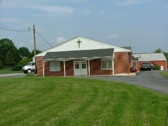
Property Record
1750 Appleton Rd, Elkton, MD 21921


Save to a Folder
{{folder.Name}}
{{folder.ListingIds.length}} Properties
{{folder.ListingIds.length}} Property
Create a New Folder
Property Detail
1750 Appleton Rd
04-011465
3.106 ACRES 1750 APPLETON ROAD S OF COWENTOWN
Storebuilding
Cecil
BG
Maryland
B and X Area of moderate flood hazard, usually the area between the limits of the 100-year and 500-year floods.
3.11 AC
2025
Cecil County
2025
Baltimore
030602
Philadelphia-Camden-Wilmington, PA-NJ-DE-MD
1,688 SF
NEARBY LISTINGS FOR SALE OR LEASE
-
-
View all Elkton listings for sale on LoopNet.com
DEMOGRAPHICS near 1750 Appleton Rd
1 mile
3 mile
5 mile
2025 Total Population
383
27,649
87,487
2030 Population
393
28,683
91,532
Pop Growth 2025-2030
+ 2.61%
+ 3.74%
+ 4.62%
Average Age
40
40
37
2025 Total Households
148
11,021
31,387
HH Growth 2025-2030
+ 2.70%
+ 3.88%
+ 4.81%
Median Household Inc
$91,477
$93,896
$81,500
Avg Household Size
2.50
2.50
2.50
2025 Avg HH Vehicles
2.00
2.00
2.00
Median Home Value
$294,285
$371,144
$356,703
Median Year Built
1981
1978
1983
Nearby Places
Map Layers
Map Styles
 Street
 Aerial
Layers
 Traffic
 Biking
Places
Listings with unknown addresses are not visible on the map
- Restaurants
- Banks
- Shops
- Fitness
- Groceries
PUBLIC TRANSPORTATION
COMMUTER RAIL
Newark (R2 - Southeastern Pennsylvania Transportation Authority Regional Rail (SEPTA Regional Rail))
Drive
Walk
Distance
Newark (R2 - Southeastern Pennsylvania Transportation Authority Regional Rail (SEPTA Regional Rail))
9 min
4.9 mi
Freight Ports
Port of Wilmington, RI
Drive
Walk
Distance
Port of Wilmington, RI
29 min
20.3 mi
Nearby Properties
Address
Land Use
TOTAL SIZE
Lot Size
Zoning
Address
Land Use
TOTAL SIZE
Lot Size
Zoning
383,319 SF
234.70 AC
I
Address
Land Use
TOTAL SIZE
Lot Size
Zoning
756,122 SF
70.18 AC
M1
Address
Land Use
TOTAL SIZE
Lot Size
Zoning
15,374 SF
15.37 AC
18RH
Address
Land Use
TOTAL SIZE
Lot Size
Zoning
142,774 SF
131.33 AC
M1
Address
Land Use
TOTAL SIZE
Lot Size
Zoning
70,092 SF
41.59 AC
UR
Address
Land Use
TOTAL SIZE
Lot Size
Zoning
19.26 AC
RM
Address
Land Use
TOTAL SIZE
Lot Size
Zoning
64,148 SF
31.54 AC
M1
Address
Land Use
TOTAL SIZE
Lot Size
Zoning
108,553 SF
5.89 AC
18RM
Address
Land Use
TOTAL SIZE
Lot Size
Zoning
10,253 SF
8.70 AC
18RM
Address
Land Use
TOTAL SIZE
Lot Size
Zoning
20,973 SF
75.14 AC
M1
Address
Land Use
TOTAL SIZE
Lot Size
Zoning
294,288 SF
22.25 AC
NCAP
Address
Land Use
TOTAL SIZE
Lot Size
Zoning
81,072 SF
12.86 AC
RM
Address
Land Use
TOTAL SIZE
Lot Size
Zoning
15,215 SF
20.22 AC
18RH
Address
Land Use
TOTAL SIZE
Lot Size
Zoning
124,986 SF
12.40 AC
18MI
Address
Land Use
TOTAL SIZE
Lot Size
Zoning
41,000 SF
32.49 AC
M1
Address
Land Use
TOTAL SIZE
Lot Size
Zoning
10,512 SF
119.43 AC
18RS
Address
Land Use
TOTAL SIZE
Lot Size
Zoning
72,725 SF
18.48 AC
18OFD
Address
Land Use
TOTAL SIZE
Lot Size
Zoning
12,332 SF
4,237.74 AC
OS
Address
Land Use
TOTAL SIZE
Lot Size
Zoning
284,739 SF
9.55 AC
18RM
Address
Land Use
TOTAL SIZE
Lot Size
Zoning
204,930 SF
9.38 AC
NCAP
Address
Land Use
TOTAL SIZE
Lot Size
Zoning
1,828 SF
10.37 AC
18RM
Address
Land Use
TOTAL SIZE
Lot Size
Zoning
91,879 SF
19.57 AC
18BC
Address
Land Use
TOTAL SIZE
Lot Size
Zoning
44,705 SF
6.95 AC
18AC
Address
Land Use
TOTAL SIZE
Lot Size
Zoning
131,806 SF
21.97 AC
BI
Address
Land Use
TOTAL SIZE
Lot Size
Zoning
80,048 SF
1.71 AC
18BB
Address
Land Use
TOTAL SIZE
Lot Size
Zoning
306,221 SF
17.44 AC
18OFD
Address
Land Use
TOTAL SIZE
Lot Size
Zoning
40,074 SF
90.98 AC
M1
Address
Land Use
TOTAL SIZE
Lot Size
Zoning
114,452 SF
13.07 AC
18BC
Address
Land Use
TOTAL SIZE
Lot Size
Zoning
35,220 SF
3.36 AC
18BB
Address
Land Use
TOTAL SIZE
Lot Size
Zoning
113,237 SF
5.20 AC
18RM
The World's #1 Commercial Real Estate Marketplace
Connect with us
© 2026 CoStar Group
The information above has been obtained from sources believed reliable. While we do not doubt its accuracy we have not verified it and make no guarantee, warranty or representation about it. It is your responsibility to independently confirm its accuracy and completeness. Any projections, opinions, assumptions, or estimates used are for example only and do not represent the current or future performance of the property. The value of this transaction to you depends on tax and other factors which should be evaluated by your tax, financial, and legal advisors. You and your advisors should conduct a careful, independent investigation of the property to determine to your satisfaction the suitability of the property for your needs.