Property Record
1750 Bobs Hollow Ln, Dupont, WA 98327
NEARBY LISTINGS FOR SALE OR LEASE
-
-
View all Dupont listings for sale on LoopNet.com
Property Detail
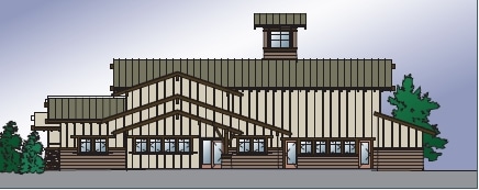
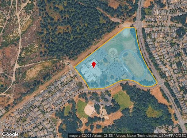
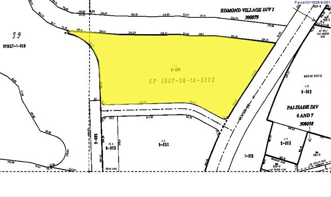
1750 Bobs Hollow Ln
011926-3011
Oaks
Publicschool
TRACT B VILLAGE II DIVISION8
X
Pierce
53053C0507E
Washington
2024
20 AC
2025
Dupont
072802
Seattle/Puget Sound
160,000 SF
Seattle-Tacoma-Bellevue, WA
DEMOGRAPHICS near 1750 Bobs Hollow Ln
1 Mile
3 Mile
5 Mile
2024 Total Population
5,787
19,792
43,436
2029 Population
5,892
20,352
45,208
Pop Growth 2024-2029
+ 1.81%
+ 2.83%
+ 4.08%
Average Age
35
29
32
2024 Total Households
2,273
5,447
13,345
HH Growth 2024-2029
+ 1.80%
+ 2.94%
+ 4.38%
Median Household Inc
$95,975
$84,478
$77,816
Avg Household Size
2.50
2.90
2.90
2024 Avg HH Vehicles
2.00
2.00
2.00
Median Home Value
$463,843
$463,790
$491,733
Median Year Built
2000
1998
1995
Nearby Places
- Restaurants
- Banks
- Shops
- Fitness
- Groceries
PUBLIC TRANSPORTATION
COMMUTER RAIL
Lakewood Station (Seattle - Tacoma/Lakewood - Sound Transit)
DRIVE
WALK
Distance
Lakewood Station (Seattle - Tacoma/Lakewood - Sound Transit)
15 min
9.9 mi
AIRPORT
Seattle-Tacoma International
DRIVE
WALK
Distance
Seattle-Tacoma International
55 min
38.1 mi
Freight Ports
Port of Tacoma
DRIVE
WALK
Distance
Port of Tacoma
28 min
19.7 mi
Nearby Properties
Address
Land Use
TOTAL SIZE
Lot Size
Zoning
Address
Land Use
TOTAL SIZE
Lot Size
Zoning
1,032,940 SF
84.10 AC
MRP
Address
Land Use
TOTAL SIZE
Lot Size
Zoning
746,520 SF
42.97 AC
Address
Land Use
TOTAL SIZE
Lot Size
Zoning
625,412 SF
37.50 AC
IND
Address
Land Use
TOTAL SIZE
Lot Size
Zoning
484,389 SF
26.09 AC
Address
Land Use
TOTAL SIZE
Lot Size
Zoning
205,592 SF
4.37 AC
MXD
Address
Land Use
TOTAL SIZE
Lot Size
Zoning
168,617 SF
10.99 AC
Address
Land Use
TOTAL SIZE
Lot Size
Zoning
451,151 SF
19.33 AC
IND
Address
Land Use
TOTAL SIZE
Lot Size
Zoning
337,600 SF
19.21 AC
Address
Land Use
TOTAL SIZE
Lot Size
Zoning
1 SF
52.10 AC
IND
Address
Land Use
TOTAL SIZE
Lot Size
Zoning
300,608 SF
13.57 AC
IND
Address
Land Use
TOTAL SIZE
Lot Size
Zoning
121,600 SF
5.92 AC
MXD
Address
Land Use
TOTAL SIZE
Lot Size
Zoning
355,074 SF
51.63 AC
OFF
Address
Land Use
TOTAL SIZE
Lot Size
Zoning
284.80 AC
MIL
Address
Land Use
TOTAL SIZE
Lot Size
Zoning
225,300 SF
13.51 AC
Address
Land Use
TOTAL SIZE
Lot Size
Zoning
157,421 SF
6.23 AC
R-5
Address
Land Use
TOTAL SIZE
Lot Size
Zoning
91,580 SF
2.51 AC
DUP
Address
Land Use
TOTAL SIZE
Lot Size
Zoning
144,304 SF
13.51 AC
IND
Address
Land Use
TOTAL SIZE
Lot Size
Zoning
31,723 SF
10.01 AC
R-5
Address
Land Use
TOTAL SIZE
Lot Size
Zoning
26,362 SF
7.70 AC
MXD
Address
Land Use
TOTAL SIZE
Lot Size
Zoning
75,910 SF
2.11 AC
COM
Address
Land Use
TOTAL SIZE
Lot Size
Zoning
53,520 SF
2.87 AC
MXD
Address
Land Use
TOTAL SIZE
Lot Size
Zoning
49,580 SF
2.41 AC
DUP
Address
Land Use
TOTAL SIZE
Lot Size
Zoning
23.90 AC
CP
Address
Land Use
TOTAL SIZE
Lot Size
Zoning
38,273 SF
2.92 AC
MXD
Address
Land Use
TOTAL SIZE
Lot Size
Zoning
49,731 SF
1.46 AC
MXD
Address
Land Use
TOTAL SIZE
Lot Size
Zoning
87,864 SF
1.13 AC
Address
Land Use
TOTAL SIZE
Lot Size
Zoning
57,970 SF
6.90 AC
IND
Address
Land Use
TOTAL SIZE
Lot Size
Zoning
19,902 SF
1.84 AC
MRP
Address
Land Use
TOTAL SIZE
Lot Size
Zoning
17.72 AC
The World's #1 Commercial Real Estate Marketplace
Connect with us
© 2025 CoStar Group
The information above has been obtained from sources believed reliable. While we do not doubt its accuracy we have not verified it and make no guarantee, warranty or representation about it. It is your responsibility to independently confirm its accuracy and completeness. Any projections, opinions, assumptions, or estimates used are for example only and do not represent the current or future performance of the property. The value of this transaction to you depends on tax and other factors which should be evaluated by your tax, financial, and legal advisors. You and your advisors should conduct a careful, independent investigation of the property to determine to your satisfaction the suitability of the property for your needs.