Property Record
1750 Granite Station Rd, Gettysburg, PA 17325
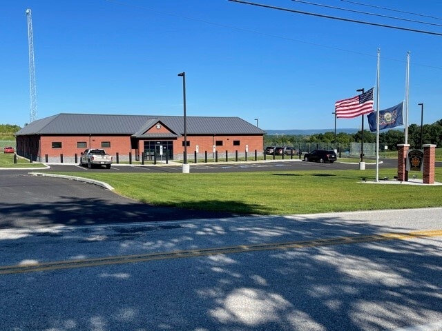
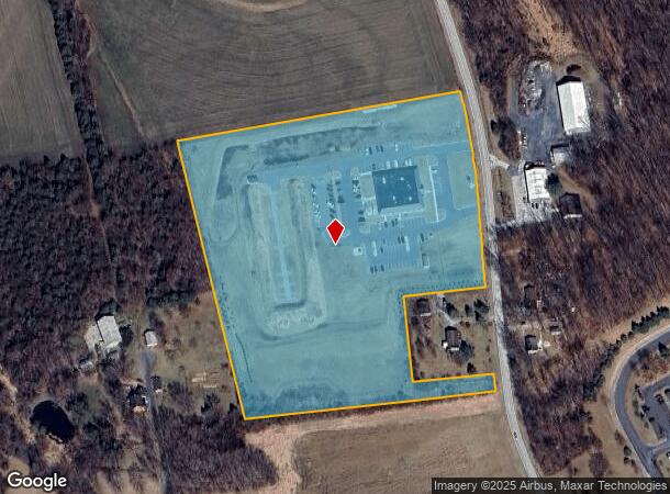
This Property Is For Sale
NEARBY LISTINGS FOR SALE OR LEASE
-
-
View all Gettysburg listings for sale on LoopNet.com
Property Detail
1750 Granite Station Rd
38 H11-0036H--000
Adams
Officebuilding
Pennsylvania
X
l-0001
42001C0256E
13.02 AC
2025
Adams County
2025
Philadelphia
030600
Gettysburg, PA
DEMOGRAPHICS near 1750 Granite Station Rd
1 Mile
3 Mile
5 Mile
2024 Total Population
451
4,816
24,768
2029 Population
474
5,032
25,259
Pop Growth 2024-2029
+ 5.10%
+ 4.49%
+ 1.98%
Average Age
47
46
41
2024 Total Households
163
1,743
8,702
HH Growth 2024-2029
+ 4.91%
+ 4.42%
+ 2.13%
Median Household Inc
$67,500
$65,214
$67,933
Avg Household Size
2.40
2.40
2.30
2024 Avg HH Vehicles
2.00
2.00
2.00
Median Home Value
$264,285
$259,056
$251,606
Median Year Built
1985
1984
1972
Nearby Places
Map Layers
Map Styles
 Street
 Aerial
- Restaurants
- Banks
- Shops
- Fitness
- Groceries
Nearby Properties
Address
Land Use
TOTAL SIZE
Lot Size
Zoning
Address
Land Use
TOTAL SIZE
Lot Size
Zoning
298.91 AC
EC2
Address
Land Use
TOTAL SIZE
Lot Size
Zoning
13.12 AC
EC1
Address
Land Use
TOTAL SIZE
Lot Size
Zoning
7.27 AC
EC1
Address
Land Use
TOTAL SIZE
Lot Size
Zoning
13.09 AC
EC1
Address
Land Use
TOTAL SIZE
Lot Size
Zoning
22.85 AC
EC1
Address
Land Use
TOTAL SIZE
Lot Size
Zoning
3.18 AC
EC1
Address
Land Use
TOTAL SIZE
Lot Size
Zoning
74.36 AC
EC1
Address
Land Use
TOTAL SIZE
Lot Size
Zoning
Address
Land Use
TOTAL SIZE
Lot Size
Zoning
8.02 AC
EC1
Address
Land Use
TOTAL SIZE
Lot Size
Zoning
Address
Land Use
TOTAL SIZE
Lot Size
Zoning
17.32 AC
R1
Address
Land Use
TOTAL SIZE
Lot Size
Zoning
Address
Land Use
TOTAL SIZE
Lot Size
Zoning
Address
Land Use
TOTAL SIZE
Lot Size
Zoning
89.42 AC
RR
Address
Land Use
TOTAL SIZE
Lot Size
Zoning
13.25 AC
EC1
Address
Land Use
TOTAL SIZE
Lot Size
Zoning
2.90 AC
EC1
Address
Land Use
TOTAL SIZE
Lot Size
Zoning
6.60 AC
EC1
Address
Land Use
TOTAL SIZE
Lot Size
Zoning
5.61 AC
EC1
Address
Land Use
TOTAL SIZE
Lot Size
Zoning
3.53 AC
EC1
Address
Land Use
TOTAL SIZE
Lot Size
Zoning
180.25 AC
EC2
Address
Land Use
TOTAL SIZE
Lot Size
Zoning
9.93 AC
EC1
Address
Land Use
TOTAL SIZE
Lot Size
Zoning
103.17 AC
RR
Address
Land Use
TOTAL SIZE
Lot Size
Zoning
17.24 AC
EC1
Address
Land Use
TOTAL SIZE
Lot Size
Zoning
6.99 AC
EC1
Address
Land Use
TOTAL SIZE
Lot Size
Zoning
60.73 AC
EC1
Address
Land Use
TOTAL SIZE
Lot Size
Zoning
7.86 AC
EC1
Address
Land Use
TOTAL SIZE
Lot Size
Zoning
6.19 AC
Address
Land Use
TOTAL SIZE
Lot Size
Zoning
Address
Land Use
TOTAL SIZE
Lot Size
Zoning
36.34 AC
EC1
Address
Land Use
TOTAL SIZE
Lot Size
Zoning
3.38 AC
The World's #1 Commercial Real Estate Marketplace
Connect with us
© 2026 CoStar Group
The information above has been obtained from sources believed reliable. While we do not doubt its accuracy we have not verified it and make no guarantee, warranty or representation about it. It is your responsibility to independently confirm its accuracy and completeness. Any projections, opinions, assumptions, or estimates used are for example only and do not represent the current or future performance of the property. The value of this transaction to you depends on tax and other factors which should be evaluated by your tax, financial, and legal advisors. You and your advisors should conduct a careful, independent investigation of the property to determine to your satisfaction the suitability of the property for your needs.