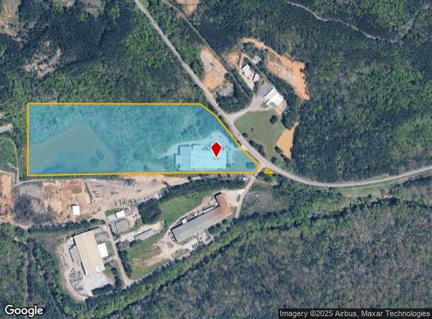
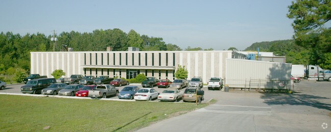
Property Record
1750 Highway 150, Bessemer, AL 35022

NEARBY LISTINGS FOR SALE OR LEASE
Property Detail
1750 Highway 150
38-00-24-4-002-002.000
POB 665 FT S OF NW COR OF SE 1/4 SEC 24 T 19 S R 4 W TH CON S 650 FT E 2295 FT TO R/W OF ALA HWY #150 TH NW ALG R/W 875 FT W 1700 FT TO POB LESS & EXC RD R/W
Warehouse
Jefferson
X
Alabama
01117C0185F
29 AC
2023
Bessemer
2024
Birmingham
014303
Birmingham-Hoover, AL
74,686 SF
DEMOGRAPHICS near 1750 Highway 150
1 Mile
3 Mile
5 Mile
2024 Total Population
706
22,224
75,429
2029 Population
709
21,510
74,413
Pop Growth 2024-2029
+ 0.42%
(3.21%)
(1.35%)
Average Age
38
39
40
2024 Total Households
211
8,127
28,935
HH Growth 2024-2029
+ 0.47%
(3.29%)
(1.50%)
Median Household Inc
$148,213
$102,363
$75,052
Avg Household Size
3.00
2.70
2.50
2024 Avg HH Vehicles
2.00
2.00
2.00
Median Home Value
$414,197
$335,795
$291,274
Median Year Built
2010
2000
1988
Nearby Places
Map Layers
Map Styles
 Street
 Aerial
- Restaurants
- Banks
- Shops
- Fitness
- Groceries
PUBLIC TRANSPORTATION
AIRPORT
Birmingham-Shuttlesworth International
DRIVE
WALK
Distance
Birmingham-Shuttlesworth International
35 min
23.3 mi
Freight Ports
Port of Mobile
DRIVE
WALK
Distance
Port of Mobile
279 min
254.0 mi
Nearby Properties
Address
Land Use
TOTAL SIZE
Lot Size
Zoning
Address
Land Use
TOTAL SIZE
Lot Size
Zoning
143,148 SF
15.60 AC
CP
Address
Land Use
TOTAL SIZE
Lot Size
Zoning
106 AC
I3
Address
Land Use
TOTAL SIZE
Lot Size
Zoning
929,435 SF
58 AC
I4
Address
Land Use
TOTAL SIZE
Lot Size
Zoning
75,840 SF
20.10 AC
I3
Address
Land Use
TOTAL SIZE
Lot Size
Zoning
197,717 SF
19.02 AC
PUD
Address
Land Use
TOTAL SIZE
Lot Size
Zoning
224,184 SF
65.60 AC
I3
Address
Land Use
TOTAL SIZE
Lot Size
Zoning
149,299 SF
15.70 AC
PUD
Address
Land Use
TOTAL SIZE
Lot Size
Zoning
210,815 SF
114 AC
I1-A
Address
Land Use
TOTAL SIZE
Lot Size
Zoning
231,385 SF
50.40 AC
R6
Address
Land Use
TOTAL SIZE
Lot Size
Zoning
118,309 SF
88.50 AC
I3
Address
Land Use
TOTAL SIZE
Lot Size
Zoning
113,220 SF
22.60 AC
I3
Address
Land Use
TOTAL SIZE
Lot Size
Zoning
185,856 SF
6.70 AC
PC
Address
Land Use
TOTAL SIZE
Lot Size
Zoning
105,299 SF
25.50 AC
T3
Address
Land Use
TOTAL SIZE
Lot Size
Zoning
187,200 SF
22 AC
I3
Address
Land Use
TOTAL SIZE
Lot Size
Zoning
83,700 SF
60 AC
PC
Address
Land Use
TOTAL SIZE
Lot Size
Zoning
440,970 SF
16 AC
I2
Address
Land Use
TOTAL SIZE
Lot Size
Zoning
208,000 SF
9.60 AC
SC-1
Address
Land Use
TOTAL SIZE
Lot Size
Zoning
23,493 SF
2.85 AC
C1
Address
Land Use
TOTAL SIZE
Lot Size
Zoning
130,568 SF
8.52 AC
SC-1
Address
Land Use
TOTAL SIZE
Lot Size
Zoning
88.50 AC
I3
Address
Land Use
TOTAL SIZE
Lot Size
Zoning
92,390 SF
3.30 AC
C2
Address
Land Use
TOTAL SIZE
Lot Size
Zoning
87,429 SF
6.80 AC
PC
Address
Land Use
TOTAL SIZE
Lot Size
Zoning
118,676 SF
4.09 AC
I2
Address
Land Use
TOTAL SIZE
Lot Size
Zoning
33,964 SF
5.80 AC
C1
Address
Land Use
TOTAL SIZE
Lot Size
Zoning
123,814 SF
10.15 AC
I2
Address
Land Use
TOTAL SIZE
Lot Size
Zoning
36,528 SF
4.20 AC
PUD
Address
Land Use
TOTAL SIZE
Lot Size
Zoning
51,119 SF
9.90 AC
PC
Address
Land Use
TOTAL SIZE
Lot Size
Zoning
72,745 SF
8.90 AC
SC-1
Address
Land Use
TOTAL SIZE
Lot Size
Zoning
26,234 SF
0.60 AC
CP
Address
Land Use
TOTAL SIZE
Lot Size
Zoning
27,760 SF
7 AC
PC
The World's #1 Commercial Real Estate Marketplace
Connect with us
© 2025 CoStar Group
The information above has been obtained from sources believed reliable. While we do not doubt its accuracy we have not verified it and make no guarantee, warranty or representation about it. It is your responsibility to independently confirm its accuracy and completeness. Any projections, opinions, assumptions, or estimates used are for example only and do not represent the current or future performance of the property. The value of this transaction to you depends on tax and other factors which should be evaluated by your tax, financial, and legal advisors. You and your advisors should conduct a careful, independent investigation of the property to determine to your satisfaction the suitability of the property for your needs.