Property Record
1750 Military Rd, Buffalo, NY 14217
NEARBY LISTINGS FOR SALE OR LEASE
Property Detail
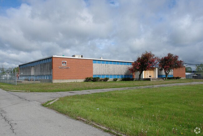
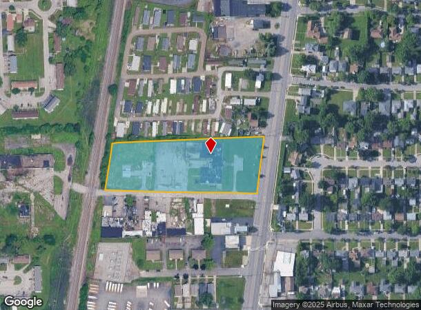
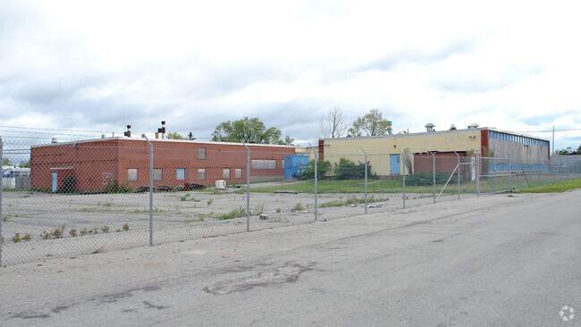
1750 Military Rd
Buffalo-Cheektowaga-Niagara Falls, NY
Holland Land Companys Survey
146489-065-280-0001-003-000
N:LUCIDOL 2.705 AC W:P C RR S:ROADWAY 241.9 X 633
Officebuilding
Erie
X
New York
36029C0182H
3.000
2025
2.71 AC
2024
North
008700
Buffalo/Niagara Falls
17,480 SF
DEMOGRAPHICS near 1750 Military Rd
1 Mile
3 Mile
5 Mile
2024 Total Population
10,824
107,786
265,638
2029 Population
10,728
105,886
261,279
Pop Growth 2024-2029
(0.89%)
(1.76%)
(1.64%)
Average Age
42
41
39
2024 Total Households
4,937
48,820
113,379
HH Growth 2024-2029
(1.07%)
(1.80%)
(1.73%)
Median Household Inc
$52,149
$60,399
$59,156
Avg Household Size
2.10
2.10
2.20
2024 Avg HH Vehicles
1.00
1.00
1.00
Median Home Value
$151,909
$163,226
$175,140
Median Year Built
1953
1950
1949
Nearby Places
- Restaurants
- Banks
- Shops
- Fitness
- Groceries
PUBLIC TRANSPORTATION
AIRPORT
Niagara Falls International
DRIVE
WALK
Distance
Niagara Falls International
19 min
9.9 mi
Buffalo Niagara International
DRIVE
WALK
Distance
Buffalo Niagara International
20 min
11.5 mi
Freight Ports
Port of Toledo
DRIVE
WALK
Distance
Port of Toledo
372 min
312.8 mi
SALE & LEASE HISTORY
LISTING DATE
SALE/LEASE

Sep 23, 2016
For Sale
Nearby Properties
Address
Land Use
TOTAL SIZE
Lot Size
Zoning
Address
Land Use
TOTAL SIZE
Lot Size
Zoning
139,224 SF
13.72 AC
WID
Address
Land Use
TOTAL SIZE
Lot Size
Zoning
80,927 SF
28.20 AC
WID
Address
Land Use
TOTAL SIZE
Lot Size
Zoning
239,735 SF
17.73 AC
TND
Address
Land Use
TOTAL SIZE
Lot Size
Zoning
650,000 SF
42.15 AC
G-1
Address
Land Use
TOTAL SIZE
Lot Size
Zoning
67,666 SF
17.43 AC
G-1
Address
Land Use
TOTAL SIZE
Lot Size
Zoning
3.20 AC
G-1
Address
Land Use
TOTAL SIZE
Lot Size
Zoning
11,808 SF
11.93 AC
N-3R
Address
Land Use
TOTAL SIZE
Lot Size
Zoning
2,474 SF
24.84 AC
Address
Land Use
TOTAL SIZE
Lot Size
Zoning
67,000 SF
6.50 AC
Address
Land Use
TOTAL SIZE
Lot Size
Zoning
120,954 SF
9.74 AC
D-S
Address
Land Use
TOTAL SIZE
Lot Size
Zoning
356,891 SF
21.33 AC
B
Address
Land Use
TOTAL SIZE
Lot Size
Zoning
16 AC
G-1
Address
Land Use
TOTAL SIZE
Lot Size
Zoning
151,641 SF
1.53 AC
N-1S
Address
Land Use
TOTAL SIZE
Lot Size
Zoning
107,490 SF
3.55 AC
Address
Land Use
TOTAL SIZE
Lot Size
Zoning
81,224 SF
0.45 AC
Address
Land Use
TOTAL SIZE
Lot Size
Zoning
33,970 SF
9.70 AC
Address
Land Use
TOTAL SIZE
Lot Size
Zoning
135,140 SF
25.60 AC
Address
Land Use
TOTAL SIZE
Lot Size
Zoning
138,000 SF
7.30 AC
P-S
Address
Land Use
TOTAL SIZE
Lot Size
Zoning
Address
Land Use
TOTAL SIZE
Lot Size
Zoning
3,840 SF
11.80 AC
D-R
Address
Land Use
TOTAL SIZE
Lot Size
Zoning
13,836 SF
7.70 AC
D-R
Address
Land Use
TOTAL SIZE
Lot Size
Zoning
265,850 SF
19.35 AC
Address
Land Use
TOTAL SIZE
Lot Size
Zoning
Address
Land Use
TOTAL SIZE
Lot Size
Zoning
Address
Land Use
TOTAL SIZE
Lot Size
Zoning
260,199 SF
16.25 AC
Address
Land Use
TOTAL SIZE
Lot Size
Zoning
122,248 SF
9.15 AC
D-S
Address
Land Use
TOTAL SIZE
Lot Size
Zoning
2,797 SF
0.16 AC
N-1S
Address
Land Use
TOTAL SIZE
Lot Size
Zoning
3,862 SF
11 AC
A
Address
Land Use
TOTAL SIZE
Lot Size
Zoning
4,384 SF
6.20 AC
D-R
Address
Land Use
TOTAL SIZE
Lot Size
Zoning
86,974 SF
2.57 AC
N-1S
The World's #1 Commercial Real Estate Marketplace
Connect with us
© 2025 CoStar Group
The information above has been obtained from sources believed reliable. While we do not doubt its accuracy we have not verified it and make no guarantee, warranty or representation about it. It is your responsibility to independently confirm its accuracy and completeness. Any projections, opinions, assumptions, or estimates used are for example only and do not represent the current or future performance of the property. The value of this transaction to you depends on tax and other factors which should be evaluated by your tax, financial, and legal advisors. You and your advisors should conduct a careful, independent investigation of the property to determine to your satisfaction the suitability of the property for your needs.