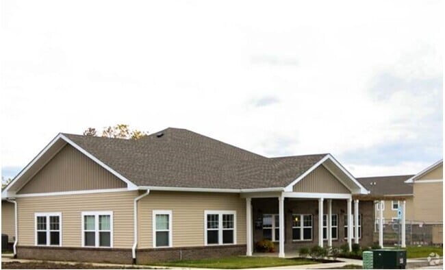
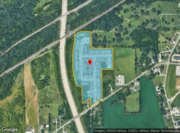
Property Record
1750 Paige Rd, Lafayette, IN 47909
NEARBY LISTINGS FOR SALE OR LEASE
Property Detail
1750 Paige Rd
Lafayette-West Lafayette, IN
Overlook Pointe Apartments Final Plat Be
79-07-31-326-013.000-005
OVERLOOK POINTE APARTMENTS LOT 1
Apartment
Tippecanoe
X
Indiana
18157C0143E
1
2024
17.89 AC
2024
Lafayette/Kokomo
001603
Other Market Areas
286,889 SF
DEMOGRAPHICS near 1750 Paige Rd
1 Mile
3 Mile
5 Mile
2024 Total Population
3,181
65,891
128,029
2029 Population
3,304
68,337
132,161
Pop Growth 2024-2029
+ 3.87%
+ 3.71%
+ 3.23%
Average Age
34
33
34
2024 Total Households
1,439
26,816
51,475
HH Growth 2024-2029
+ 3.96%
+ 4.19%
+ 3.59%
Median Household Inc
$37,570
$39,068
$46,315
Avg Household Size
2.20
2.10
2.20
2024 Avg HH Vehicles
1.00
2.00
2.00
Median Home Value
$162,692
$156,463
$172,513
Median Year Built
1990
1978
1981
Nearby Places
- Restaurants
- Banks
- Shops
- Fitness
- Groceries
PUBLIC TRANSPORTATION
COMMUTER RAIL
Lafayette Amtrak Station (Cardinal - Amtrak)
DRIVE
WALK
Distance
Lafayette Amtrak Station (Cardinal - Amtrak)
8 min
3.3 mi
Freight Ports
Port Milwaukee
DRIVE
WALK
Distance
Port Milwaukee
258 min
210.7 mi
Nearby Properties
Address
Land Use
TOTAL SIZE
Lot Size
Zoning
Address
Land Use
TOTAL SIZE
Lot Size
Zoning
469,872 SF
0.85 AC
Address
Land Use
TOTAL SIZE
Lot Size
Zoning
377,937 SF
4.80 AC
Address
Land Use
TOTAL SIZE
Lot Size
Zoning
385,162 SF
1 AC
Address
Land Use
TOTAL SIZE
Lot Size
Zoning
401,345 SF
1.64 AC
Address
Land Use
TOTAL SIZE
Lot Size
Zoning
498,665 SF
1.94 AC
Address
Land Use
TOTAL SIZE
Lot Size
Zoning
Address
Land Use
TOTAL SIZE
Lot Size
Zoning
417,720 SF
3.09 AC
Address
Land Use
TOTAL SIZE
Lot Size
Zoning
249,214 SF
1.93 AC
Address
Land Use
TOTAL SIZE
Lot Size
Zoning
159,723 SF
44 SF
Address
Land Use
TOTAL SIZE
Lot Size
Zoning
148,860 SF
1.25 AC
Address
Land Use
TOTAL SIZE
Lot Size
Zoning
0.01 AC
Address
Land Use
TOTAL SIZE
Lot Size
Zoning
232,565 SF
1.15 AC
Address
Land Use
TOTAL SIZE
Lot Size
Zoning
8,675 SF
0.02 AC
Address
Land Use
TOTAL SIZE
Lot Size
Zoning
205,701 SF
1.27 AC
Address
Land Use
TOTAL SIZE
Lot Size
Zoning
27,300 SF
22.52 AC
Address
Land Use
TOTAL SIZE
Lot Size
Zoning
164,234 SF
0.88 AC
Address
Land Use
TOTAL SIZE
Lot Size
Zoning
184,441 SF
44 SF
Address
Land Use
TOTAL SIZE
Lot Size
Zoning
222,276 SF
0.31 AC
Address
Land Use
TOTAL SIZE
Lot Size
Zoning
203,830 SF
18.73 AC
Address
Land Use
TOTAL SIZE
Lot Size
Zoning
267,379 SF
87 SF
Address
Land Use
TOTAL SIZE
Lot Size
Zoning
113,044 SF
44 SF
Address
Land Use
TOTAL SIZE
Lot Size
Zoning
141,960 SF
2.27 AC
Address
Land Use
TOTAL SIZE
Lot Size
Zoning
118,066 SF
0.80 AC
Address
Land Use
TOTAL SIZE
Lot Size
Zoning
135,090 SF
0.80 AC
Address
Land Use
TOTAL SIZE
Lot Size
Zoning
111,600 SF
87 SF
Address
Land Use
TOTAL SIZE
Lot Size
Zoning
109,515 SF
0.85 AC
Address
Land Use
TOTAL SIZE
Lot Size
Zoning
72,739 SF
1.46 AC
Address
Land Use
TOTAL SIZE
Lot Size
Zoning
109,876 SF
0.61 AC
The World's #1 Commercial Real Estate Marketplace
Connect with us
© 2025 CoStar Group
The information above has been obtained from sources believed reliable. While we do not doubt its accuracy we have not verified it and make no guarantee, warranty or representation about it. It is your responsibility to independently confirm its accuracy and completeness. Any projections, opinions, assumptions, or estimates used are for example only and do not represent the current or future performance of the property. The value of this transaction to you depends on tax and other factors which should be evaluated by your tax, financial, and legal advisors. You and your advisors should conduct a careful, independent investigation of the property to determine to your satisfaction the suitability of the property for your needs.