Property Record
1750 Route 211 E, Middletown, NY 10941
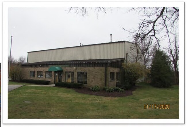

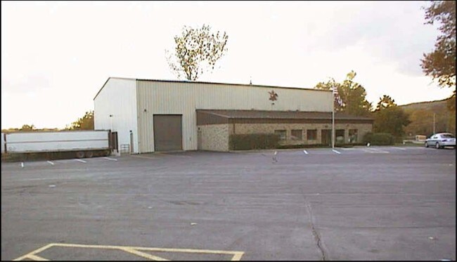

Property Detail
1750 Route 211 E
335200-031-000-0001-085.000-0000
LT 2 ROWLEY DEVELOPMENT MAP 633-04
Warehouse
Orange
RA-1
New York
B and X Area of moderate flood hazard, usually the area between the limits of the 100-year and 500-year floods.
85.00
2024
3 AC
2024
Orange County
955400
Northern New Jersey
9,824 SF
Kiryas Joel-Poughkeepsie-Newburgh, NY
NEARBY LISTINGS FOR SALE OR LEASE
DEMOGRAPHICS near 1750 Route 211 E
1 mile
3 mile
5 mile
2025 Total Population
554
6,957
32,406
2030 Population
582
7,150
33,035
Pop Growth 2025-2030
+ 5.05%
+ 2.77%
+ 1.94%
Average Age
43
40
41
2025 Total Households
195
2,526
11,786
HH Growth 2025-2030
+ 6.15%
+ 2.97%
+ 2.03%
Median Household Inc
$83,000
$92,045
$100,222
Avg Household Size
2.60
2.70
2.70
2025 Avg HH Vehicles
2.00
2.00
2.00
Median Home Value
$295,832
$394,867
$392,486
Median Year Built
1985
1980
1980
Nearby Places
Map Layers
Map Styles
 Street
 Aerial
Transit
 Traffic
 Biking
Places
Listings with unknown addresses are not visible on the map
- Restaurants
- Banks
- Shops
- Fitness
- Groceries
PUBLIC TRANSPORTATION
COMMUTER RAIL
Campbell Hall (Bergen County/Port Jervis Line - NJ Transit Commuter Rail (NJ Transit), Main/Port Jervis Line - NJ Transit Commuter Rail (NJ Transit))
Drive
Walk
Distance
Campbell Hall (Bergen County/Port Jervis Line - NJ Transit Commuter Rail (NJ Transit), Main/Port Jervis Line - NJ Transit Commuter Rail (NJ Transit))
11 min
4.3 mi
Middletown New York (Bergen County/Port Jervis Line - NJ Transit Commuter Rail (NJ Transit), Main/Port Jervis Line - NJ Transit Commuter Rail (NJ Transit))
Drive
Walk
Distance
Middletown New York (Bergen County/Port Jervis Line - NJ Transit Commuter Rail (NJ Transit), Main/Port Jervis Line - NJ Transit Commuter Rail (NJ Transit))
10 min
4.9 mi
AIRPORT
New York Stewart International
Drive
Walk
Distance
New York Stewart International
24 min
14.2 mi
Freight Ports
Port Newark Container Terminal
Drive
Walk
Distance
Port Newark Container Terminal
98 min
73.9 mi
SALE & LEASE HISTORY
LISTING DATE
SALE/LEASE

Nov 20, 2020
For Sale
May 24, 2021
For Lease
Nearby Properties
Address
Land Use
TOTAL SIZE
Lot Size
Zoning
Address
Land Use
TOTAL SIZE
Lot Size
Zoning
340,782 SF
37 AC
LUI
Address
Land Use
TOTAL SIZE
Lot Size
Zoning
374,356 SF
35.90 AC
LUI
Address
Land Use
TOTAL SIZE
Lot Size
Zoning
25,800 SF
80.20 AC
LUI
Address
Land Use
TOTAL SIZE
Lot Size
Zoning
366,680 SF
32.10 AC
Address
Land Use
TOTAL SIZE
Lot Size
Zoning
58.10 AC
R1
Address
Land Use
TOTAL SIZE
Lot Size
Zoning
330.10 AC
R4A*
Address
Land Use
TOTAL SIZE
Lot Size
Zoning
4,022 SF
360.50 AC
R4A*
Address
Land Use
TOTAL SIZE
Lot Size
Zoning
41.40 AC
R4A
Address
Land Use
TOTAL SIZE
Lot Size
Zoning
55,200 SF
11.80 AC
R3A*
Address
Land Use
TOTAL SIZE
Lot Size
Zoning
430,275 SF
35.60 AC
O/R
Address
Land Use
TOTAL SIZE
Lot Size
Zoning
10 AC
HRC4*
Address
Land Use
TOTAL SIZE
Lot Size
Zoning
1,240 SF
188 AC
R4A*
Address
Land Use
TOTAL SIZE
Lot Size
Zoning
6,910 SF
186.70 AC
R4A
Address
Land Use
TOTAL SIZE
Lot Size
Zoning
90,708 SF
9.50 AC
R1
Address
Land Use
TOTAL SIZE
Lot Size
Zoning
7,948 SF
115 AC
R4A
Address
Land Use
TOTAL SIZE
Lot Size
Zoning
90,708 SF
3.30 AC
R1
Address
Land Use
TOTAL SIZE
Lot Size
Zoning
90,708 SF
3.30 AC
R1
Address
Land Use
TOTAL SIZE
Lot Size
Zoning
7,080 SF
72.40 AC
R4A
Address
Land Use
TOTAL SIZE
Lot Size
Zoning
62,770 SF
10.60 AC
IP
Address
Land Use
TOTAL SIZE
Lot Size
Zoning
48,088 SF
5.90 AC
R2
Address
Land Use
TOTAL SIZE
Lot Size
Zoning
11,645 SF
84.20 AC
R4A
Address
Land Use
TOTAL SIZE
Lot Size
Zoning
Address
Land Use
TOTAL SIZE
Lot Size
Zoning
264,708 SF
37.10 AC
O/R
Address
Land Use
TOTAL SIZE
Lot Size
Zoning
26,617 SF
11.40 AC
HRC4*
Address
Land Use
TOTAL SIZE
Lot Size
Zoning
34,151 SF
7.20 AC
ID
Address
Land Use
TOTAL SIZE
Lot Size
Zoning
16,624 SF
1.80 AC
IP
Address
Land Use
TOTAL SIZE
Lot Size
Zoning
7.70 AC
NB*
Address
Land Use
TOTAL SIZE
Lot Size
Zoning
135,851 SF
12.50 AC
ENT-L
Address
Land Use
TOTAL SIZE
Lot Size
Zoning
100 AC
R4A*
Address
Land Use
TOTAL SIZE
Lot Size
Zoning
2,454 SF
77.30 AC
R3A*
The World's #1 Commercial Real Estate Marketplace
Connect with us
© 2026 CoStar Group
The information above has been obtained from sources believed reliable. While we do not doubt its accuracy we have not verified it and make no guarantee, warranty or representation about it. It is your responsibility to independently confirm its accuracy and completeness. Any projections, opinions, assumptions, or estimates used are for example only and do not represent the current or future performance of the property. The value of this transaction to you depends on tax and other factors which should be evaluated by your tax, financial, and legal advisors. You and your advisors should conduct a careful, independent investigation of the property to determine to your satisfaction the suitability of the property for your needs.