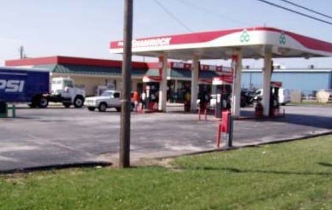
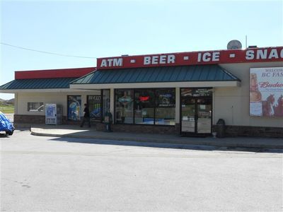
Property Record
1750 State Highway 14 E, Ozark, MO 65721

Property Detail
1750 State Highway 14 E
11-0.7-36-002-001-053.000
NWC NE NW E289 S301.5 W290 N301.5 TO POB EX E24
Agriculturalland
Christian
B and X Area of moderate flood hazard, usually the area between the limits of the 100-year and 500-year floods.
Missouri
2024
1.83 AC
2025
East Christian County
020303
Springfield
2,848 SF
Springfield, MO
NEARBY LISTINGS FOR SALE OR LEASE
DEMOGRAPHICS near 1750 State Highway 14 E
1 mile
3 mile
5 mile
2025 Total Population
4,479
16,798
32,548
2030 Population
4,744
17,791
34,464
Pop Growth 2025-2030
+ 5.92%
+ 5.91%
+ 5.89%
Average Age
38
39
39
2025 Total Households
1,629
6,134
11,931
HH Growth 2025-2030
+ 5.95%
+ 5.98%
+ 5.93%
Median Household Inc
$68,510
$74,428
$78,654
Avg Household Size
2.70
2.60
2.70
2025 Avg HH Vehicles
2.00
2.00
2.00
Median Home Value
$242,399
$270,634
$309,287
Median Year Built
1992
1995
1999
Nearby Places
Map Layers
Map Styles
 Street
 Aerial
Transit
 Traffic
 Biking
Places
Listings with unknown addresses are not visible on the map
- Restaurants
- Banks
- Shops
- Fitness
- Groceries
PUBLIC TRANSPORTATION
AIRPORT
Springfield-Branson Ntl
Drive
Walk
Distance
Springfield-Branson Ntl
46 min
32.4 mi
Nearby Properties
Address
Land Use
TOTAL SIZE
Lot Size
Zoning
Address
Land Use
TOTAL SIZE
Lot Size
Zoning
6,000 SF
50.60 AC
Address
Land Use
TOTAL SIZE
Lot Size
Zoning
2,942 SF
17.41 AC
Address
Land Use
TOTAL SIZE
Lot Size
Zoning
33,019 SF
6.24 AC
Address
Land Use
TOTAL SIZE
Lot Size
Zoning
131,905 SF
17.94 AC
Address
Land Use
TOTAL SIZE
Lot Size
Zoning
4,800 SF
10.57 AC
Address
Land Use
TOTAL SIZE
Lot Size
Zoning
2,100 SF
20 AC
Address
Land Use
TOTAL SIZE
Lot Size
Zoning
77,079 SF
28.40 AC
Address
Land Use
TOTAL SIZE
Lot Size
Zoning
48,227 SF
3.07 AC
Address
Land Use
TOTAL SIZE
Lot Size
Zoning
53,125 SF
8.01 AC
Address
Land Use
TOTAL SIZE
Lot Size
Zoning
41,000 SF
4.50 AC
Address
Land Use
TOTAL SIZE
Lot Size
Zoning
23,625 SF
7.98 AC
Address
Land Use
TOTAL SIZE
Lot Size
Zoning
Address
Land Use
TOTAL SIZE
Lot Size
Zoning
8,802 SF
5.26 AC
Address
Land Use
TOTAL SIZE
Lot Size
Zoning
5,760 SF
8.62 AC
Address
Land Use
TOTAL SIZE
Lot Size
Zoning
Address
Land Use
TOTAL SIZE
Lot Size
Zoning
23,112 SF
0.54 AC
Address
Land Use
TOTAL SIZE
Lot Size
Zoning
3,464 SF
13.34 AC
Address
Land Use
TOTAL SIZE
Lot Size
Zoning
28,000 SF
3.62 AC
Address
Land Use
TOTAL SIZE
Lot Size
Zoning
2,025 SF
4.89 AC
Address
Land Use
TOTAL SIZE
Lot Size
Zoning
1,476 SF
3.77 AC
Address
Land Use
TOTAL SIZE
Lot Size
Zoning
37,504 SF
6.12 AC
Address
Land Use
TOTAL SIZE
Lot Size
Zoning
32,000 SF
3.11 AC
Address
Land Use
TOTAL SIZE
Lot Size
Zoning
3,664 SF
2.81 AC
Address
Land Use
TOTAL SIZE
Lot Size
Zoning
3,654 SF
2.11 AC
Address
Land Use
TOTAL SIZE
Lot Size
Zoning
5,900 SF
1.53 AC
Address
Land Use
TOTAL SIZE
Lot Size
Zoning
6,310 SF
1.42 AC
Address
Land Use
TOTAL SIZE
Lot Size
Zoning
50,481 SF
4.20 AC
Address
Land Use
TOTAL SIZE
Lot Size
Zoning
47,954 SF
3.05 AC
Address
Land Use
TOTAL SIZE
Lot Size
Zoning
2,880 SF
1.46 AC
Address
Land Use
TOTAL SIZE
Lot Size
Zoning
3,050 SF
26.17 AC
The World's #1 Commercial Real Estate Marketplace
Connect with us
© 2026 CoStar Group
The information above has been obtained from sources believed reliable. While we do not doubt its accuracy we have not verified it and make no guarantee, warranty or representation about it. It is your responsibility to independently confirm its accuracy and completeness. Any projections, opinions, assumptions, or estimates used are for example only and do not represent the current or future performance of the property. The value of this transaction to you depends on tax and other factors which should be evaluated by your tax, financial, and legal advisors. You and your advisors should conduct a careful, independent investigation of the property to determine to your satisfaction the suitability of the property for your needs.