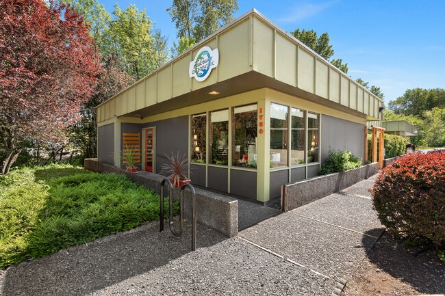
Property Record
1750 Sw 3Rd St, Corvallis, OR 97333


Save to a Folder
{{folder.Name}}
{{folder.ListingIds.length}} Properties
{{folder.ListingIds.length}} Property
Create a New Folder
Property Detail
1750 Sw 3Rd St
Industrialgeneral
Benton
MUE
Oregon
AE The base floodplain where base flood elevations are provided. AE Zones are now used on new format FIRMs instead of A1-A30 Zones.
2.95 AC
2025
Oregon West Area
2025
Other Market Areas
000101
Corvallis, OR
47,707 SF
158752
NEARBY LISTINGS FOR SALE OR LEASE
DEMOGRAPHICS near 1750 Sw 3Rd St
1 mile
3 mile
5 mile
2025 Total Population
13,402
54,094
75,232
2030 Population
14,263
56,693
78,159
Pop Growth 2025-2030
+ 6.42%
+ 4.80%
+ 3.89%
Average Age
31
35
37
2025 Total Households
5,130
21,325
30,173
HH Growth 2025-2030
+ 7.39%
+ 5.26%
+ 4.16%
Median Household Inc
$38,248
$57,255
$65,882
Avg Household Size
2.10
2.20
2.20
2025 Avg HH Vehicles
2.00
2.00
2.00
Median Home Value
$428,922
$498,032
$508,909
Median Year Built
1985
1981
1980
Nearby Places
Map Layers
Map Styles
 Street
 Aerial
Layers
 Traffic
 Biking
Places
Listings with unknown addresses are not visible on the map
- Restaurants
- Banks
- Shops
- Fitness
- Groceries
PUBLIC TRANSPORTATION
AIRPORT
Mahlon Sweet Field
Drive
Walk
Distance
Mahlon Sweet Field
54 min
34.6 mi
Freight Ports
Port of Portland
Drive
Walk
Distance
Port of Portland
111 min
87.3 mi
SALE & LEASE HISTORY
LISTING DATE
SALE/LEASE

Oct 01, 2020
For Lease
May 06, 2026
For Sale
Jan 10, 2024
For Lease
Nearby Properties
Address
Land Use
TOTAL SIZE
Lot Size
Zoning
Address
Land Use
TOTAL SIZE
Lot Size
Zoning
Address
Land Use
TOTAL SIZE
Lot Size
Zoning
Address
Land Use
TOTAL SIZE
Lot Size
Zoning
524,658 SF
25.99 AC
RS-12
Address
Land Use
TOTAL SIZE
Lot Size
Zoning
Address
Land Use
TOTAL SIZE
Lot Size
Zoning
169,502 SF
0.69 AC
RF
Address
Land Use
TOTAL SIZE
Lot Size
Zoning
330,690 SF
1.25 AC
MUE
Address
Land Use
TOTAL SIZE
Lot Size
Zoning
104,538 SF
4.38 AC
RS-12
Address
Land Use
TOTAL SIZE
Lot Size
Zoning
208,727 SF
16.20 AC
RS-20
Address
Land Use
TOTAL SIZE
Lot Size
Zoning
166,411 SF
3.04 AC
OSU
Address
Land Use
TOTAL SIZE
Lot Size
Zoning
81,112 SF
1.81 AC
PD(RS-20)
Address
Land Use
TOTAL SIZE
Lot Size
Zoning
Address
Land Use
TOTAL SIZE
Lot Size
Zoning
107,412 SF
9.16 AC
RTC
Address
Land Use
TOTAL SIZE
Lot Size
Zoning
146,932 SF
6.41 AC
MUCS
Address
Land Use
TOTAL SIZE
Lot Size
Zoning
235,104 SF
9.96 AC
PD(RS-20)
Address
Land Use
TOTAL SIZE
Lot Size
Zoning
159,910 SF
6.22 AC
RS-20
Address
Land Use
TOTAL SIZE
Lot Size
Zoning
67,923 SF
4.84 AC
RTC
Address
Land Use
TOTAL SIZE
Lot Size
Zoning
139,766 SF
6.41 AC
PD(RS-9)
Address
Land Use
TOTAL SIZE
Lot Size
Zoning
121,330 SF
10.62 AC
PD(RS-12)
Address
Land Use
TOTAL SIZE
Lot Size
Zoning
218,015 SF
11.69 AC
PD(RS-12)
Address
Land Use
TOTAL SIZE
Lot Size
Zoning
122,984 SF
2.56 AC
RS-20
Address
Land Use
TOTAL SIZE
Lot Size
Zoning
200,072 SF
11.08 AC
PD(GI)
Address
Land Use
TOTAL SIZE
Lot Size
Zoning
169.68 AC
PD(GI)
Address
Land Use
TOTAL SIZE
Lot Size
Zoning
159,058 SF
13.92 AC
RS-20
Address
Land Use
TOTAL SIZE
Lot Size
Zoning
94,542 SF
10.96 AC
PD(NC-MAJO
Address
Land Use
TOTAL SIZE
Lot Size
Zoning
117,960 SF
5.41 AC
RS-20
Address
Land Use
TOTAL SIZE
Lot Size
Zoning
224,384 SF
2.41 AC
MUCS
Address
Land Use
TOTAL SIZE
Lot Size
Zoning
136,117 SF
6.40 AC
PD(RS-9)
Address
Land Use
TOTAL SIZE
Lot Size
Zoning
63,978 SF
3.06 AC
PD(MUGC)
Address
Land Use
TOTAL SIZE
Lot Size
Zoning
123,198 SF
6.12 AC
PD(RS-20)
Address
Land Use
TOTAL SIZE
Lot Size
Zoning
109,984 SF
3.51 AC
RS-20
The World's #1 Commercial Real Estate Marketplace
Connect with us
© 2026 CoStar Group
The information above has been obtained from sources believed reliable. While we do not doubt its accuracy we have not verified it and make no guarantee, warranty or representation about it. It is your responsibility to independently confirm its accuracy and completeness. Any projections, opinions, assumptions, or estimates used are for example only and do not represent the current or future performance of the property. The value of this transaction to you depends on tax and other factors which should be evaluated by your tax, financial, and legal advisors. You and your advisors should conduct a careful, independent investigation of the property to determine to your satisfaction the suitability of the property for your needs.