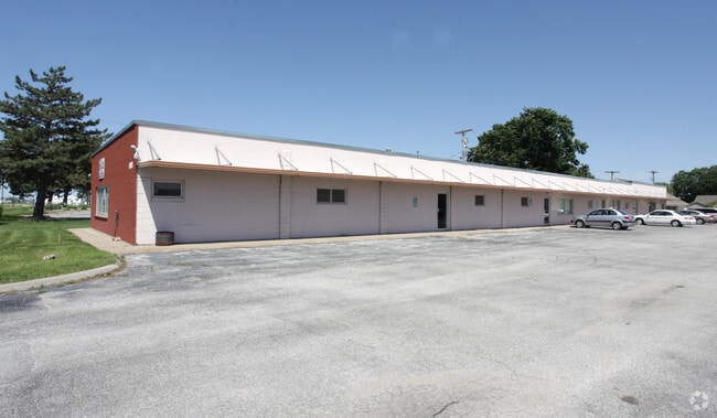
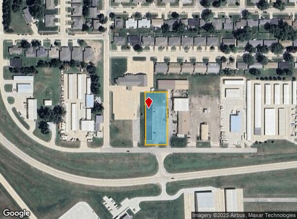
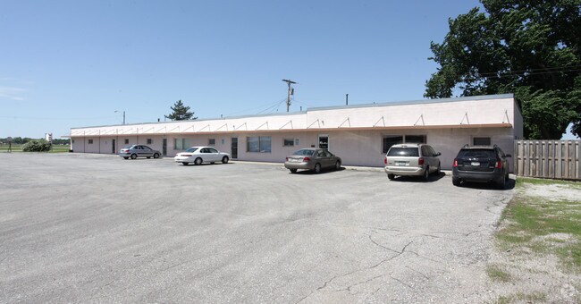
Property Record
1750 W 23Rd St, Fremont, NE 68025
NEARBY LISTINGS FOR SALE OR LEASE
Property Detail
1750 W 23Rd St
Fremont, NE
Seatons
270055398
SEATONS SUB W132' LOT 4; MAP NUMBER: 2391-10-3-91920-000-0000
Officebuilding
Dodge
AO
Nebraska
31155C0100D
4
2024
0.96 AC
2024
Nebraska Area
963800
Other Market Areas
8,120 SF
DEMOGRAPHICS near 1750 W 23Rd St
1 Mile
3 Mile
5 Mile
2024 Total Population
4,807
25,070
30,377
2029 Population
4,719
24,815
30,272
Pop Growth 2024-2029
(1.83%)
(1.02%)
(0.35%)
Average Age
40
39
40
2024 Total Households
1,990
10,006
12,080
HH Growth 2024-2029
(1.76%)
(0.98%)
(0.32%)
Median Household Inc
$57,719
$58,348
$61,710
Avg Household Size
2.30
2.40
2.40
2024 Avg HH Vehicles
2.00
2.00
2.00
Median Home Value
$175,141
$164,875
$173,230
Median Year Built
1973
1964
1968
Nearby Places
Map Layers
Map Styles
 Street
 Aerial
- Restaurants
- Banks
- Shops
- Fitness
- Groceries
Nearby Properties
Address
Land Use
TOTAL SIZE
Lot Size
Zoning
Address
Land Use
TOTAL SIZE
Lot Size
Zoning
7,385 SF
20.27 AC
INDUSTRIAL
Address
Land Use
TOTAL SIZE
Lot Size
Zoning
83,512 SF
94.84 AC
INDUSTRIAL
Address
Land Use
TOTAL SIZE
Lot Size
Zoning
7,504 SF
25.27 AC
INDUSTRIAL
Address
Land Use
TOTAL SIZE
Lot Size
Zoning
36,135 SF
8.89 AC
COMMERCIAL
Address
Land Use
TOTAL SIZE
Lot Size
Zoning
67,947 SF
10.67 AC
INDUSTRIAL
Address
Land Use
TOTAL SIZE
Lot Size
Zoning
33,392 SF
5.57 AC
SINGLE-FAM
Address
Land Use
TOTAL SIZE
Lot Size
Zoning
59,307 SF
1.99 AC
COMMERCIAL
Address
Land Use
TOTAL SIZE
Lot Size
Zoning
99,964 SF
7.47 AC
INDUSTRIAL
Address
Land Use
TOTAL SIZE
Lot Size
Zoning
3,000 SF
4.37 AC
INDUSTRIAL
Address
Land Use
TOTAL SIZE
Lot Size
Zoning
60,000 SF
11.02 AC
INDUSTRIAL
Address
Land Use
TOTAL SIZE
Lot Size
Zoning
65,589 SF
5.76 AC
COMMERCIAL
Address
Land Use
TOTAL SIZE
Lot Size
Zoning
21,384 SF
15 AC
INDUSTRIAL
Address
Land Use
TOTAL SIZE
Lot Size
Zoning
2,692 SF
19.27 AC
INDUSTRIAL
Address
Land Use
TOTAL SIZE
Lot Size
Zoning
4,952 SF
4.64 AC
MULTI-FAMI
Address
Land Use
TOTAL SIZE
Lot Size
Zoning
18,346 SF
2.94 AC
COMMERCIAL
Address
Land Use
TOTAL SIZE
Lot Size
Zoning
45,228 SF
2.01 AC
COMMERCIAL
Address
Land Use
TOTAL SIZE
Lot Size
Zoning
3,360 SF
4.99 AC
INDUSTRIAL
Address
Land Use
TOTAL SIZE
Lot Size
Zoning
43,560 SF
1.75 AC
COMMERCIAL
Address
Land Use
TOTAL SIZE
Lot Size
Zoning
59,225 SF
5.41 AC
COMMERCIAL
Address
Land Use
TOTAL SIZE
Lot Size
Zoning
9,870 SF
5.13 AC
COMMERCIAL
Address
Land Use
TOTAL SIZE
Lot Size
Zoning
22,928 SF
2.82 AC
INDUSTRIAL
Address
Land Use
TOTAL SIZE
Lot Size
Zoning
28,088 SF
10 AC
INDUSTRIAL
Address
Land Use
TOTAL SIZE
Lot Size
Zoning
16,360 SF
1.67 AC
COMMERCIAL
Address
Land Use
TOTAL SIZE
Lot Size
Zoning
11,810 SF
13.42 AC
COMMERCIAL
Address
Land Use
TOTAL SIZE
Lot Size
Zoning
49,481 SF
4.86 AC
COMMERCIAL
Address
Land Use
TOTAL SIZE
Lot Size
Zoning
3,510 SF
3.95 AC
INDUSTRIAL
Address
Land Use
TOTAL SIZE
Lot Size
Zoning
53,988 SF
5.07 AC
COMMERCIAL
Address
Land Use
TOTAL SIZE
Lot Size
Zoning
69,051 SF
9.60 AC
COMMERCIAL
Address
Land Use
TOTAL SIZE
Lot Size
Zoning
26,880 SF
5.11 AC
COMMERCIAL
The World's #1 Commercial Real Estate Marketplace
Connect with us
© 2026 CoStar Group
The information above has been obtained from sources believed reliable. While we do not doubt its accuracy we have not verified it and make no guarantee, warranty or representation about it. It is your responsibility to independently confirm its accuracy and completeness. Any projections, opinions, assumptions, or estimates used are for example only and do not represent the current or future performance of the property. The value of this transaction to you depends on tax and other factors which should be evaluated by your tax, financial, and legal advisors. You and your advisors should conduct a careful, independent investigation of the property to determine to your satisfaction the suitability of the property for your needs.