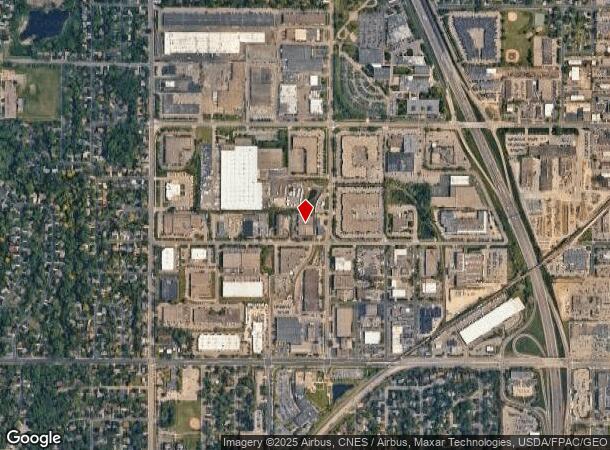
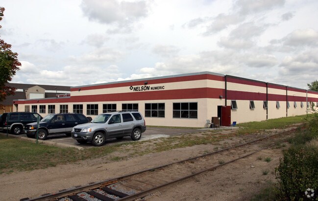
Property Record
1750 W 96Th St, Minneapolis, MN 55431


NEARBY LISTINGS FOR SALE OR LEASE
Property Detail
1750 W 96Th St
Minneapolis-St. Paul-Bloomington, MN-WI
Lee Stamping 1St Addn
16-027-24-21-0010
LOT 002 BLOCK 001 A LEE STAMPING 1ST ADDN 261.5 X 299.75
Industrialgeneral
Hennepin
X
Minnesota
27053C0458F
2
0
1.80 AC
2024
Southwest
025702
Minneapolis/St Paul
35,611 SF
DEMOGRAPHICS near 1750 W 96Th St
1 Mile
3 Mile
5 Mile
2024 Total Population
8,394
78,494
211,856
2029 Population
8,283
77,027
210,430
Pop Growth 2024-2029
(1.32%)
(1.87%)
(0.67%)
Average Age
43
42
42
2024 Total Households
3,698
33,849
89,900
HH Growth 2024-2029
(1.27%)
(1.99%)
(0.68%)
Median Household Inc
$70,229
$76,378
$82,428
Avg Household Size
2.20
2.20
2.30
2024 Avg HH Vehicles
2.00
2.00
2.00
Median Home Value
$298,836
$295,054
$316,578
Median Year Built
1967
1966
1971
Nearby Places
Map Layers
Map Styles
 Street
 Aerial
- Restaurants
- Banks
- Shops
- Fitness
- Groceries
PUBLIC TRANSPORTATION
AIRPORT
Minneapolis-St Paul International/Wold-Chamberlain
DRIVE
WALK
Distance
Minneapolis-St Paul International/Wold-Chamberlain
14 min
7.8 mi
SALE & LEASE HISTORY
LISTING DATE
SALE/LEASE

Dec 10, 2020
For Lease
Dec 07, 2020
For Sale
Nearby Properties
Address
Land Use
TOTAL SIZE
Lot Size
Zoning
Address
Land Use
TOTAL SIZE
Lot Size
Zoning
1,341.19 AC
Address
Land Use
TOTAL SIZE
Lot Size
Zoning
21.50 AC
Address
Land Use
TOTAL SIZE
Lot Size
Zoning
35.28 AC
Address
Land Use
TOTAL SIZE
Lot Size
Zoning
8.55 AC
Address
Land Use
TOTAL SIZE
Lot Size
Zoning
25,780 SF
5.24 AC
Address
Land Use
TOTAL SIZE
Lot Size
Zoning
435,796 SF
36.44 AC
Address
Land Use
TOTAL SIZE
Lot Size
Zoning
129,658 SF
13.52 AC
Address
Land Use
TOTAL SIZE
Lot Size
Zoning
105,658 SF
18.80 AC
Address
Land Use
TOTAL SIZE
Lot Size
Zoning
22,119 SF
4.02 AC
Address
Land Use
TOTAL SIZE
Lot Size
Zoning
Address
Land Use
TOTAL SIZE
Lot Size
Zoning
122,021 SF
21.74 AC
Address
Land Use
TOTAL SIZE
Lot Size
Zoning
60,320 SF
11.50 AC
Address
Land Use
TOTAL SIZE
Lot Size
Zoning
22,393 SF
4.12 AC
Address
Land Use
TOTAL SIZE
Lot Size
Zoning
137,728 SF
11.31 AC
Address
Land Use
TOTAL SIZE
Lot Size
Zoning
Address
Land Use
TOTAL SIZE
Lot Size
Zoning
6.87 AC
Address
Land Use
TOTAL SIZE
Lot Size
Zoning
142,229 SF
26.61 AC
Address
Land Use
TOTAL SIZE
Lot Size
Zoning
12.88 AC
Address
Land Use
TOTAL SIZE
Lot Size
Zoning
32,748 SF
2.24 AC
Address
Land Use
TOTAL SIZE
Lot Size
Zoning
332,938 SF
15.61 AC
Address
Land Use
TOTAL SIZE
Lot Size
Zoning
19,441 SF
1.37 AC
Address
Land Use
TOTAL SIZE
Lot Size
Zoning
42,338 SF
5.15 AC
Address
Land Use
TOTAL SIZE
Lot Size
Zoning
66,845 SF
6.44 AC
MDD6
Address
Land Use
TOTAL SIZE
Lot Size
Zoning
5.83 AC
Address
Land Use
TOTAL SIZE
Lot Size
Zoning
52,316 SF
3.56 AC
MDD6
Address
Land Use
TOTAL SIZE
Lot Size
Zoning
69,556 SF
6.50 AC
MDD6
Address
Land Use
TOTAL SIZE
Lot Size
Zoning
52,316 SF
4.81 AC
MDD6
Address
Land Use
TOTAL SIZE
Lot Size
Zoning
24,209 SF
5.90 AC
Address
Land Use
TOTAL SIZE
Lot Size
Zoning
17,667 SF
3.45 AC
MDD6
Address
Land Use
TOTAL SIZE
Lot Size
Zoning
102,132 SF
15.02 AC
The World's #1 Commercial Real Estate Marketplace
Connect with us
© 2025 CoStar Group
The information above has been obtained from sources believed reliable. While we do not doubt its accuracy we have not verified it and make no guarantee, warranty or representation about it. It is your responsibility to independently confirm its accuracy and completeness. Any projections, opinions, assumptions, or estimates used are for example only and do not represent the current or future performance of the property. The value of this transaction to you depends on tax and other factors which should be evaluated by your tax, financial, and legal advisors. You and your advisors should conduct a careful, independent investigation of the property to determine to your satisfaction the suitability of the property for your needs.