Property Record
17500 Interstate 35 N, Schertz, TX 78154
NEARBY LISTINGS FOR SALE OR LEASE
-
-
View all Schertz listings for sale on LoopNet.com
Property Detail
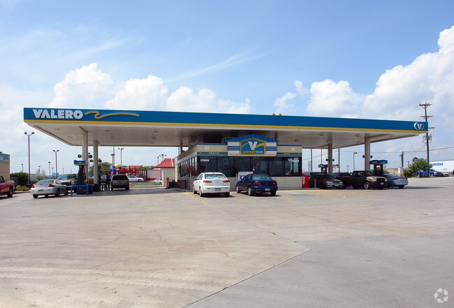
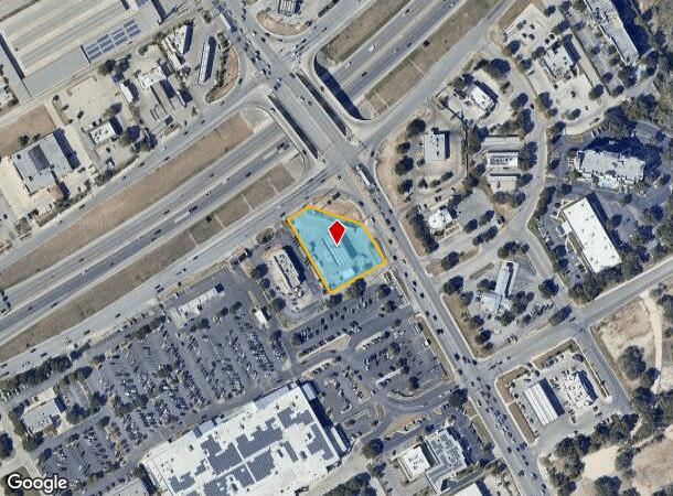
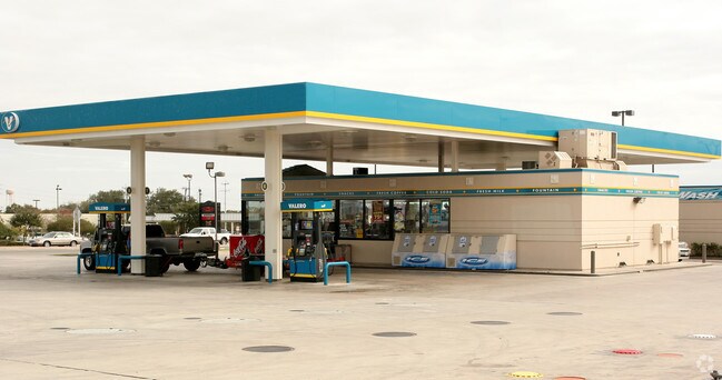
17500 Interstate 35 N
San Antonio-New Braunfels, TX
Diamond Shamrock
1G0777-0001-00100-0-00
LOT: 1 BLK: 1 ADDN: DIAMOND SHAMROCK-35 0.9910 AC.
Commercialnec
Guadalupe
X
Texas
48029C0285F
1
2024
0.99 AC
2025
Guadalupe County
210709
San Antonio
2,304 SF
DEMOGRAPHICS near 17500 Interstate 35 N
1 Mile
3 Mile
5 Mile
2024 Total Population
4,860
55,267
120,928
2029 Population
5,509
63,166
136,334
Pop Growth 2024-2029
+ 13.35%
+ 14.29%
+ 12.74%
Average Age
40
39
38
2024 Total Households
1,727
19,269
43,331
HH Growth 2024-2029
+ 13.49%
+ 14.51%
+ 12.66%
Median Household Inc
$113,104
$102,579
$89,896
Avg Household Size
2.80
2.80
2.80
2024 Avg HH Vehicles
2.00
2.00
2.00
Median Home Value
$263,984
$264,104
$256,327
Median Year Built
2000
2003
2002
Nearby Places
Map Layers
Map Styles
 Street
 Aerial
- Restaurants
- Banks
- Shops
- Fitness
- Groceries
PUBLIC TRANSPORTATION
AIRPORT
San Antonio International
DRIVE
WALK
Distance
San Antonio International
20 min
14.7 mi
Freight Ports
Calhoun Port
DRIVE
WALK
Distance
Calhoun Port
182 min
149.4 mi
Nearby Properties
Address
Land Use
TOTAL SIZE
Lot Size
Zoning
Address
Land Use
TOTAL SIZE
Lot Size
Zoning
538,168 SF
176.13 AC
Address
Land Use
TOTAL SIZE
Lot Size
Zoning
566,929 SF
89.66 AC
Address
Land Use
TOTAL SIZE
Lot Size
Zoning
116.47 AC
Address
Land Use
TOTAL SIZE
Lot Size
Zoning
95,470 SF
35.26 AC
Address
Land Use
TOTAL SIZE
Lot Size
Zoning
Address
Land Use
TOTAL SIZE
Lot Size
Zoning
214,405 SF
11.85 AC
Address
Land Use
TOTAL SIZE
Lot Size
Zoning
412,136 SF
49 AC
Address
Land Use
TOTAL SIZE
Lot Size
Zoning
151,529 SF
18.40 AC
Address
Land Use
TOTAL SIZE
Lot Size
Zoning
55,640 SF
24.17 AC
Address
Land Use
TOTAL SIZE
Lot Size
Zoning
511,000 SF
32.40 AC
Address
Land Use
TOTAL SIZE
Lot Size
Zoning
430,320 SF
25.03 AC
Address
Land Use
TOTAL SIZE
Lot Size
Zoning
111,269 SF
73.47 AC
Address
Land Use
TOTAL SIZE
Lot Size
Zoning
7,176 SF
24.22 AC
Address
Land Use
TOTAL SIZE
Lot Size
Zoning
358,036 SF
20.77 AC
Address
Land Use
TOTAL SIZE
Lot Size
Zoning
223,965 SF
14.45 AC
Address
Land Use
TOTAL SIZE
Lot Size
Zoning
86,124 SF
9.37 AC
Address
Land Use
TOTAL SIZE
Lot Size
Zoning
147,780 SF
15 AC
Address
Land Use
TOTAL SIZE
Lot Size
Zoning
73,813 SF
17.33 AC
Address
Land Use
TOTAL SIZE
Lot Size
Zoning
312,696 SF
18.01 AC
Address
Land Use
TOTAL SIZE
Lot Size
Zoning
308,264 SF
26.51 AC
Address
Land Use
TOTAL SIZE
Lot Size
Zoning
307,240 SF
20.16 AC
Address
Land Use
TOTAL SIZE
Lot Size
Zoning
112,870 SF
13.32 AC
Address
Land Use
TOTAL SIZE
Lot Size
Zoning
576 SF
41.86 AC
Address
Land Use
TOTAL SIZE
Lot Size
Zoning
113,091 SF
12.60 AC
Address
Land Use
TOTAL SIZE
Lot Size
Zoning
321,016 SF
18.67 AC
Address
Land Use
TOTAL SIZE
Lot Size
Zoning
103,044 SF
13.50 AC
Address
Land Use
TOTAL SIZE
Lot Size
Zoning
30,994 SF
29.09 AC
Address
Land Use
TOTAL SIZE
Lot Size
Zoning
267,716 SF
21.11 AC
Address
Land Use
TOTAL SIZE
Lot Size
Zoning
109,469 SF
5.88 AC
Address
Land Use
TOTAL SIZE
Lot Size
Zoning
187,650 SF
42.50 AC
The World's #1 Commercial Real Estate Marketplace
Connect with us
© 2025 CoStar Group
The information above has been obtained from sources believed reliable. While we do not doubt its accuracy we have not verified it and make no guarantee, warranty or representation about it. It is your responsibility to independently confirm its accuracy and completeness. Any projections, opinions, assumptions, or estimates used are for example only and do not represent the current or future performance of the property. The value of this transaction to you depends on tax and other factors which should be evaluated by your tax, financial, and legal advisors. You and your advisors should conduct a careful, independent investigation of the property to determine to your satisfaction the suitability of the property for your needs.