Property Record
17440 Ne Us Highway 301, Waldo, FL 32694
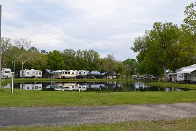
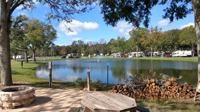
This Property Is For Sale
NEARBY LISTINGS FOR SALE OR LEASE
Property Detail
17440 Ne Us Highway 301
16972-056-000
COM SE COR OF SW1/4 OF NE1/4 S 88 DEG 31 MIN 29 SEC W 1035.92 FT POB S 88 DEG 31 MIN 29 SEC W 286.35 FT N 01 DEG 13 MIN 43 SEC W 1322.49 FT N 01 DEG 13 MIN 43 SEC W 29.55 FT N 88 DEG 26 MIN 02 SEC E 722.37 FT S 01 DEG 09 MIN 59 SEC E 208.71 FT N 88 D
Recreationalentertainmentgeneral
Alachua
A
Florida
12007C0260E
18.43 AC
2025
Gainesville
2025
Other Market Areas
001907
Gainesville, FL
1,288 SF
DEMOGRAPHICS near 17440 Ne Us Highway 301
1 Mile
3 Mile
5 Mile
2024 Total Population
101
1,511
3,738
2029 Population
104
1,579
3,903
Pop Growth 2024-2029
+ 2.97%
+ 4.50%
+ 4.41%
Average Age
41
43
43
2024 Total Households
45
627
1,526
HH Growth 2024-2029
+ 4.44%
+ 4.15%
+ 3.80%
Median Household Inc
$23,586
$36,111
$44,057
Avg Household Size
2.10
2.40
2.40
2024 Avg HH Vehicles
2.00
2.00
2.00
Median Home Value
$145,454
$146,195
$142,266
Median Year Built
1949
1980
1983
Nearby Places
Map Layers
Map Styles
 Street
 Aerial
- Restaurants
- Banks
- Shops
- Fitness
- Groceries
PUBLIC TRANSPORTATION
AIRPORT
Gainesville Regional
DRIVE
WALK
Distance
Gainesville Regional
23 min
13.8 mi
Freight Ports
Jacksonville Port
DRIVE
WALK
Distance
Jacksonville Port
75 min
59.3 mi
Nearby Properties
Address
Land Use
TOTAL SIZE
Lot Size
Zoning
Address
Land Use
TOTAL SIZE
Lot Size
Zoning
24,076 SF
2 AC
W301
Address
Land Use
TOTAL SIZE
Lot Size
Zoning
38,426 SF
7.16 AC
CC
Address
Land Use
TOTAL SIZE
Lot Size
Zoning
30,134 SF
3.41 AC
RESMED
Address
Land Use
TOTAL SIZE
Lot Size
Zoning
19,220 SF
2.84 AC
RESMED
Address
Land Use
TOTAL SIZE
Lot Size
Zoning
9,645 SF
4 AC
W301
Address
Land Use
TOTAL SIZE
Lot Size
Zoning
24,000 SF
4.70 AC
COMM
Address
Land Use
TOTAL SIZE
Lot Size
Zoning
21,792 SF
39.70 AC
W301
Address
Land Use
TOTAL SIZE
Lot Size
Zoning
13,640 SF
1.84 AC
W301
Address
Land Use
TOTAL SIZE
Lot Size
Zoning
882 SF
79.56 AC
W301
Address
Land Use
TOTAL SIZE
Lot Size
Zoning
191 SF
7 AC
W301
Address
Land Use
TOTAL SIZE
Lot Size
Zoning
3,247 SF
2.01 AC
LIND
Address
Land Use
TOTAL SIZE
Lot Size
Zoning
3,339 SF
2.71 AC
COMM
Address
Land Use
TOTAL SIZE
Lot Size
Zoning
8,500 SF
1.94 AC
CC
Address
Land Use
TOTAL SIZE
Lot Size
Zoning
7,865 SF
0.80 AC
COMM
Address
Land Use
TOTAL SIZE
Lot Size
Zoning
9,012 SF
1.09 AC
C0MM
Address
Land Use
TOTAL SIZE
Lot Size
Zoning
5,584 SF
1.05 AC
BH
Address
Land Use
TOTAL SIZE
Lot Size
Zoning
1,699 SF
1.28 AC
W301
Address
Land Use
TOTAL SIZE
Lot Size
Zoning
3,598 SF
1.80 AC
COMM
Address
Land Use
TOTAL SIZE
Lot Size
Zoning
8,072 SF
1.09 AC
RESMED
Address
Land Use
TOTAL SIZE
Lot Size
Zoning
3,908 SF
10.25 AC
Address
Land Use
TOTAL SIZE
Lot Size
Zoning
1,923 SF
4.04 AC
REC
Address
Land Use
TOTAL SIZE
Lot Size
Zoning
1,827 SF
110.26 AC
A
Address
Land Use
TOTAL SIZE
Lot Size
Zoning
5,718 SF
10.79 AC
Address
Land Use
TOTAL SIZE
Lot Size
Zoning
1,440 SF
0.92 AC
C0MM
Address
Land Use
TOTAL SIZE
Lot Size
Zoning
2,712 SF
0.23 AC
CC
Address
Land Use
TOTAL SIZE
Lot Size
Zoning
2,152 SF
12.94 AC
Address
Land Use
TOTAL SIZE
Lot Size
Zoning
2,224 SF
0.26 AC
CC
Address
Land Use
TOTAL SIZE
Lot Size
Zoning
0.55 AC
CC
The World's #1 Commercial Real Estate Marketplace
Connect with us
© 2026 CoStar Group
The information above has been obtained from sources believed reliable. While we do not doubt its accuracy we have not verified it and make no guarantee, warranty or representation about it. It is your responsibility to independently confirm its accuracy and completeness. Any projections, opinions, assumptions, or estimates used are for example only and do not represent the current or future performance of the property. The value of this transaction to you depends on tax and other factors which should be evaluated by your tax, financial, and legal advisors. You and your advisors should conduct a careful, independent investigation of the property to determine to your satisfaction the suitability of the property for your needs.